

North/south split in January stats
Author: Press Office
12:17 (UTC) on Thu 1 Feb 2018
Provisional statistics for January 2018 show it was slightly sunnier and colder than average in the north, but a somewhat different story for the south.
The month got off to a wet and windy start when Storm Eleanor moved across the UK on 2 and 3 January, and this also brought mild conditions to the south. Then after a spell of quieter weather due to the influence of a nearby high pressure things turned more unsettled from the middle of the month.
Successive frontal systems drove across the UK bringing strong winds, heavy rain and significant snowfall, especially in upland areas of the north and west; Eskdalemuir had a snow depth of 38 cm on 17 January.
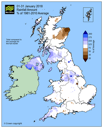
Some parts of Scotland have had a significantly drier than average month, with Aberdeenshire having less than half the 1981-2010 January average with just 45.2 mm. However further south it’s been a wetter month; England and Wales were both around average whilst Northern Ireland had almost 50% more than average with 171.1 mm.
|
1-31 Jan 2018 |
Precipitation |
Sunshine |
||
|
Actual |
% of avg |
Actual hrs |
% of avg |
|
|
UK |
130.5 |
107 |
49.7 |
105 |
|
England |
88.6 |
107 |
55.4 |
102 |
|
Wales |
164 |
104 |
43.4 |
89 |
|
Scotland |
183.5 |
103 |
42 |
117 |
|
N Ireland |
171.1 |
147 |
47.9 |
108 |
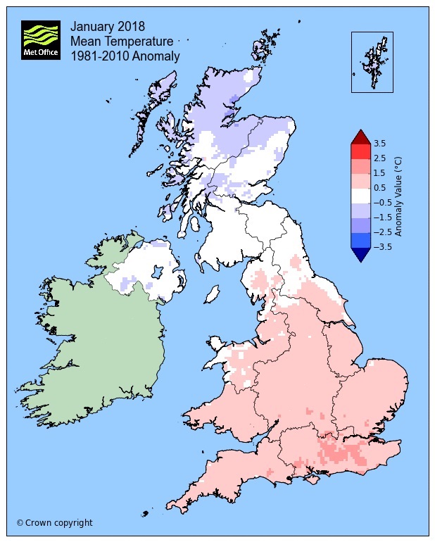
The UK as a whole had an average mean temperature of 4.1 °C, which is 0.4 °C above the 1981-2010 average. Scotland and Northern Ireland were both a little below average whilst England and Wales were both above by 1.0 and 0.7 °C respectively.
|
1-31 Jan 2018 Provisional figures |
Max temp |
Min temp |
Mean temp |
|||
|
Actual (°C) |
Diff from avg (°C) |
Actual (°C) |
Diff from avg (°C) |
Actual (°C) |
Diff from avg (°C) |
|
|
UK |
6.7 |
0.3 |
1.4 |
0.5 |
4.1 |
0.4 |
|
England |
7.9 |
1 |
2.3 |
1 |
5.1 |
1 |
|
Wales |
7.5 |
0.7 |
2.1 |
0.6 |
4.8 |
0.7 |
|
Scotland |
4.6 |
-0.7 |
-0.3 |
-0.3 |
2.1 |
-0.5 |
|
N Ireland |
6.6 |
-0.5 |
1.3 |
-0.1 |
3.9 |
-0.3 |
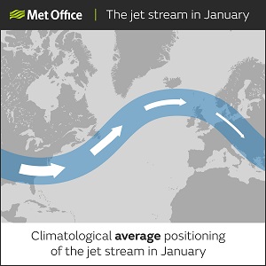
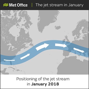
The north/south contrast is partly down to the positioning of the jet stream. In January 2018 the jet was running further south across the UK than is climatologically average, and it was also stronger than average across western Europe.
The positioning and intensity of the jet stream not only led to the contrast in weather across the UK, but also the severe weather seen in France. Heavy rain in Paris has led to flood levels in the capital city rising to almost 6 metres, around 4 metres higher than average, with the River Seine bursting its banks.
Looking ahead through February and the month is getting off to a cold start. Temperatures will be below average to end the working week with some showers too. Then after a slightly milder but also wet Saturday temperatures will drop again into the new working week. This means we can expect below average temperatures, harsh overnight frosts and also some snow. Confidence in where and when we will see any snow will increase nearer the time.
You can find out the current forecast in your area using our forecast pages and by following us on Twitter and Facebook, as well as using our mobile app which is available for iPhone from the App store and for Android from the Google Play store.
The monthly statistics for January 2018 remain provisional.