Altostratus clouds
Altostratus evolves as a thin layer from a gradually thickening veil of cirrostratus and is usually grey or blue, with very few features.
- Height of base: 6,500 - 20,000 ft
- Shape: Layered and featureless
- Latin: altum - height; stratus - flattened or spread out
- Precipitation: None
What are altostratus clouds?
Altostratus are large mid-level sheets of thin cloud. Usually composed of a mixture of water droplets and ice crystals, they are thin enough in parts to allow you to see the Sun weakly through the cloud. They are often spread over a very large area and are typically featureless.
How do altostratus clouds form?
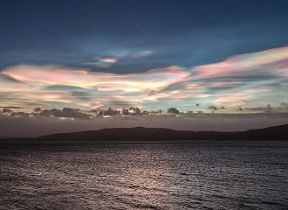
Altostratus layers are often composed of both water and ice and usually form when a layer of cirrostratus descends from a higher level. The Sun often cannot cast shadows when shining through altostratus clouds. These layers can sometimes contribute to the formation of optical effects such as coronas and iridescence.
What weather is associated with altostratus clouds?
Altostratus clouds often form ahead of a warm or occluded front. As the front passes, the altostratus layer deepens and bulks out to become nimbostratus, which produces rain or snow. As a result, sighting it can usually indicate a change in the weather is on the way.
How do we categorise altostratus clouds?
Altostratus clouds are featureless with little character, so are not classified into 'species' like other cloud types. They are similar to nimbostratus in this way. They do have many pattern-based varieties though, such as undulatus, radiatus and duplicatus, and thickness based varieties; translucidus and opacus.


