
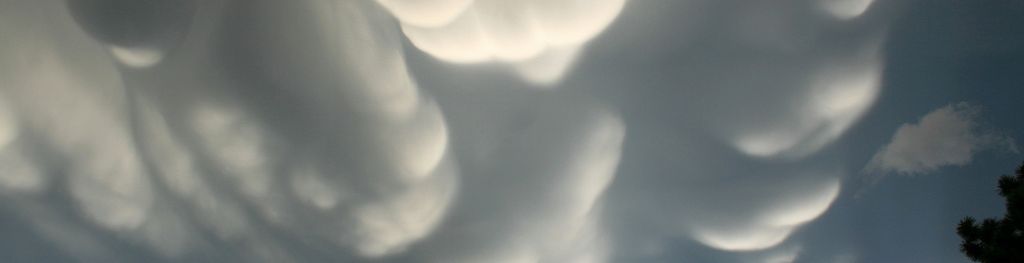
Mammatus clouds
Mammatus clouds are some of the most unusual and distinctive clouds formations with a series of bulges or pouches emerging from the base of a cloud.
What are mammatus clouds?
Mammatus clouds are some of the most unusual and distinctive clouds formations with a series of bulges or pouches emerging from the base of a cloud. The shape of mammatus formations can vary widely; from the classic protruding shape, to a more elongated tube hanging from the cloud above.
How do mammatus clouds form?
Mammatus clouds are usually formed in association with large cumulonimbus clouds. Typically, turbulence within the cumulonimbus cloud will cause mammatus to form, especially on the underside of the projecting anvil as it rapidly descends to lower levels. This reverses the usual cloud-forming process of upward growth, making for an uneven cloud base.
What weather is associated with mammatus clouds?
Mammatus often forms in association with Cumulonimbus clouds, which in turn bring thunderstorms due to their huge mass of unstable air. Mammatus cloud generally form in the most unstable cumulonimbus, meaning that there is also a chance of hail, heavy rain and lightning in the vicinity, and if the air is cold enough during winter they can produce snow. Sometimes mammatus may form on other cloud types which produce no rain, though this is far less common.
Mammatus comes from the Latin mamma which translates to "udder" or "breast". Their striking appearance is most visible when the sun is low in the sky and their pouches are framed by the sunlight. This supplementary feature is a firm favourite with many meteorologists as well as cloud and photography enthusiasts.
What clouds are associated with mammatus?
Mammatus usually form on the base of a cumulonimbus anvil, but they have also been sighted to form on other cloud types, such as stratocumulus, altostratus and altocumulus. Mammatus have also been observed to form on the underside of volcanic ash clouds.