CRUTEM4 dataset
Data set deprecation: CRUTEM4 has been superseded by CRUTEM5.
Further use of CRUTEM4 is not recommended for purposes other than comparison with newer data sets.
CRUTEM4 is a gridded dataset of global historical near-surface air temperature anomalies over land. Data are available for each month from January 1850 to present, on a 5 degree grid. The dataset is a collaborative product of the Met Office Hadley Centre and the Climatic Research Unit at the University of East Anglia. Release notes for this version (CRUTEM.4.6.0.0) are available here. Previous versions of the CRUTEM4 dataset are available here.
Brief description of the data
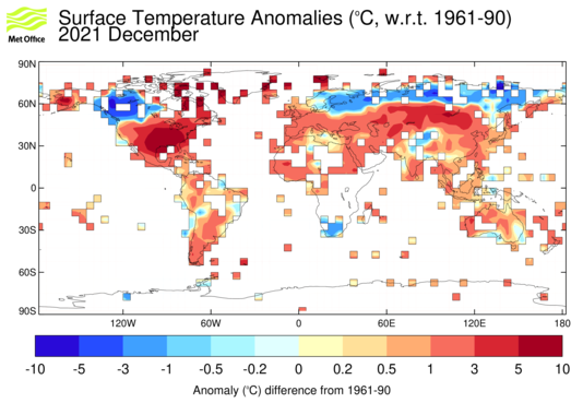
The gridded data are based on an archive of monthly mean temperatures provided by more than 5500 weather stations distributed around the world. Each station temperature is converted to an anomaly from the 1961-90 average temperature for that station, and each grid-box value is the mean of all the station anomalies within that grid box. As well as the mean anomaly, estimates are made of the uncertainties arising from thermometer accuracy, homogenisation, sampling grid boxes with a finite number of measurements available, large-scale biases such as urbanisation and estimation of regional averages with non-complete global measurement coverage.
|
|
Commercial and media enquiries
You can access the Met Office Customer Centre, any time of the day or night by phone, fax or e-mail. Trained staff will help you find the information or products that are right for you.
Contact the Met Office Customer Centre
|
References
When using the data set in a paper, the following is the correct citation to use:
Jones, P. D., D. H. Lister, T. J. Osborn, C. Harpham, M. Salmon, and C. P. Morice (2012), Hemispheric and large-scale land surface air temperature variations: An extensive revision and an update to 2010, J. Geophys. Res., 117, D05127, doi:10.1029/2011JD017139
If you use the information provided by the Google Earth interface, then please also acknowledge this by citing:
Osborn T.J. and Jones P.D., 2014: The CRUTEM4 land-surface air temperature dataset: construction, previous versions and dissemination via Google Earth. Earth System Science Data 6, 61-68. doi: 10.5194/essd-6-61-2014
|
|
Other information
Various diagnostics are produced from the monthly gridded fields. These include global and regional time-series.
Dataset version information and previous versions.
Summaries of CLIMAT message data used in monthly updates.
Google Earth interface for CRUTEM4 land temperature data.
Dataset produced in collaboration with: