D-Day - the most important weather forecast in history
The Met Office played a crucial role in the timing of D-Day that became known as the largest amphibious invasion in military history.
Weather forecasting in 1944
In 1944 critical military decisions were made based on weather forecasts. These were compiled using data gathered from air reconnaissance, ship observations (often sent ashore using pigeons), UK observation sites, and from the Germans - once the allies broke the Enigma code. All observation sites were manned, as opposed to automated as they later became, and charts were hand-drawn every few hours. The German weather charts were drawn using much fewer observations than Allied charts.
National Meteorological Archivist Catherine Ross said: "The Allied charts contain a wealth of observations from across the UK and Europe. By contrast, the German charts reveal that they had been unable to crack the Allied codes. As a result there are virtually no observations for the UK and surrounding waters. The difference in the information available to both sides gave the allies a crucial advantage on D-Day."
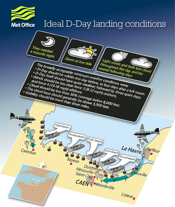
Group Captain James Stagg, RAF and Chief Meteorological Officer at Supreme Headquarters Allied Expeditionary Force, led a team of meteorologists charged with providing forecasts to the Allied Commanders deciding when to launch the D-Day offensives. They considered all the elements that would impact operations and drew up a wish list of ideal conditions for the D-Day landings.
When the weather conditions were suitable, more than 5,000 ships and 13,000 aircraft supported the D-Day invasion on 6 June 1944. 160,000 Allied troops landed along a 50-mile stretch of heavily-fortified French coastline to fight Nazi Germany on the beaches of Normandy, France.
Afterwards, Stagg wrote on the bottom of an official report to General Eisenhower that, if the invasion had been delayed until the next suitable tides, the troops would have met the worst Channel weather for 20 years. Eisenhower wrote on the letter: "Thanks, and thank the Gods of war we went when we did."
In the videos below, Deputy Chief Meteorologist Chris Tubbs interprets the original, hand-drawn charts that the Met Office compiled for the D-Day landings.
Using weather charts to gain military advantage
The weather was considered a matter of national security. For this reason, neither side issued public weather forecasts for the duration of the war. However, because the Allies had cracked the German Enigma code, the D-Day forecasters had access to German meteorological observations as well as observations from Allied observers and reconnaissance flights. This is shown on weather charts held in the Met Office National Meteorological Archive in Exeter.
The German weather charts, rediscovered in recent years by the German Weather Service (DWD), have shown the Allied forecasters were at a significant advantage over the German forecasters in terms of being able to spot a suitable weather window for an invasion.
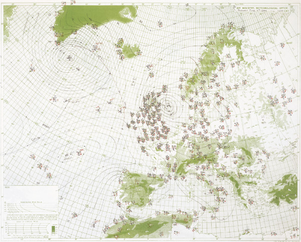
Image (above) of a weather map for the Allies
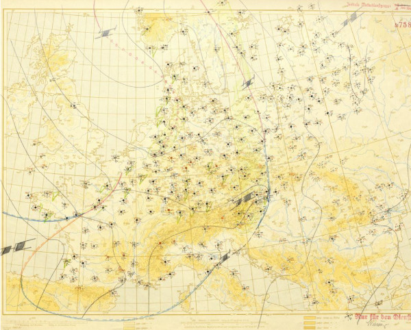
Image (above) of weather map for the Germans
DWD Library Director Dr. Jörg Rapp said: "When comparing the work cards of the Allies it is immediately noticeable that the German side had plenty of weather reports, largely from parts of the European continent and areas under the influence of the then German Empire. This included information from weather reconnaissance flights and submarines as well as Russian decrypted data. However, better meteorological data can be seen, in retrospect, to have given the Allies a decisive advantage."
German forces continued to forecast that the weather conditions would remain unsuitable for an Allied assault. However, with access to the additional observation data, the allied forecasters had sufficient information to be able to plot the location and movement of a ridge of high pressure over the Atlantic. So, Group Captain James Stagg was able to advise that conditions on 6 June would be marginal, but sufficient, to launch the invasion. In so doing, the D-Day forecasters made perhaps the most important forecast in Met Office history.
Supporting modern-day military operations
Today, the UK armed forces are still dependent on weather forecasts when planning manoeuvres and operations. The Met Office Mobile Met Unit, an RAF Sponsored Reserves Unit, supports military operations and exercises in the UK and around the world. It consists of weather forecasters and engineers who undergo military as well as meteorological training. They travel with Armed Forces personnel, and give them advice about the potential impact of weather on armed operations.
In the video below, a former Met Office meteorologist and officer in the Royal Air Force Reserve, describes his daily life on a military base in Afghanistan. He explains how he complied forecasts and briefed military personnel prior to operations, just as the Met Office staff did during D-Day operations and throughout World War II.