
About our forecasts
We provide forecasts from a few hours ahead to projections more than a century into the future.
The timescale of each forecast greatly determines the level of detail we can give. Here's a guide to each type of forecast and what you can expect from it.
One- to two-day forecast
A detailed forecast of what's to come today and tomorrow, for regions, towns and cities describing the expected weather, temperatures and wind speeds along with detailed and timely warnings of severe weather. It is not yet possible to pinpoint exactly where and when localised weather, such as showers or fog patches, will happen, though we are able to identify the likelihood of this type of weather occurring.
Three- to five-day forecast
A general picture of the weather on a day-by-day basis, with the main regional variations identified. We have a good track record in advising on any significant risk of severe weather in this period.
Six- to fifteen-day forecast
A broad description of the weather likely to be affecting the UK, including significant changes in the type of weather. We'll also give a risk assessment of severe weather, such as heavy rainfall, severe gales or an extended period of high or low temperatures.
16-30 day outlook
An indication of how the weather might change, or be different from normal, (i.e. warmer, colder, wetter, drier) across the whole UK.
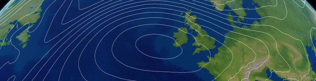
When looking at forecasts beyond five days into the future the chaotic nature of the atmosphere begins to play a larger part - small events currently over the Atlantic can have potentially significant impacts on our weather in the UK in several days time. Therefore whilst we can still forecast the general feel of the weather to a relatively high level of accuracy using our Ensemble Forecasting, it becomes harder to offer local detail to as high a level of accuracy as our shorter range forecasts. For this reason our forecasts for 5 days and beyond are written on the scale of the UK as a whole.
Location specific forecasts
Our location specific forecasts are provided in hourly time steps for the first two days and then in three hourly time steps for days three to seven. These give an indication of the most likely predominant weather conditions for that location for the time specified. For example, if our forecasts models predict sunny intervals with just a small chance of a short light shower, then the symbol which is displayed is likely to be the sunny interval symbol. This is because the predominant weather type during the period is sunny intervals.
These forecasts take into account the weather in preceding and following hour to allow for small variations in timing, for example the 1500 forecast also takes into account our predications for 1400 and 1600.
Chance of rain/snow (Probability of Precipitation)
The site specific weather symbol forecasts should be used alongside the chance of rain/snow (probability of precipitation) forecast to give a more detailed view of the likely weather. The example below shows an example where the weather is expected to be cloudy. However the 20% value in the chance of rain/snow column shows that although predominately we expect the weather to be dry, there is still a small chance that rain may occur.
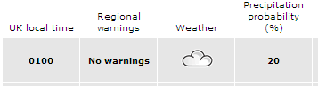
This indicates the importance of considering both the weather symbol and chance of rain/snow together to give a complete picture of the expected weather conditions.
Interpreting forecasts
When viewing forecasts and observations it is important to remember that this is subjective and we each view actual and forecast weather in different ways. For example, what one person considers cloudy another may consider sunny intervals. It is also sometimes possible to look in one direction and it to be cloudy with a shower approaching, but to look in the opposite direction and see blue skies.
Forecast accuracy product
The forecast accuracy product provides a comparison between the weather we forecast and the actual weather for the current day for a number of locations across the country. You can compare the forecast we made at 6pm yesterday to the actual temperature and weather through the day. This comparison is a simple visual guide to the accuracy of our forecasts, not a robust scientific verification.
The forecasts displayed use our location specific forecasts including temperature, weather and chance of rain/snow (probability of precipitation). See our advice on interpreting our forecasts.
The observations displayed are for the same location as the forecast and cover temperature and weather type. These are available every hour and are spot observations for the time displayed which doesn't take into account the weather observed at either side of that time. It is therefore possible that a shower could have occurred during the hour but not actually at the time of the observation, or alternatively that the preceding hour was dry but a shower started just before the observation.
Our forecasts are provided in hourly time steps for the first two days and then in three hourly time steps for days three to seven and represent the likely conditions during that time period. For example, if during a three hour period we expect it to be mostly dry but with only a small chance of a very light shower, this may be depicted as a cloud symbol rather than a shower symbol. However, it is possible that a shower may occur on one of the hourly observations and therefore will be recorded here. Whilst this may make the forecast look incorrect, it should be taken in context with the other observed weather conditions around it along with the forecast chance of rain or snow shown in our forecasts.
Over the past 12 months 92% of our three hourly temperature forecasts have been accurate to within ± 2 °C on the current day. These graphs are only available for the current day and are not archived. If you are interested in the accuracy of these forecasts over a longer period of time then you can take a look at: How accurate are our public forecasts?