Storm Kathleen to bring strong winds
Author: Press Office
11:05 (UTC+1) on Fri 5 Apr 2024
Low pressure will bring windy conditions and continued showers, especially in the west, as well as above average temperature in East Anglia.
On Saturday a deep area of low pressure – now named as Storm Kathleen and the 11th named storm of this storm season – will move towards the UK and Ireland from the southwest bringing unseasonably strong winds to Ireland and western parts of the UK.
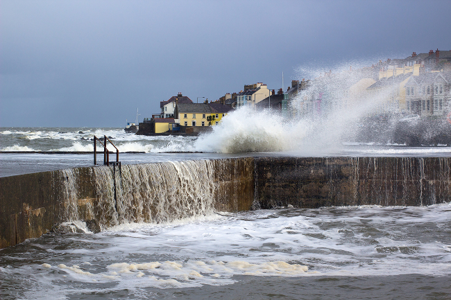
A yellow severe weather warning for wind has been issued for the whole of Northern Ireland and the west coast of England, Wales and southern Scotland. The warning is in force from 08:00 to 22:00 on Saturday. Gusts of 50-60 mph are expected quite widely within the warning area, with the possibility of 70 mph gusts in exposed coastal locations, especially in eastern Northern Ireland.
🚗 Take care if you are travelling on the roads today, particularly in the north, as strong winds could cause disruption and difficult driving conditions
— Met Office (@metoffice) April 6, 2024
Stay #WeatherAware ⚠️ pic.twitter.com/TBGI4OQkBo
Chief Meteorologist, Dan Suri, said: “Storm Kathleen will bring strong gusty winds to western areas of the UK through Saturday. Gusts of 50 to 60 mph are expected quite widely, while some exposed spots, particularly in coastal Northern Ireland, will see 60 to 70 mph gusts with large waves also expected.
“There will also be some blustery showers in the west with the eastern side of the UK seeing a drier and brighter day. With the winds coming from the south, some unseasonably warm air will be drawn across parts of the UK. When combined with sunny spells in East Anglia we could see temperatures reaching 21°C or 22°C for a time on Saturday. These temperatures are well above average for the time of year and the highest we’ve seen in the UK since last October.”
Advice for windy weather
With the Easter holidays in full flow, people out camping should be prepared for the unsettled weather, you can read top tips from the Scouts Association for camping in wet and windy weather on our website.
Windy weather can cause delays and make driving conditions dangerous, RAC Breakdown spokesperson Rod Dennis said: “This intense period of stormy weather is going to prove extremely challenging for anyone driving on the western side of the UK. We strongly urge drivers to avoid exposed coasts and higher routes where the impact of the very strong winds is most likely to be felt.
“It’s vital to slow down, keep a firm grip on the steering wheel at all times, and be prepared for the buffeting effect which can occur when overtaking high-sided vehicles. Leaving a much larger gap between vehicles also allows drivers to react quickly in the event of falling branches or flying debris.”
Weather next week
By Sunday the low pressure named Storm Kathleen will be to the northwest of the UK with gusts of around 50 mph still possible here at times though the day, winds will continue to ease from the south into the evening. Blustery showers will push north-eastwards across the UK through the day, with the southeast of England likely to be the driest and brightest region.
Low pressure will still be in charge of the UK’s weather through the beginning of next week with further wind and rain at times for many. From the middle of next week, there is a chance of drier conditions developing at times in the south, as high-pressure tries to build in. Elsewhere, conditions are likely to remain rather unsettled, although there will be a tendency for the heaviest and most prolonged spells of rain to become focused across northwestern areas.
You can keep up to date with the latest forecast on our website, by following us on Twitter and Facebook, as well as on our mobile app which is available for iPhone from the App store and for Android from the Google Play store.