A cold and bright Bank Holiday weekend
Author: Press Office
11:43 (UTC+1) on Thu 2 May 2019
Many of us will notice a marked difference in temperature between the up and coming May Bank Holiday weekend and the Easter weekend a couple of weeks ago.
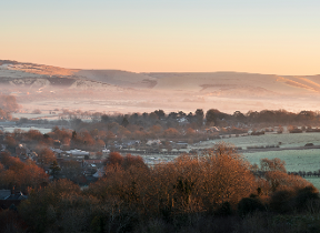
By the time we reach the weekend a cold air mass will cover the UK, bringing a dip in temperatures with some sharp night frosts likely. With high pressure to the west of the UK, western areas will see mostly settled conditions, whereas eastern areas, particularly the North East, will see more in the way of sunshine and showers.
Saturday will see a cold and frosty start for many with plenty of sunshine in the west, but windy and showery conditions in the east. There is a risk of heavy showers for the Midlands and South East, with a risk of hail, and some of the showers could be wintry over higher ground in the north. It will feel cold in the stronger winds.
Sunday will be generally dry away from the far North East where showers are expected to continue, and these are likely to spread southwards introducing more of a spilt by Monday, with showers in the North East and settled, dry weather in the South West.
Met Office Chief Meteorologist Andy Page said: “After cold, frosty starts and cool days for many across the Bank Holiday weekend, daytime temperatures will gradually recover early next week, however they will not come near the high values we saw over the Easter weekend.”
The RAC is warning that thirteen million leisure trips by car are expected to be taken this coming weekend, making it the busiest weekend in three years. RAC traffic spokesman Rod Dennis said; “The advice is to try to use the roads when they are quieter, which primarily means avoiding Friday afternoon and evening if possible, and setting off earlier on Saturday if possible, especially if travelling any great distance.”
He also warns: “The colder nights could be enough to cause problems with older car batteries – seriously disrupting plans for a getaway.”
After the Bank Holiday weekend, the weather is expected to become more unsettled, perhaps with spells of wet and windy weather across southern and central areas at times. Brighter conditions could remain in the far north, but there is still some uncertainty about exact locations and durations. Temperatures are expected to slowly increase to more typical values for the time of year, although it is likely to remain rather cold in the north for most of the coming week.
You can get the most accurate and up to date forecast for your area using our forecast pages and by following us on Twitter and Facebook, as well as using our mobile app which is available for iPhone from the App store and for Android from the Google Play store.
Updated at 11:46 (UTC+1) on Thu 2 May 2019