Storm Eunice continues ahead of unsettled weekend
Author: Press Office
16:09 (UTC) on Fri 18 Feb 2022
Significant impacts from Storm Eunice are still being felt across southern and central areas of the UK as the low-pressure system moves eastwards.
Red Warnings have now expired but continued disruption is expected with an Amber Warning for wind continuing until late on Friday evening.
Although the Red Weather Warnings have now expired, there is still a high impact Amber Weather Warning in force for Wales and many parts of England
— Met Office (@metoffice) February 18, 2022
This is valid until 21:00 Friday, with significant disruption still likely from #StormEunice
Stay #WeatherAware ⚠️ pic.twitter.com/AbWLLS5RzJ
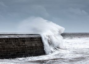
We are still seeing gusts in excess of 70 mph in places across England and Wales though overall winds are now easing from their earlier peak associated with Storm Eunice. Winds of this strength are likely to continue to damage buildings and trees with large waves around the coasts.
Met Office Chief Meteorologist Steve Ramsdale said: “Impacts will continue from Storm Eunice until late on Friday night, with continued high winds, especially in coastal areas.
“It's worth noting that despite the gradual easing of winds overall further impacts are likely from wind gusts continuing to reach 70 mph inland.”
The highest wind gust so far for Storm Eunice was 122mph at Needles on the Isle of Wight, although this is a particularly exposed station and is not representative of much of the wind seen elsewhere in the UK. This provisionally represents an England national record for highest one-off wind gust recorded. Elsewhere, the highest wind gusts for Storm Eunice have been provisionally reported as between 80mph and 90mph.
The Needles on the Isle of Wight recorded a wind gust of 122 mph this morning
— Met Office (@metoffice) February 18, 2022
This is provisionally the highest gust ever recorded in England#StormEunice ⚠️ pic.twitter.com/aNYMnFbMvT
National Highways Head of Road Safety, Jeremy Phillips, said: “We’re encouraging drivers to check the latest weather and travel conditions before setting off on journeys and consider if their journey is necessary and can be delayed until conditions improve. If you do intend to travel, then plan your trip and take extra care, allowing more time for your journey.
“In high winds, there’s a particular risk to lorries, caravans and motorbikes so we’d advise drivers of these vehicles to slow down.
“Drivers of other vehicles should be aware of sudden gusts of wind which can affect handling and braking, and give high-sided vehicles, caravans, and motorbikes plenty of space. In the event of persistent high winds we may need to close bridges to traffic for a period, so please be alert for warnings of closures and follow signed diversion routes.”
People are advised to check their local resilience authorities for ongoing safety advice around travel and preparations.
For more information on how to prepare for severe weather, please visit our WeatherReady advice.
Unsettled weekend
Following Storm Eunice’s departure out to the east late on Friday night, an unsettled weekend of weather is to come for many.
Yellow warnings have been issued through Saturday and Sunday, highlighting the ongoing risk of wind and rain, although much less impactful than Storm Eunice.
Met Office Chief Meteorologist Steve Ramsdale said: “Winds will decrease from their exceptionally high levels on Friday, but there’s a continued wet and windy theme for many through the weekend.
“The south will see wet and windy conditions on Saturday, before areas to the north and west, including Northern Ireland, see some more potentially disruptive conditions on Sunday. Weather warnings have been issued but should be checked throughout the weekend for any ongoing updates.”
Saturday’s yellow warning for wind covers much of the southwest, southern Wales and coastal areas in the south of England, where gusts of around 60mph are possible on the coasts, and around 40-50mph further inland. This will be accompanied by some persistent rain for many in the south, which will move eastwards as the day progresses.
Much of Scotland will enjoy a fine day on Saturday, although further rain will affect England and Wales with perhaps some snow across parts of the Midlands and southern Pennines.
However, wind and rain will be the main theme of Sunday for many in the north, with Yellow Weather Warnings issued.


