
Parallel Suite 47 (PS47) overview
An overview of the latest operational improvements to our modelling suite
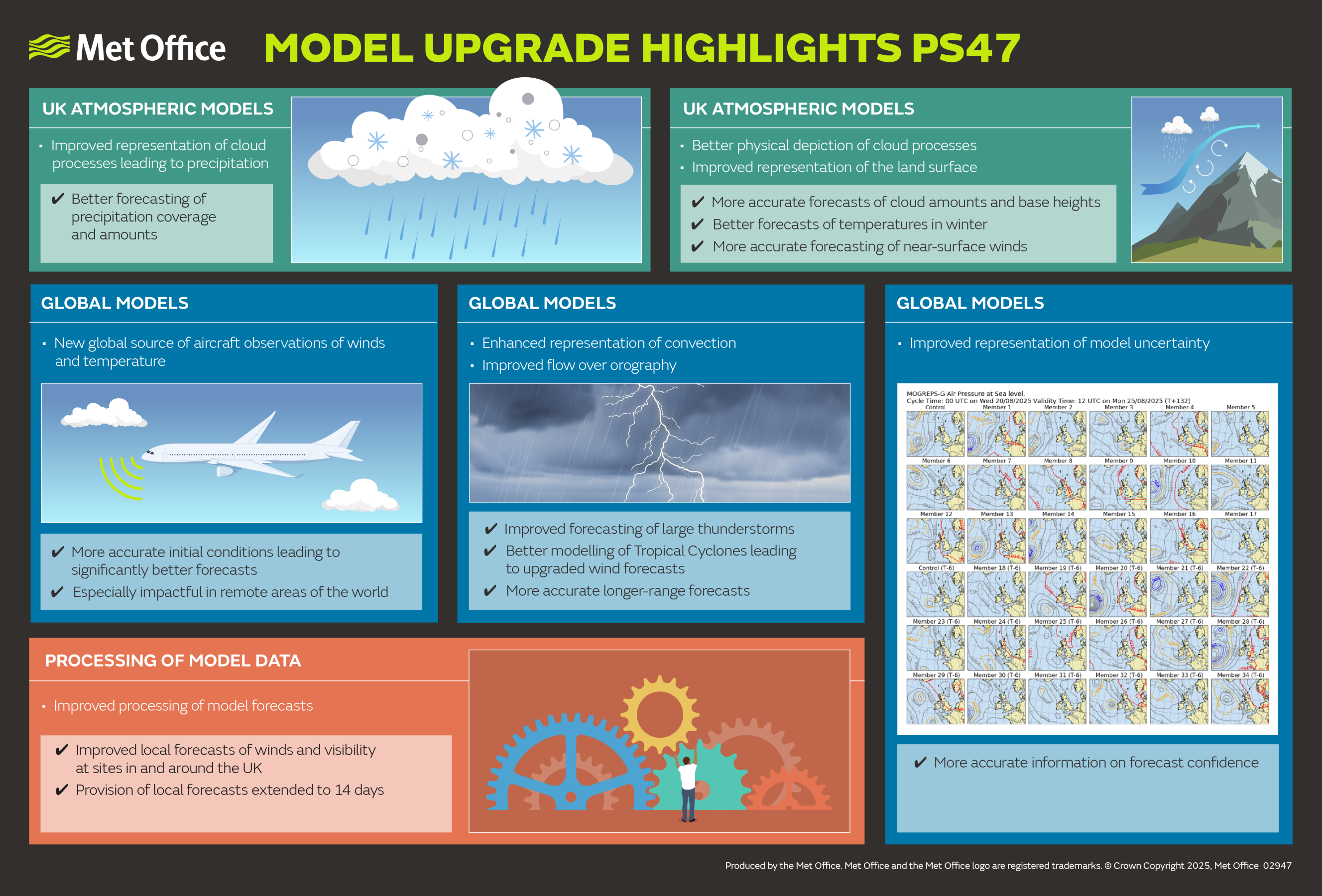
Overall summary
Parallel Suite 47 (PS47) represents the Met Office’s most significant science upgrade in more than three years, delivering a major step forward in the UK’s weather and climate modelling capability. This release provides substantial improvements across our global, regional, marine and postprocessing systems - enabling more accurate, reliable and useful forecasts for customers, partners and the public.
PS47 introduces upgrades to our core modelling systems (atmosphere, ocean, land and seasonal), improvements in postprocessing, enhanced data outputs, and the first operational components from the Next Generation Modelling System (NGMS).
Key improvements include:
- More accurate cloud and fog forecasts for the UK - particularly valuable for aviation.
- Improved winter temperature performance, supporting energy, transport and resilience planning.
- More realistic precipitation fields, improving usability for meteorologists and the public.
- Better tropical cyclone intensity predictions, helping to protect lives and livelihoods worldwide.
- Global ensemble forecast range extended to 10 days, enabling earlier alerts for high impact weather.
- Improved postprocessing, including 14day forecast feeds and upgraded visibility outputs.
- More comprehensive atmospheric datasets in the Standard Gridding Engine (StaGE), with reduced file sizes and improved data quality.
Download PDF of PS47 infographic
Global numerical weather prediction (NWP)
PS47 upgrades the global modelling system to GC5, introduces new aircraft observations via ModeS, updates ocean data assimilation, and replaces the global observation processing (OPS) to the new NGMS Jedi-based Joint Observation Processing Approach (JOPA) code.
Key improvements:
- Stronger performance in temperature, winds, convection and monsoon representation.
- More realistic tropical cyclones with deeper, better defined structures.
- Reduction in unrealistic precipitation “spikes”.
- Improved near surface temperature ranges.
- Global ensemble forecasts extended from 7 to 10 days.
UK regional models (UKV and MOGREPS UK)
PS47 introduces the Regional Atmosphere and Land 3 (RAL3) science package, updates data assimilation, and ensures closer alignment with the upgraded global model.
Key updates
- New double-moment microphysics scheme (CASIM).
- New bimodal cloud scheme.
- Enhanced boundary layer and land surface modelling.
- Improved radar data usage and visibility quality control.
- New stochastic perturbations for ensemble forecasts.
Benefits for users
- More accurate forecasts of temperature, cloud cover, cloud base and winds.
- More realistic light rain in frontal systems.
- Better winter temperature performance with reduced cold drift.
- Improved cloud base forecasts and reduced excessive low cloud.
Postprocessing (Met Office blended probabilistic forecast data)
Key improvements:
- Enhanced forecasts for end users, with improved wind gusts, wind speed, visibility and temperature.
- 14-day forecast data feeds for downstream systems.
Further detail
14day forecast test feeds including:
- 24 hour precipitation accumulation
- 24 hour precipitation fraction
- 24 hour sunshine duration
- Maximum screen level temperature (PT12H)
- Minimum screen level temperature (PT12H)
- 24 hour maximum wind gust
- Visibility calibration to address known NWP limitations.
Impact on forecast skill
SAMOS and visibility calibration deliver improved forecast skill across:
- Screen temperature
- Maximum temperature (T-max)
- Minimum temperature (T-min)
- Wind speed
- Wind gust speed
- Screen level visibility
Standard Gridding Engine (StaGE)
Enhancements have been made to the output of each atmospheric model, including new parameters, vertical levels, and timesteps. These improvements address user requirements, improve consistency and increase pull-through of supercomputing outputs which provides a richer, more comprehensive offering of data.
The impact of these will vary across different customer segments. Depending on the specific systems and data sources in use, some users may benefit from these improvements sooner or in greater detail than others. However, every effort is being made to extend these enhancements as widely as possible, so that all users benefit from the comprehensive data enhancements to our atmospheric model.
Key improvements:
- New parameters, vertical levels and time steps.
- Reduced precision to achieve smaller file sizes.
- Improved humidity consistency (specific humidity available across all models).
- Better coastal data quality via enhanced land–sea masking.
- Improved vertical interpolation for pressure level data.
- Corrections addressing unrealistic soil moisture and canopy water values.
Note to users
- Users receiving NetCDF via ServiceHub or MASS may need to adapt to updated levels and timesteps.
- GRIB2 users are largely unaffected, except for three global accumulation parameters.
Global marine models
Key improvements:
- Upgrade to the Global Ocean and Sea Ice (GOSI9) systems.
- Updated NEMOVAR data assimilation.
- Better forecasts for temperature, salinity and sea-level anomaly.
- Improved windflux handling for Global Wave.
- Wave forecasts extended to 7 days (no product changes yet).
Regional marine models
Key improvements:
- 7 day regional ocean forecasts.
- Updated fluxes, data assimilation and ecosystem modelling.
- More consistent boundary conditions (now from GOSI9).
- Reduced North Sea subsurface temperature bias.
- Updated wave model flux processing for improved coastal performance.
Seasonal forecasting (GloSea)
Key improvements:
- Upgrade to the GC5 seasonal configuration.
- New atmosphere, ocean, sea ice and land initialisation.
- New hindcast using ERA5 forcing.
- Improved Northern Hemisphere winter performance (with some statistical uncertainty).
Questions?
If you have questions, please don’t hesitate to contact us directly.