Met Office explains: How is thunder formed?
Thunder is one of nature’s most dramatic sounds, often accompanying the brilliant flash of lightning during a storm. But what causes this rumbling roar in the sky?
Thunder is one of nature’s most dramatic sounds, accompanying brilliant flashes of lightning during a storm. But what causes this rumbling roar in the sky? To understand thunder, we must first explore the processes that lead to its formation—starting with the clouds that produce it.
The role of cumulonimbus clouds
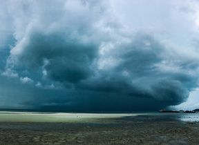
Thunderstorms are typically associated with cumulonimbus clouds—towering, dense formations with significant vertical development. These clouds often resemble mountains or vast towers and can spread out at the top into an anvil shape, especially when upper-level winds carry the cloud tops downwind.
Cumulonimbus clouds form through convection, where warm, moist air rises and cools, condensing into cloud droplets. Initially, these clouds may begin as cumulus, stratocumulus, or altocumulus, but as they grow and develop ice crystals at higher altitudes, they transition into cumulonimbus. This change is marked by a shift from a hard, domed top to a softer, fibrous outline.
Not all cumulonimbus clouds produce thunderstorms. Some may only bring heavy showers or hail. However, when lightning and thunder are observed, the cloud is classified as cumulonimbus by convention. These clouds are often referred to as “cloud factories” due to their ability to generate other cloud types, including cirrus, altostratus, and stratocumulus.
Typically, a single cumulonimbus cloud takes about an hour to form, mature, and dissipate. The thunder and lightning it produces usually last less than 30 minutes. Longer-lasting thunderstorms are often the result of multiple cumulonimbus clouds forming in succession or in clusters.
READ MORE: What is lightning and how does the Met Office monitor it?
Global distribution of thunderstorms
Thunderstorms occur across the globe, even in polar regions, although they are most frequent in tropical areas. The island of Java, for example, experiences thunderstorms on approximately 220 days each year, making it the most thundery location on Earth.
In temperate regions, thunderstorms are most common during spring and summer, though they can occur year-round, especially along cold fronts. In the UK, thunderstorm frequency varies significantly. Some areas may experience fewer than five thunderstorm days annually, while others, particularly in the east Midlands and southeast England, may see up to 20.
Seasonal variation is minimal along the western coast, but elsewhere in the UK, summer is typically the most thundery season. This variability means that maps showing thunderstorm frequency can differ depending on the period of record used.
What causes lightning?
Lightning is the precursor to thunder and forms within storm clouds through a complex process of charge separation. Inside a cumulonimbus cloud, strong updraughts carry tiny water droplets upward, where they freeze into ice. Some of these ice particles grow into hail, while others remain small.
As hail falls through the cloud, it collides with smaller ice particles, transferring electrons and creating a negative charge in the hail and a positive charge in the smaller ice particles. The updraughts continue to lift the positively charged particles, while the negatively charged hail descends, resulting in a separation of charges within the cloud.
This charge separation causes a buildup of negative charge at the cloud base, which repels electrons on the ground, leaving the surface positively charged. As the attraction between the cloud and ground intensifies, the insulating properties of the air break down, allowing electrons to surge downward at speeds of around 270,000 miles per hour. This flow of electrons constitutes an electrical current, which we observe as a flash of lightning.
LEARN ABOUT: Lightning
How thunder is produced
Thunder is the sound produced by lightning. When the electrical current from a lightning strike passes through the air, it heats the surrounding air rapidly—up to 30,000°C. This sudden heating causes the air to expand explosively, creating a shockwave that we hear as thunder.
The sound of thunder can vary depending on the distance from the lightning strike and atmospheric conditions. A sharp crack indicates a nearby strike, while a low rumble suggests the lightning occurred farther away.
Monitoring lightning with LEELA
The Met Office employs the LEELA (Lightning Electromagnetic Emission Location by Arrival time difference) system to monitor lightning. LEELA is an automatic lightning location network consisting of ten sensors positioned across Europe. This system detects pulses of radio waves, known as 'sferics,' emitted during lightning strikes at a very low frequency (VLF). These sferics travel great distances, reflected between the Earth's surface and the ionosphere, similar to light in a fiber optic cable.
To pinpoint the exact location of thunderstorms, LEELA uses a network of sensors that detect sferics at slightly different times. Through a technique called multi-lateration, the system calculates the arrival time difference (ATD) of sferics at each sensor, determining the precise location of the lightning stroke.
LEELA data is invaluable for identifying hazardous weather associated with thunderstorms, such as intense precipitation, severe icing, wind shear, turbulence, and strong wind gusts. This information is crucial for public safety, aviation, and other industries. LEELA provides continuous lightning data in Met Office bulletins, 24 hours a day, 365 days a year.
However, LEELA has some limitations:
- It does not yet discriminate between different types of lightning (e.g., in-cloud or cloud-to-ground).
- Its accuracy and sensitivity diminish at longer ranges.
- It does not cover the entire globe, with areas like Far East Asia, Russia, South East Asia, Australia, mainland USA, and the Pacific typically out of range.
- LEELA only reports the time and location of lightning strokes, not their intensity, polarity, or other attributes.
Despite these limitations, LEELA is a significant advancement in lightning detection, offering twice the detection capability of its predecessor, ATDnet, with comparable accuracy.
Keep up to date with weather warnings, and you can find the latest forecast on our website, on YouTube, by following us on X and Facebook, as well as on our mobile app which is available for iPhone from the App store and for Android from the Google Play store.


