Met Office daily weather: High temperatures and humidity return
High temperatures and humidity are back, with England and Wales set to experience the hottest conditions.
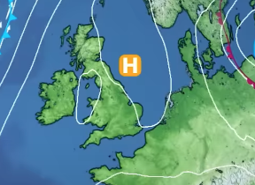
High temperatures and increasing humidity are back in the forecast this week. England and Wales are set to experience the hottest conditions, while Scotland and Northern Ireland face cloudier skies and occasional rain.
From today, rain will clear eastwards from the Northern Isles early in the day, giving way to dry conditions with sunny spells. Further rain, some of it heavy, will persist across western and northern Scotland before becoming confined to the far north later. Elsewhere, it will be largely dry and widely sunny, although scattered showers are expected in Northern Ireland, northern England and southern Scotland during the afternoon. There is a chance of heavier showers or thunderstorms developing in Northern Ireland and possibly northern England.
Cloud will increase from the south and southwest later in the day, bringing isolated showers, thunderstorms and gusty winds as it moves northeast. Temperatures will be near normal across northern and northwestern areas, but warm to very warm elsewhere, with locally hot conditions in central and southern England.
It is forecast to be a hot week ahead for parts of the UK, with the likely peak in temperatures coming on Tuesday 🌡️ pic.twitter.com/bFFiscjhTL
— Met Office (@metoffice) August 10, 2025
Rain will continue across the far north of Scotland, reaching Shetland later in the night, but will clear mainland Scotland by morning. Elsewhere, expect variable cloud and clear spells, with a scattering of showers and a chance of thunder across southern and central areas. It will remain warm in the south.
Outlook for Tuesday
Tuesday will begin with areas of cloud and showery rain, locally thundery, across central and southern regions. These will gradually move northeast, allowing increasing amounts of hot sunshine to develop across much of England and Wales by the afternoon. Scotland and Northern Ireland will remain generally cloudier, with early rain clearing the Northern Isles and leaving a few showers in its wake.
It will feel warm in the northwest, but very warm or hot elsewhere, with locally very hot conditions expected in central and western England and into Wales. Coastal areas will be kept cooler by sea breezes.
There is a very small chance of an isolated thunderstorm over central England and Wales in the evening. Otherwise, any showers further north will fade, leaving clear periods. Low cloud is expected in the far north, with a risk of low cloud, mist or fog forming in southern England.
Met Office presenter and meteorologist, Greg Dewhurst, said: “The fourth summer heat wave begins as temperatures rise quite widely across England and Wales in particular. Not quite as hot across parts of Northern Ireland and Scotland. The peak temperatures for the week ahead are possibly near the mid-30s over the next few days. A little less hot as we get towards the end of the week, but still well above average around 29 or 30°C.
“The average for this time of year should be nearer around 20 to 22°C, particularly across southern parts of the UK. High pressure sat to the southeast means we're drawing in hot and humid air over the next few days. But low pressure always near the north and the west. The risk of some rain at times and then an increasing risk of some thunderstorms perhaps by Tuesday as low pressure generally becomes a little bit more dominant.
“It's a bit of a north south split out there at the moment. Fairly cloudy skies. Northern Ireland, Northern England, parts of Scotland, outbreaks of rain. But the rain as we go through the day should be become increasingly confined to the Highlands and Islands particularly by the afternoon. England and Wales seeing plenty of dry weather, some hazy spells of sunshine, best of the blue skies across eastern and southeastern parts of England. But we are watching cloud gather from the southwest, parts of southwest England into Wales.
“The risk of one or two heavy showers or thunderstorms developing as we move through the day. It should be dry, but perhaps one or two showers possible across Northern England, Southern Scotland, Northern Ireland as we go through the day, but most places dry and those temperatures rising in that sunshine. The mid-20s locally, high 20s towards central southeastern parts. A peak around 30 to 31°C in the London area today. So, feeling quite hot out there.
“If you want some relief from the heat, the coast will be a little cooler and cooler conditions across the northwest of the UK. Generally, the low 20s here and high teens across the northwest of Scotland with outbreaks of rain continuing through the day into the evening time. The rain continues to push further north across northern Scotland reaching Orne late evening time and then overnight the continued risk of one or two thunderstorms, some showers developing. You might find that you see some lightning, you hear some thunder without any rain as the cloud is generally quite high levels, but most places will stay dry.
“The risk of some thunderstorms increases across Northern Ireland and Northern England, Southern Scotland into the early hours as well. And we'll see the continued push of hot and humid air northward. So, temperatures overnight will become increasingly warm, 15 to 16°C, minimums in places. Some places may be a little higher than this. So, it does start to become more uncomfortable for sleeping. Tuesday is going to be a mixed day. There is a risk of one or two lingering thunderstorms first thing. They continue to push northwards, but they become more isolated as the day goes on.
“There should be plenty of hazy sunshine across many parts. Early rain across Orne and Shetland will also clear. So, most places dry, but always the risk of one or two thunderstorms, perhaps northern England into eastern and southeastern parts of Scotland being at a higher risk, but they could pop up almost anywhere, particularly later on in the day. And in that sunshine, that strong sunshine, high UV levels, temperatures will really rise.
“We're looking at highs around 33°C across central and central southern parts of the UK. Cooler around the coasts at the mid locally high 20s and across the far northwest of Scotland. Temperatures in the low 20s possible here as well. Into the evening time on Tuesday, the risk of one or two thunderstorms in places. So, it is worth just staying up to date with the forecast, but lots of places will stay dry. And as I mentioned, the peak of the heat uh most likely on Tuesday and into Wednesday before just starting to ease a little but staying above average."