
Northern Ireland records third wettest Autumn on record, and Wales its tenth
Meteorological Autumn has been wet and mild, with temperatures and rainfall above average, according to provisional Met Office figures.
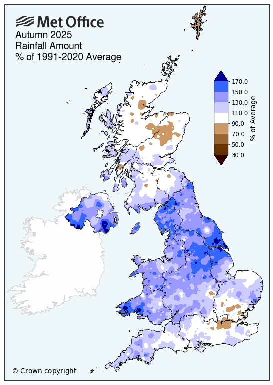
Northern Ireland has recorded its third wettest Autumn since the series began in 1836, and Wales its tenth. Autumn 2025 now stands as the only season of the year to report above average rainfall, with winter, spring and summer all below their respective long-term averages.
A very wet season for some
For Autumn, the UK recorded 20% more rainfall than the long-term meteorological average, but of the four nations, it was Northern Ireland and Wales that saw the most rainfall, with 39% and 37% above average respectively. Only 2000 and 2011 have seen wetter autumns in Northern Ireland since 1836.
England saw a clear north/south divide, with northern England recording 45% above average (its fifth wettest Autumn since 1836) and southern England 17% more than average.
The rainfall has been welcomed by some, following below-average rainfall for Winter 2024/25, Summer 2025 and an extremely dry Spring.
Met Office Senior Scientist Mike Kendon explained why it has been so wet: “Autumn is the time of year when we typically expect our weather to become more unsettled, with the resumption of a more active jet stream bringing Atlantic weather systems and associated rain. However, while this autumn has been notably wet in some areas, rainfall totals overall have not been exceptional.
“We’ve perhaps noticed the unsettled autumn weather all-the-more, because of the marked contrast from the prolonged spells of warm, dry, sunny weather we came to expect during spring and summer. For example, the UK rainfall total for autumn 2025 (403.4mm) is easily more than spring and summer combined (340.4mm).”
Despite the rainfall, parts of the country remain in drought conditions as we enter winter. Director of Water at the Environment Agency, Helen Wakeham, said: “Despite an improving picture and above average rainfall across much of England during the Autumn, we still need more rainfall through the winter in some areas to avoid a drought next year.
“Water companies must continue to quickly fix leaks and lead the way in saving water. We also urge everyone to be as efficient as possible with their water use this winter - even if it’s raining outside. Our wildlife, our rivers and our water supplies depend on it.”
Above average temperatures
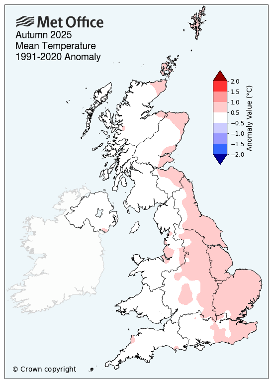
All seasons so far this year have seen above-average mean temperatures for the UK, with spring and summer the warmest on record. Autumn has continued the warm theme, though not record breaking. The UK reported a mean temperature of 0.4°C above the seasonal average, with England particularly warm.
Daily minimum temperatures (the lowest observed temperature for a 24-hour period between 0900UTC and 0900UTC) have also been well above average, with England recording its tenth highest average minimum temperature in the season.
Below average sunshine
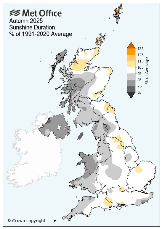
The UK recorded 5% below average sunshine for the season, with Northern Ireland particularly dull, seeing just 80% of its average sunshine. This was Northern Ireland’s fifth dullest autumn on record (series back to 1910), and its dullest since 1983.
Three storms across the autumn
Storm Amy was named on the first of October. The strongest winds were across north-western Scotland and Northen Ireland, gusting at over 80mph in exposed locations. A weather station at Magilligan, County Londonderry, recorded 80Kt (92mph) – a new Northern Ireland gust speed record for the month of October.
Storm Benjamin – named by Meteo France – brought heavy persistent rain and strong winds along the south coast towards the end of October, but the main impacts were across the near-continent.
Storm Claudia named by the Spanish Meteorological Service, brought persistent and extensive heavy rainfall just before mid-November. Parts of England and Wales received the whole-month November average rainfall, or more, in six days from 9th to 14th. The worst impacts were felt in South Wales, with Monmouth badly affected due to heavy rain across the River Monnow catchment (marking the England-Wales border), including the Black Mountains.
|
Provisional Autumn 2025 stats |
Mean temp (°C) |
Rainfall (mm/%) |
Sunshine (hours/ %) |
|||
|
Actual |
91/20 anom |
Actual |
91/20 anom |
Actual |
91/20 anom |
|
|
UK |
10.15 | 0.43 | 403.4 | 120 | 264.2 | 95 |
|
England |
11.07 | 0.51 | 320.6 | 128 | 301.6 | 98 |
|
Wales |
10.41 | 0.35 | 594.2 | 137 | 240.3 | 87 |
|
Scotland |
8.57 | 0.35 | 481.8 | 105 | 291.0 | 96 |
|
Northern Ireland |
9.98 | 0.35 | 449.2 | 139 | 203.3 | 80 |
November 2025: Very warm, then very cold, with well-above average rainfall
November’s temperatures and rainfall have been extremely variable across the month, concluding in above-average temperatures and sunshine, along with well-above average rainfall for some.
Well-above average rainfall
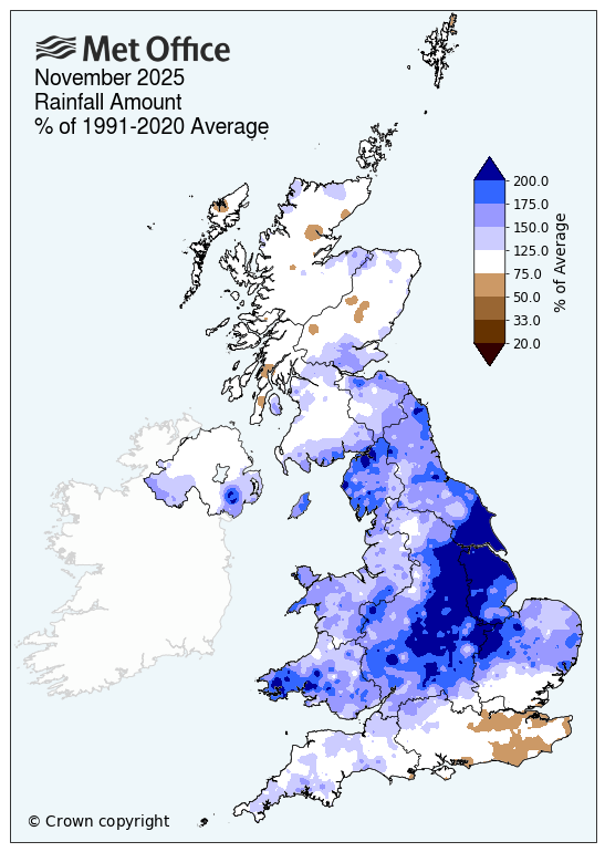
UK rainfall was 31% above average for the month overall. This makes November the third month of the year to have above average rainfall. In absolute terms, November has been the wettest month of 2025 so far with a provisional UK total of 162.1mm, over 40mm more than the next wettest (October, 121.2mm).
Wales and England have been especially wet, recording 59% and 49% above their November averages respectively. England has seen a clear north/south divide, with southern England recording 36% above average and northern England 71%, making it the fifth wettest November in the north of England since 1836. It's been notably wet across the Midlands and parts of Lincolnshire and Yorkshire, where some places have reported more than double their average November rainfall.
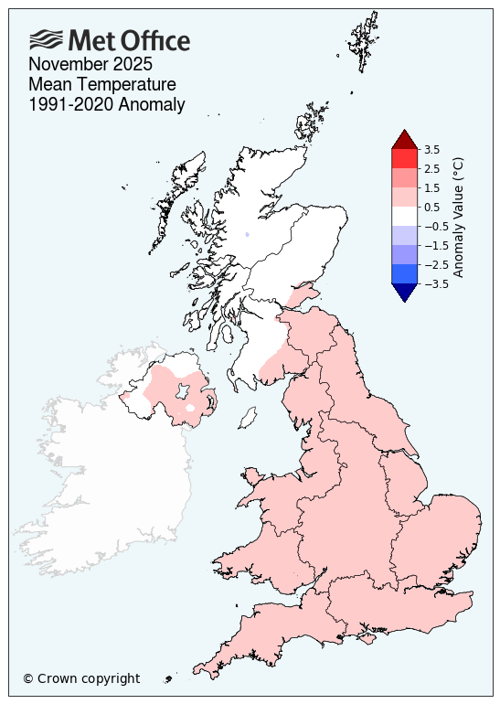
A month of two halves for temperatures
November started on a warm note, with a series of new high daily minimum temperature records across the UK, with dozens of weather stations reporting notable warmth. Temperatures however dropped following Storm Claudia due to a northerly influx of Arctic Maritime air, and hard frosts and snow were seen for some.
Overall, England recorded its tenth warmest November on record, with high daily maximum and minimum temperatures also.
Met Office Senior Scientist Mike Kendon said: “We saw large temperature swings during November, from extremely mild at the beginning, to a cold wintry spell in the middle and then very mild again. We recorded a daily minimum temperature of 14.8°C at Chivenor in Devon on the 5th. This is more than 8°C above the November 1991-2020 average for this station, and fairly close to the UK all-time record for the highest daily minimum temperature in November, which stands at 15.9°C in 2005.
“We then hit a daily minimum of -12.6°C at Tomintoul in Moray on 21st, which is the UK’s lowest November temperature since 2010. Although it is not exceptional to see temperatures as low as this in November, it does demonstrate the huge swings in temperatures that we have experienced as our weather patterns and air mass over the UK have changed during over the course of the month.”
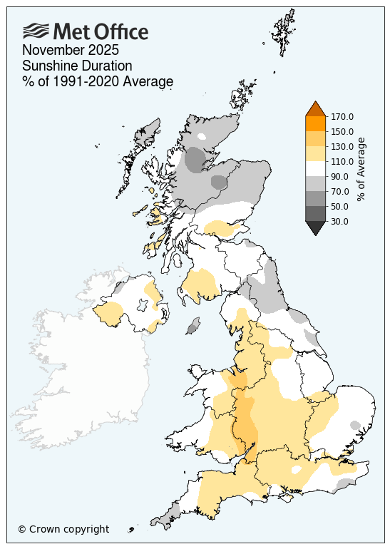
Just above-average sunshine
November sunshine hours were just above average for the UK (105%), with Wales particularly sunny (112%) and Scotland less so (93%).
So far this year, only the months of February and October have recorded below-average sunshine hours.
Read: November's historical weather records
|
Provisional November 2025 stats |
Mean temp (°C) |
Rainfall (mm/%) |
Sunshine (hours/ %) |
|||
|
Actual |
91/20 anom |
Actual |
91/20 anom |
Actual |
91/20 anom |
|
|
UK |
7.2 | 0.7 | 162.1 | 131 | 60.6 | 105 |
|
England |
8.2 | 1.1 | 137.5 | 149 | 70.5 | 109 |
|
Wales |
7.9 | 0.9 | 258.7 | 159 | 61.9 | 112 |
|
Scotland |
5.4 | 0.2 | 179.3 | 109 | 44.5 | 93 |
|
Northern Ireland |
7.2 | 0.5 | 149.2 | 122 | 57.3 | 105 |