Showers move into the south and west before settled conditions prevail next week
Showers, with possible thunderstorms, will move into the south and west of the UK for a time this weekend, before high pressure becomes re-established.
Through Friday high pressure will remain dominant across the UK, bringing another day of settled weather with plenty of warm sunshine across the country. It will be a warmer day than yesterday due to a reduction in cloud cover, especially in the far east and northeast where there will be less of an onshore breeze, with highs of 22°C possible in parts of Wales and the Midlands.
After another chilly night where an air frost is possible in eastern and southern Scotland, Northern Ireland and northern England, Saturday will be fine and dry with lots of sunshine. The exception being the far northwest of Scotland where a weak front will bring cloudier conditions with a chance of some light showers.
Temperatures will be warmer again than Friday, with low 20°Cs widely across the UK and highs reaching 24°C in eastern Wales, the Midlands, East Anglia and the south of England.
Low pressure brings the chance of showers and thunderstorms
A change in the outlook comes in on Saturday night. Most areas will remain dry with long clear spells under cloudless skies. The cloud will remain in the far northwest of Scotland and by the early hours of Sunday morning, cloud will increase in the southwest of the UK as an area of lower pressure moving north from the continent brings a risk of showers and possible thunderstorms overnight and into Sunday morning.
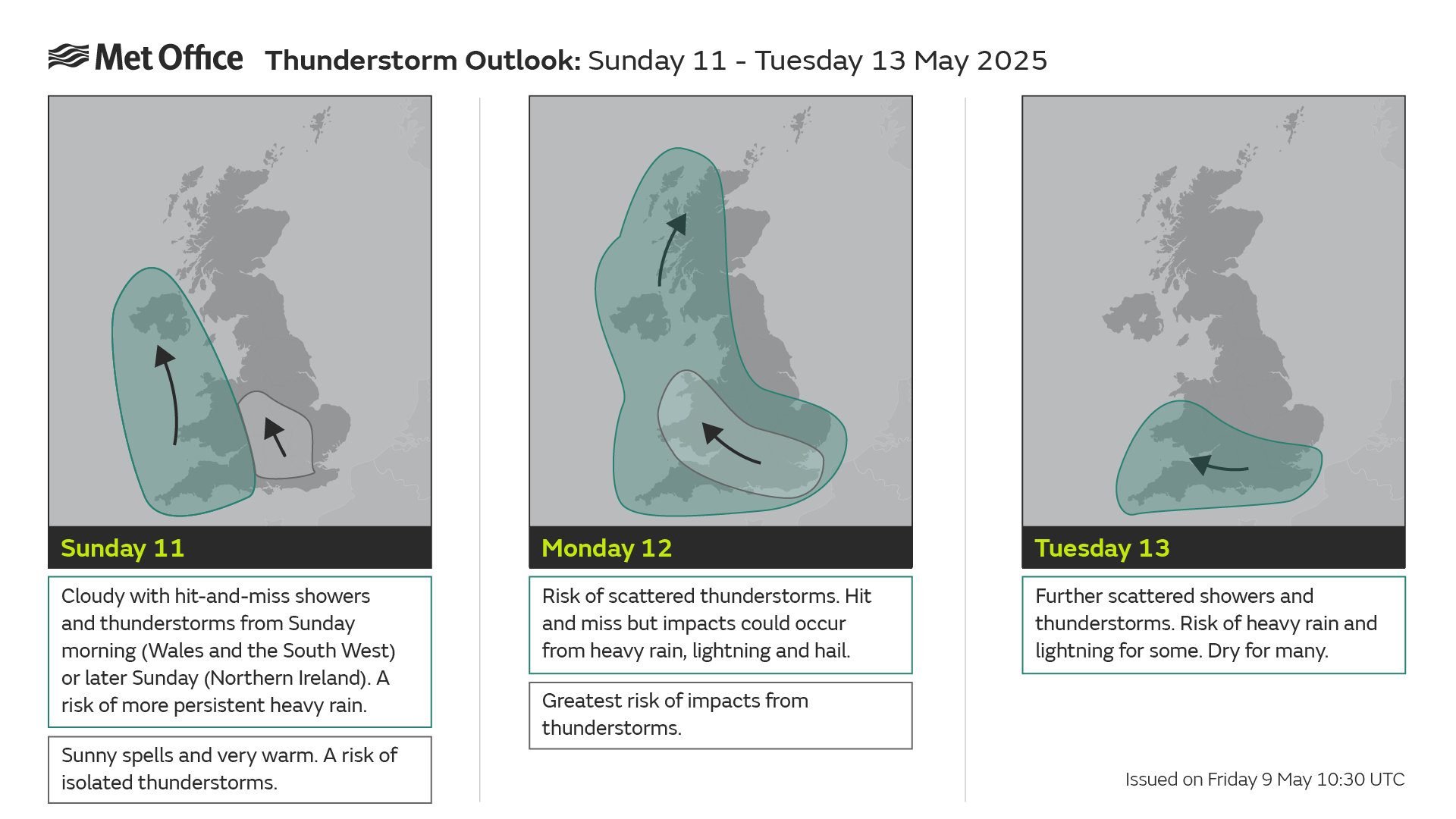
Met Office Deputy Chief Meteorologist, Dan Harris, said: “From Saturday night, into Sunday morning, there is an increasing chance of rain, showers and isolated thunderstorms moving northwards across the southwest of the UK. As we continue through Sunday and into Monday, this will extend to other western parts of Great Britain and into Northern Ireland too. On Monday itself, we could see some particularly vigorous thunderstorms developing, most likely in Wales and parts of southern England, whilst elsewhere during this whole period, dry, fine, and increasingly warm conditions are expected.
“Should these thunderstorms develop, especially on Monday, there is potential for 25-35mm of rain to fall in an hour or so which may lead to some localised surface water flooding. Hail, lightning, and isolated strong wind gusts would be additional hazards. Forecasting exactly where thunderstorms will form at this range is fraught with uncertainty, so please stay up to date with the Met Office forecast through the weekend, and any severe weather warnings which may be issued.”
In the sunshine, away from the cloud in the west and southwest, temperatures will likely build again, with highs of 26-27°C possible on Sunday and Monday.
Next week’s weather
The chance of showers persists into Tuesday across the far south of the UK, with higher pressure once again becoming dominant and eventually clearing the showers away. Much of the UK will have another bright sunny day on Tuesday, with the settled conditions covering the vast majority of the UK by Wednesday and likely to remain through the week.
Keep up to date with weather warnings, and you can find the latest forecast on our website, on YouTube, by following us on X and Facebook, as well as on our mobile app which is available for iPhone from the App store and for Android from the Google Play store.