Storm Goretti to bring very strong winds, heavy snowfall and rain
A deep area of low pressure crossing the south of the UK will bring a ‘multi-hazard’ event through Thursday and into Friday.
An Amber warning for wind has been issued for the west of Cornwall and the Isles of Scilly where potentially exceptionally strong winds could cause significant impacts. An Amber warning for snow has been issued for most of Wales, the Midlands and southern parts of northern England. Numerous Yellow warnings for wind, snow and rain have also been issued across different regions of England and Wales.
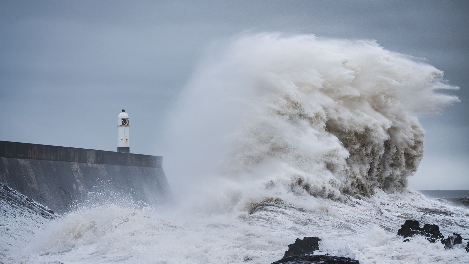
The strongest winds in the UK associated with this system are expected to affect the west of Cornwall and the Isles of Scilly where gusts could reach up to 100mph in exposed coastal locations where the Amber warning is in force. Very large waves will bring dangerous conditions to coastal areas. These are exceptional wind speeds and could be stronger than other storms in recent memory such as Storm Ciaran in 2023 and Storm Eunice in 2022. Strong winds, with gusts of 50-60 mph, will affect the far southwest of Wales and other parts of southern England, especially exposed coasts and hills.
Even stronger winds from Storm Goretti are expected in the Channel Islands and northern France, which is why the storm has been named by Météo-France and does not use a storm name from the Met Office storm list.
Storm Goretti is also expected to bring a spell of snow, with the largest snowfalls most likely to be across Wales and parts of the Midlands, where a further Amber warning has been issued. Rain will be an additional hazard, particularly for parts of southwest Wales and eastern England as Goretti moves through.
Met Office Chief Forecaster Neil Armstrong said: “Storm Goretti will be a multi-hazard event, with the most significant impacts from snow in parts of Wales and the Midlands and the very strong winds in the far southwest, though heavy rain in some parts of Wales and East Anglia also has the potential to bring disruption to many.
“Goretti will bring snow on its northern edge, this most likely over Wales and the Midlands. Here accumulations of 10-15 cm are likely widely, with 20-30 cm possible in some places, especially higher ground in Wales and the Peak District. An Amber warning has been issued where the greatest risk of disruption is likely on Thursday night into Friday morning. This is a complex spell of severe weather and I’d advise people in the warning areas to keep up to date with the forecast and messages from local authorities.”
⚠️⚠️ Amber weather warning UPDATED ⚠️⚠️
— Met Office (@metoffice) January 8, 2026
Very strong winds for the Isles of Scilly and parts of Cornwall
Thursday 16:00 – 23:00
Latest info 👉 https://t.co/QwDLMfRBfs
Stay #WeatherAware ⚠️ pic.twitter.com/4kTqbdbNP2
Further north, cold conditions persist with a continued risk of snow and ice. Thursday and Friday will be more settled days across Scotland, Northern Ireland and the far north of England with some coastal wintry showers but brighter and drier conditions inland. Temperatures fell to -14.7°C at Tomintoul, Banffshire, overnight last night. Temperatures will once again drop overnight, widely falling below freezing and lows of -12°C or lower possible in areas of lying snow. Further warnings are likely to be issued for the continued wintry conditions.
In addition to the severe weather warnings, UKHSA Amber cold weather health alerts are in place for all regions of England until 12 January.
Advice on staying safe in severe weather
With multiple types of severe weather impacting the UK over the next couple of days, the Met Office’s WeatherReady campaign offers practical advice to help you prepare your home, garden, and daily routines for winter weather.
Snow and ice warnings are in place for several regions ❄️⚠️
— Met Office (@metoffice) January 7, 2026
There are some simple steps that you can take to keep safe and be #WeatherReady - whether you’re staying home or heading out and about 🚗
Check them out here 👉 https://t.co/uVDoAfOk4U
Disruption from severe weather
Met Office weather warnings highlight the potential for travel disruption, with train and bus routes likely affected, as well as tricky conditions on many roads. Rain is another disruptive factor for many in the south of England, particularly on Thursday night and into Friday morning.
RAC breakdown spokesperson Alice Simpson said: “These relatively rare amber weather warnings for snow must be heeded by drivers. They're clear signs that disruption is likely across a large swathe of Wales and central England, and possible over a much greater area of the UK. People may want to consider avoiding driving overnight from Thursday into Friday or bringing journeys forward to avoid being stuck in the worst weather.
"These aren’t conditions anyone wants to be caught out in, so those who have to drive need to be confident on potentially slippery surfaces, have ensured their vehicles are up to the task, and are carrying an emergency breakdown kit so they can stay warm and communicate easily should they get stuck or break down.”
Weekend weather forecast
Storm Goretti’s influence will wane on Friday evening as the system moves to the east of England. There will be a short-lived interlude of calmer weather for many on Saturday with rain showers easing, cloud for those in the east, and sunny spells possible elsewhere.
However, by Sunday further unsettled weather will move in from the west. As milder Atlantic air tries to displace the cold air over the UK it brings a risk of some further widespread snowfall and strong winds in the north of the UK and rain further south. There is still some uncertainty in the detail for the second part of the weekend so it’s important to stay up to date with the forecast.
The current outlook for next week is for the milder air to push across the UK, ending this current spell of cold weather and opening the door to temperatures closer to average for the time of year as well as further areas of low pressure bringing wet and windy spells from the west.
You can find the latest forecast on our website, on YouTube, by following us on X and Facebook, as well as on our mobile app which is available for iPhone from the App store and for Android from the Google Play store.