Cold and unsettled weather for many
Author: Press Office
11:40 (UTC+1) on Wed 30 Mar 2022
A spell of unsettled weather is on the way for much of the country this week, with rain showers and a possible mix of sleet and snow, mainly on high ground in the north.
There will be a noticeable change from the dry and mild weather associated with the high-pressure system which dominated the country last week, with colder Arctic air pushing south across most of the country. This brings with it the risk of unsettled conditions for many for the rest of the week.
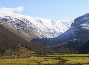
A Yellow Warning for ice has been issued for northeastern areas of the UK, with the potential for widespread icy patches. Linked to this, a band of wintry showers will sink south through Wednesday, bringing a continued risk of snow to high ground, and a mix of rain, sleet and snow to lower levels. Some accumulations may be expected over higher ground, but any slight accumulations at lower levels are unlikely to hang around for too long.
⚠️ Yellow Weather Warning issued ⚠️
— Met Office (@metoffice) March 30, 2022
Ice across eastern Scotland and northeast England
Wednesday 2000 – Thursday 1000
Latest info 👉 https://t.co/QwDLMfRBfs
Stay #WeatherAware pic.twitter.com/TTgFPALi4b
The cold front continues to push south, with the risk of wintry precipitation persisting, before eventually clearing southern areas early on Thursday. Overnight in the southeast, there may be some temporary accumulations, mainly over higher ground, but potentially briefly to lower levels. If it does manage to settle it will most likely be on grassy surfaces, with road temperatures having built up sufficiently in the recent mild weather to avoid any significant issues.
Behind this, wintry showers follow for many areas through Thursday and Friday, especially northern and eastern areas. Snow becomes increasingly confined to higher ground, with rain more likely at low levels, although an odd flurry of sleet or snow can’t be ruled out.
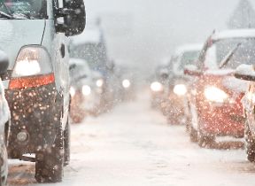
Coupled with the sleet and snow is the drop in temperatures that many places have already been experiencing. Isolated rural areas in the north of Scotland could see temperatures as low as –8C later in the week, with sub-zero temperatures possible overnight for much of the UK.
The unsettled theme will continue through the weekend, although temperatures will gradually recover to near-average over the weekend and into the start of next week.
Met Office Deputy Chief Meteorologist Helen Caughey said, “Cold and unsettled weather takes charge over much of the UK this week, as cold air is drawn in from the north, bringing with it the risk of rain, sleet and snow, and a widespread drop in temperatures.
“Although there’s still some uncertainty on the exact location of snow showers, the trend is for a mix of sleet and snow to fall as a cold front moves south through on Wednesday, before clearing southern areas on Thursday morning, with the main areas at risk of snowfall being higher ground in the north and east. The best of any clear and sunny spells through the rest of this week are likely to be in the south and west of the UK, albeit feeling colder compared to last week.”
The drop in temperatures is a risk for some of the nation’s gardeners. The Royal Horticultural Society’s Guy Barter said: “Colder weather will slow plant growth and inhibit plums and pears pollination as insects fly less in cold dull weather.
“Limited rain will help new sowings of peas and carrots for example and newly planted lettuces and other plants but should not greatly delay sowing and planting once conditions improve. Tender plants, petunias and tomatoes for example, won’t be put outside for another month at least but lower light affects greenhouses and will slow their growth.”
You can check the latest forecast on our website, by following us on Twitter and Facebook, as well as on our mobile app which is available for iPhone from the App store and for Android from the Google Play store. Keep track of current weather warnings on the weather warning page.