Amber snow warning for parts of Scotland
Author: Press Office
08:04 (UTC) on Fri 16 Dec 2022
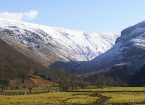
Snow moving eastwards across Scotland today will see 5 to 10 cm accumulating down to low levels quite quickly in places this morning through parts of the central belt.
An Amber warning has been issued valid until 12 noon today, although across the southern part of the warning area the snow has now begun to turn to rain at low levels. Therefore the worst of the conditions from now on look like being across the higher parts, just north of the Forth-Clyde valley. There is also a yellow warning for snow and ice covering a much wider area, valid until 9pm this evening. There is some concern that sleet, or rain may fall onto frozen surfaces, leading to icy conditions in some areas.
⚠️⚠️ Amber weather warning issued ⚠️⚠️
— Met Office (@metoffice) December 16, 2022
Snow across central parts of Scotland
Friday 0500 – 1200
Latest info 👉 https://t.co/QwDLMfRBfs
Stay #WeatherAware ⚠️ pic.twitter.com/NsoyspRjkq
A number of other yellow National Severe Weather warnings for snow, ice and wind are either in place or will be issued over the coming days. The UK will remain cold into the weekend with the risk of sleet and snow at times continuing mainly across northern areas.
Met Office Chief Forecaster, Frank Saunders, said: “The UK will remain in a northerly airflow until the weekend but then the cold conditions, which have dominated our weather patterns will start to lose ground to a push of mild air from the southwest – but not without problems in the transition period. As the mild air meets the cold air currently in situ over the UK there will be a transient spell of snow, even to low levels, especially in the north. Add to this the risk of rain falling onto frozen surfaces, and strong winds over upland areas of northern Britain (bringing blizzard conditions briefly), and this could be a day to avoid travelling in some areas, although the snow should turn to rain later.”
Sunday will see the start of a marked change in weather type. It will remain unsettled into next week, perhaps with a trend down in temperatures once again, although not as cold as we are currently experiencing. We could potentially see a return of some wintery hazards but with a lot of uncertainty in how prolonged this might be and what associated hazards it might bring. Strong winds could prove disruptive at times in the first half of the week.
A Level 3 Cold Weather Alert has been issued by the UK Health Security Agency (UKHSA) covering all of England and is currently in place until 12 noon on Sunday 18 December.
Cold-weather advice
There is lots of advice on the Met Office website on how to prepare for cold weather. Dr Agostinho Sousa, Consultant in Public Health Medicine at UKHSA, said: “Cold weather can have serious consequences for health, and older people and those with heart or lung conditions can be particularly at risk.
“If you have a pre-existing medical condition, you should heat your home to a temperature that is comfortable for you. In rooms you mostly use such as the living room or bedroom, try to heat them to at least 18°C if you can. Keep your bedroom windows closed at night. Wearing several layers of clothing will keep you warmer than one thicker layer.”
Douglas Cairns, Traffic Scotland Operator Manager, said: “We are urging travellers to plan ahead and check before they leave, and also to ensure their vehicles are winter ready.
“Planning ahead has never been more important. Here, our winter treatment plans are already well underway across the trunk road network, salt barns are well stocked and a record 240 gritters are ready for deployment from over 40 depots across Scotland.
“We expect the transport network to be busier in the run up to the Christmas weekend as people look to spend time with friends and family, so it’s important that travellers continue to play their part.”
Traffic Scotland has lots of advice on its website around travelling in severe weather conditions, visit their 'Are you ready for Winter' web page.
You can check the latest forecast on our website, by following us on Twitter and Facebook, as well as on our mobile app which is available for iPhone from the App store and for Android from the Google Play store. Keep track of current weather warnings on the weather warning page.
Updated at 08:04 (UTC) on Fri 16 Dec 2022