
Thundery downpours ahead of unsettled weather
Author: Press Office
12:05 (UTC+1) on Wed 8 Jun 2022
Parts of Northeastern England and southern Scotland will see thundery downpours today (Wednesday), with further unsettled weather expected for most through to the end of the week.
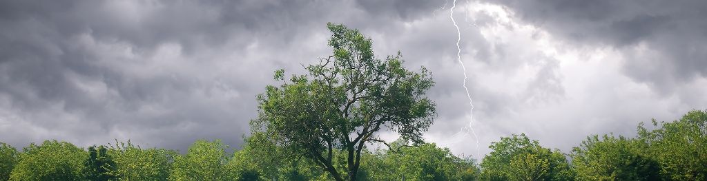
The first of two upcoming low-pressure systems is sat over northern areas of the UK today, bringing with it some thundery downpours, especially for those in northeast England and southern Scotland. A Yellow Weather Warning for thunderstorms has been issued, and although some areas will miss the worst of the showers, in excess of 30mm of rain is possible within a couple of hours for some locations within the warning area. The warning is valid from 13:00 to 20:00 today (Wednesday).
⚠️ Yellow weather warning issued ⚠️
— Met Office (@metoffice) June 8, 2022
Thunderstorms across S Scotland and NE England
Wednesday 1300 – 2000
Latest info 👉 https://t.co/QwDLMfRBfs
Stay #WeatherAware⚠️ pic.twitter.com/kSSNUp1ZYU
Met Office Chief Meteorologist Steve Willington said: “Slow-moving thundery showers are the driving force behind the weather warning that has been issued. There’s a chance of some accompanying lightning and hail, and there could be some difficult driving conditions with a small chance of some localised surface-water flooding due to the volume of rain in a relatively short period of time.
“Some places within the warning area will miss the heaviest of the showers, but isolated spots could see in excess of 30mm of rain in just a few hours.”
Wet and windy weather to come
The unsettled theme is to continue for most later this week when the remnants of Ex-Tropical Storm Alex, which brought heavy rain to southern Florida earlier on, tracks to the northwest of the UK and will bring with it some strong winds and showers.
Met Office Deputy Chief Meteorologist Rebekah Sherwin said: “By the time the system that was Tropical Storm Alex gets near UK shores, it will have transitioned into a mature Atlantic low. Although no longer a named storm, it will bring some unseasonably strong winds across the northern half of the UK – especially to the northwest on Friday and Saturday.
“The track of the low-pressure system currently looks to be grazing the far northwest of the UK on Friday and Saturday and, although the details are still being worked out, winds are likely to reach around 45mph for many areas in the north of the UK, with a chance of some gusts in excess of 55mph in some exposed northwestern island and coastal areas.”
Along with the wind, northwestern areas will see frequent showers on Friday and Saturday, some of which are likely to be heavy and thundery. Both wind and showers are expected to ease on Sunday. With the focus of both in the northwest, southern parts of the UK will stay mostly fine through the weekend, with sunny periods and lighter winds.
You can check the latest forecast on our website, by following us on Twitter and Facebook, as well as on our mobile app which is available for iPhone from the App store and for Android from the Google Play store. Keep track of current weather warnings on the weather warning page.