Weather for the Coronation
Author: Press Office
11:58 (UTC+1) on Fri 5 May 2023
The weather forecast for the Coronation of Their Majesties King Charles III and Queen Camilla.
The unsettled weather will continue across the UK into the weekend.
Saturday will be another cloudy, wet day for many. Showers are likely to develop in central, eastern, and northern areas, as well as across Northern Ireland, but they are not expected to be as intense or as heavy as those on Friday.
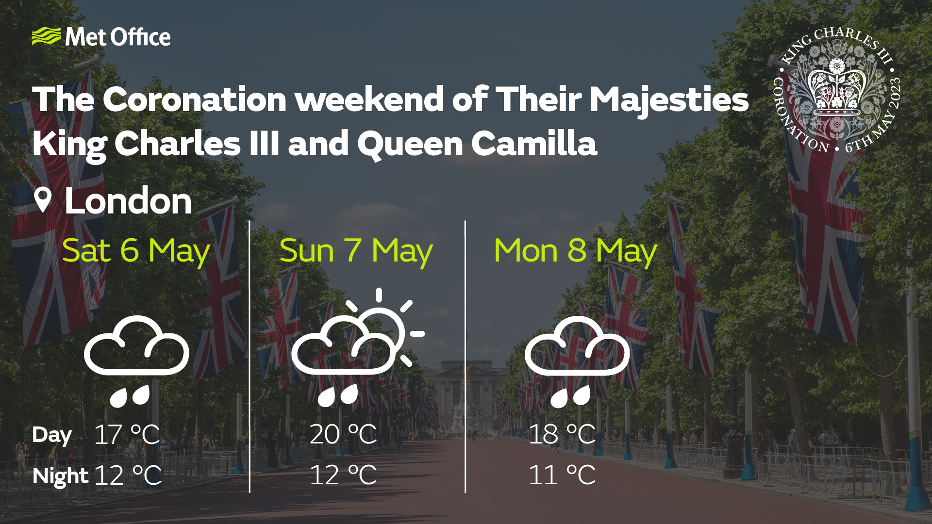
Met Office Chief Meteorologist Matthew Lehnert said: “An area of rain is expected to move into southwest England early on Saturday, moving northeast through the day with some heavy bursts at times. This is likely to bring some rain to London from mid-morning. Further north in Scotland, northern England and Northern Ireland it will be a day of sunshine and showers before the more persistent rain moves northwards overnight. Under the cloud and rain, temperatures will be subdued with 16 °C in London, whilst 20 °C is likely in sunnier northwest Scotland.”
Further ahead
With celebrations continuing through the bank holiday, Sunday will start off dry and bright in many western areas, but cloudier with some rain and drizzle in the east. Western and central parts of the UK are expected to have a mainly fine, warm and dry day with sunny spells, which will eventually spread to all areas. However, before it does, the early cloud and rain in the east may in some parts, particularly east and southeast England, break out into slow moving heavy and locally thundery downpours. Parts of northeast England and eastern Scotland could remain fairly grey, wet and cool throughout.
Eastern areas will start out mostly dry but quite cloudy or murky on Monday, but an area of heavy rain and showers in the west will sweep eastwards throughout the day bringing rain eventually to most places. The far north of Scotland has the best chance of a drier, and warmer, day. Drier weather will follow into the west later, although it is likely to remain cloudy with some patchy rain or drizzle, especially on hills. Winds are expected to be moderate or fresh with temperatures near average.
The rest of next week remains unsettled with the risk of more heavy showers and thundery outbreaks, particularly for Tuesday and Wednesday.
Weather over past Coronations
Data from the Met Office archive shows that past coronations back to Edward VII have been mixed when it comes to the weather. The Coronation of HM Queen Elizabeth II saw temperature highs of just 11.8°C on 2 June 1953 with some light rain through the day. The Coronation of HM King George V was the mildest of the last four monarch’s Coronation, with daytime highs of 17°C on 22 June 1911.
|
Coronation |
Date |
Daily max temp (°C) |
Daily min temp (°C) |
Daily rain (mm) |
Daily sunshine (hours) |
|
Edward VII |
09/08/1902 |
16 |
9.1 |
0.5 |
- |
|
George V |
22/06/1911 |
17 |
12.8 |
0.3 |
0 |
|
George VI |
12/05/1937 |
14.2 |
6.2 |
8.2 |
0 |
|
Elizabeth II |
02/06/1953 |
11.8 |
6.8 |
2.6 |
1.2 |
We will continue to update the forecast here on our website and on our mobile app, which is available for iPhone from the App store and for Android from the Google Play store. Keep up with the latest on our social media accounts on Twitter and Facebook. Any weather warnings will be posted on the weather warning page.