Met Office daily weather: A change is on the way after this week's early heat
The UK is set to experience a shift in weather conditions midweek, with a cooler and more unsettled pattern developing in some areas.
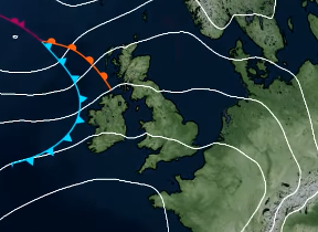
A band of thicker cloud will develop across the southeast during the day, bringing outbreaks of rain. There is a small chance of this turning thundery in the far southeast before clearing later in the afternoon. Eastern Scotland and northeastern England will begin the day cloudy, with showers continuing from overnight. These showers may become locally heavy with a risk of thunder before gradually moving offshore during the afternoon.
Elsewhere, sunny spells are expected, although showers will develop across Northern Ireland and Scotland. These may be heavy at times but will ease into the evening. Temperatures will be markedly lower in the southeast compared to recent days, though maxima will still reach the low to mid-20s Celsius across much of England and Wales, with isolated peaks of 26–27°C in the southeast. Scotland and Northern Ireland will see highs in the low 20s.
After a very hot day for some today, it will be turning fresher for all by Wednesday 📉
— Met Office (@metoffice) July 1, 2025
Remaining changeable through the week, especially in the northwest, where we could see some wet and windy conditions on Friday ☔ pic.twitter.com/7VZBUFG1Fu
By mid to late afternoon, dewpoints will fall significantly across most areas, except along North Sea coasts and the far southeast, leading to a fresher feel.
Showers will fade across Northern Ireland and most of Scotland, leaving a largely dry night with clear spells. However, cloud will increase in the northwest, bringing outbreaks of rain to western Scotland by dawn. A fresher night is expected across the southeast, with temperatures falling more widely than in recent nights.
Outlook for Thursday
A distinct northwest–southeast split will emerge. The southern two-thirds of the UK will remain settled and dry, with rather warm conditions and some fair-weather cloud during the day. In contrast, the northwestern third will turn more unsettled, with near-average temperatures, increased cloud cover, and scattered showers. Isolated thunderstorms are possible during the afternoon, particularly in northeastern Scotland. Showers will be most frequent over the hills of western Scotland. Winds will strengthen later in the day as further rain approaches from the west.
READ MORE: Record-breaking June 2025 weather stats: A regional breakdown
Met Office presenter and meteorologist, Alex Burkill, said: “There will be some heavy rain at times in the east and that could cause a little bit of problems in a few places because there could be some thunder mixed in with it. The heavy rain that's pushing into parts of the southeast, Kent, East Anglia, for example, some thunder possible there, and also further north across parts of eastern England, maybe even the far southeast of Scotland could see some thunder as well.
“Otherwise, there will be a scattering of showers coming in across parts of Scotland to Northern Ireland, some sunny spells mixed in, but yes, some fairly hefty showers possible. And otherwise, across the bulk of England and Wales, it's looking like a largely fine day, some decent sunshine on offer and feeling pretty warm in that sunshine too. Temperatures nowhere near as high as they have been of late, we're looking at highest temperatures probably around 25, 26°C, so yes, feeling warm but not as oppressively hot as it has been."
Keep up to date with weather warnings, and you can find the latest forecast on our website, on YouTube, by following us on X and Facebook, as well as on our mobile app which is available for iPhone from the App store and for Android from the Google Play store.


