New Climate Data Portal makes data more accessible
Author: Press Office
09:00 (UTC+1) on Thu 29 Jun 2023
A new data portal enables users to understand local and national impacts from climate change.
The Met Office’s Climate Data Portal has gone live today, giving organisations improved access to climate data and other resources, allowing them to better understand and respond to climate change.
Built using geospatial technology from Esri UK, the free resources make it easier for businesses or government organisations to combine open climate data with their own data and reveal the future impact of extreme conditions on their operations, including heatwaves, floods or droughts. The project is part of the strategic partnership between the Met Office and Esri UK who have been working together for over 20 years.
The project is part of the Hadley Centre Climate Programme (HCCP) and is, in part, funded by DSIT (Department for Science Innovation and Technology) and supports the work of DESNZ (Department for Energy Security and Net Zero) and other UK Government departments.
Combining Met Office expertise and authoritative data with Esri’s geospatial tools, the portal presents complex scientific climate projections in easy-to-use formats, ready to visualise and analyse in GIS and non-spatial applications or integrate into business processes for improved decision making. Spatial analysis can be performed at a global, regional or local level enabling location-specific action plans to be developed.
More accessible formats
The Climate Data Portal also makes it easy to export datasets in easy-to-use formats, this enables easy use in other tools that you may already be using.
“Historically, climate science has defined the problem, now it’s moving to help with the solution, providing information at a local level which is highly relevant to UK organisations,” explained Professor Jason Lowe OBE, Head of Climate Services at the Met Office.
“By combining the Met Office’s latest projections with Esri’s geospatial tools, the reach and value of this data is greatly extended. UK stakeholders can investigate their physical climate risks over the next 50 to 100 years. The most detailed climate projections reveal a greater chance of warmer, wetter winters and hotter, drier summers and these help users plan and prepare for extreme weather, climate change and the reporting which new regulations, linked to climate change, will require.”
Data in the hands of those that need it
Part of the Met Office’s wider strategy is to maximise accessibility to Met Office data to get our essential weather and climate data into the hands of those that need it. The Met Office Climate Data Portal contains over 60 different data layers, guidance and applications.
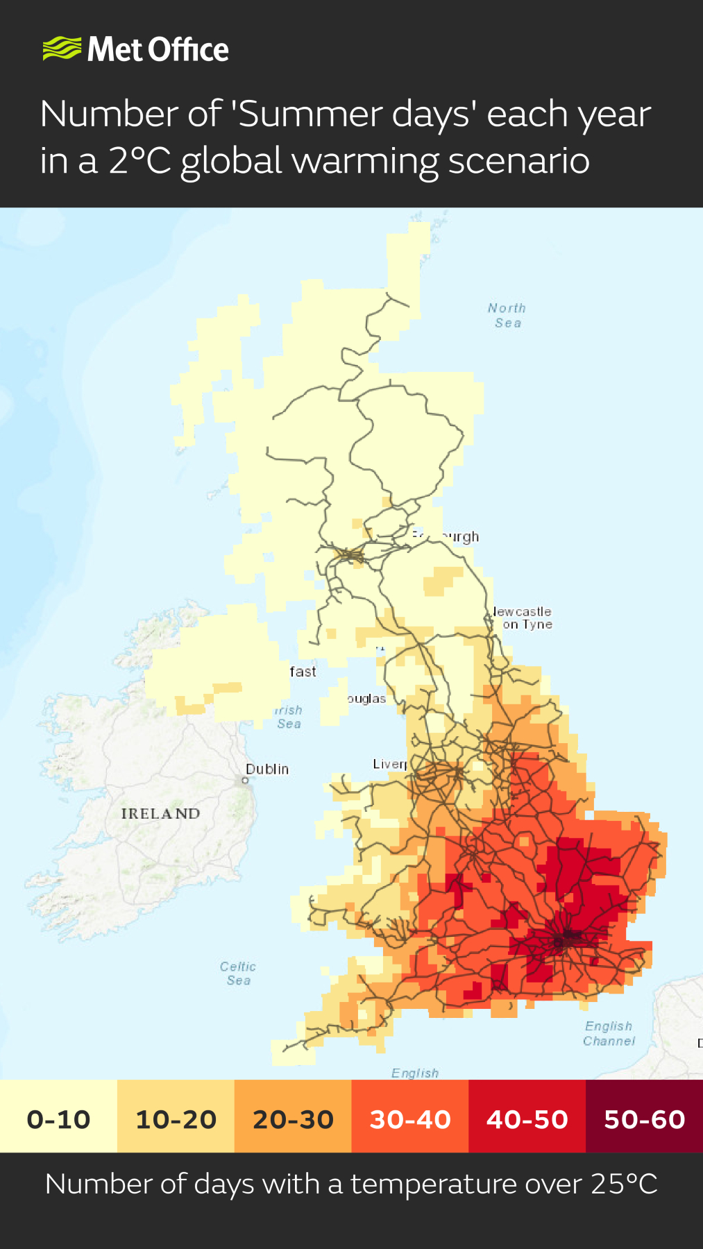
Data on the portal can be used to inform the impacts of climate change. Data on temperature extremes can be used to understand the impacts on transport infrastructure, health and energy demand. For example:
-
Days above 25°C can indicate when trains could be disrupted due to overheating of railway infrastructure
-
Nights above 20°C can indicate heat stress as night time temperatures impact the body’s ability to recover from higher daytime temperatures
-
Days below 0°C can indicate transport disruption and increased energy demand for heating.
Met Office Markets Director, Ian Cameron, said: “The Met Office Climate Data Portal is a vital progression to put our pioneering science data in the hands of the people who need it, in a format that is most useful to them, to enable people to make better decisions to stay safe and thrive. As a globally recognised climate science organisation it’s crucial that we work proactively with partners to provide expert Met Office data and information where they want to access it.
“There are numerous industries that utilise Esri GIS software, so it is significant that they wanted the best environmental data available to make better decisions for their sectors to thrive in a changing climate.”
Emma Teuten, Lead GIS Analyst at RSPB Scotland, said: “The portal makes working with climate data faster and more accurate and saves months of development time when trying to understand the impact of climate change on specific sites in Scotland. We already use Esri’s GIS extensively and the new Met Office portal eliminates the time-consuming data conversion previously required, as the data is now in ready-to-use geospatial formats.”
Harnessing technology
The main users of the new portal are expected to be within government, insurance, transport, energy, land use, urban planning and healthcare industries. Data on temperature extremes, for example, can be used to understand the impact of future heatwaves on transport infrastructure.
“The Climate Data Portal is a giant step forward in making climate data more usable for UK stakeholders,” commented Pete Wilkinson, Managing Director of Esri UK. “Climate change presents a major challenge and this challenge is a geographic one. Using geospatial technology as a delivery mechanism for climate data makes it quickly accessible and usable in spatial and temporal analysis, helping to identify at-risk areas and develop location-specific action plans.”
Stephen Belcher, Chief of Science and Technology at the Met Office, said: “Human induced climate change is having more and more impact on our lives, and it is crucial that new technologies, such as data integration tools, are harnessed to make sure the insights from science are getting into the hands of people who make decisions.”