Red warning for Storm Babet
Author: Press Office
11:52 (UTC+1) on Thu 19 Oct 2023
On Wednesday, the Met Office issued a Red severe weather warning, as Storm Babet is expected to bring exceptional rainfall and impactful wind for some later today and tomorrow.
The Red warning for rain covers parts of the east of Scotland, including Brechin, Forfar and Kirriemuir. It’s in force from 1800 on Thursday through to midday on Friday.
Met Office Chief Meteorologist Jason Kelly said: “Eastern parts of Scotland will see exceptional amounts of rainfall over the next few days and the significant accumulations are likely to cause considerable impacts from Storm Babet.
“Numerous Amber and Yellow rainfall warnings are in place for rainfall over the coming days, up-to and including Saturday, but in the red-warning area 100-150mm of rain is expected to fall quite widely, with some locations possibly seeing 200-220mm, which is expected to cause considerable impacts with flooding likely.”
💧 How much rain will you get?
— Met Office (@metoffice) October 18, 2023
This map shows how much we are expecting from #StormBabet between now and Saturday👇 pic.twitter.com/Sr0OkVLRSX
Impacts highlighted as part of the red warning is a danger to life from flood water, extensive flooding to homes and businesses and severely disrupted travel conditions. This is the first Red warning for rain issued in the UK since Storm Dennis in February 2020.
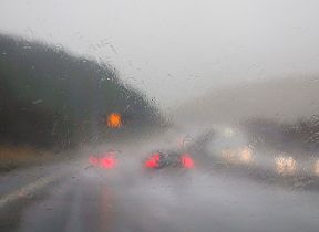
Strong winds from an easterly direction have also resulted in Yellow and Amber wind warnings being issued for eastern parts of Scotland and along the east coast of England until the weekend when winds will eventually ease. Gusts in excess of 70mph are likely on Thursday and 60mph on Friday, with particularly poor conditions on immediate coastlines with large waves adding to the list of hazards.
These warnings will continue to be updated throughout the period, and further warnings are also possible, so it is important to stay up to date with the Met Office forecast and warnings in your area.
Be prepared for potential flooding
Pascal Lardet, Scottish Environment Protection Agency (SEPA) Flood Duty Manager, said: “Scotland has already experienced a significant flood event this month, which communities are still recovering from, and some of the rainfall totals forecast for this week are higher than experienced over that weekend – albeit in some different areas.
“We’re expecting extensive river and surface water flooding in affected areas, with widespread impacts to transport and infrastructure. There is a risk of more significant community scale property flooding – and there will be danger to life.
“Regional Flood Alerts have already been issued, and localised Flood Warnings will be issued over the next few days as rivers respond. However, it is important to note that not all areas that could be affected have Flood Warning schemes, so please do take a Flood Alert in your area as advance notice that you could be affected.
“Take action now to protect yourself and your property. Hazards can be hidden, so please don’t walk or drive into flood water. Remember that not only is flood water likely to be dirty, 30 cm of fast flowing water can move an average family sized car, and just 15 cm of fast flowing water could be enough to knock you off your feet.”
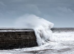
Stay safe near the coast
RNLI Water Safety Partner, Sam Hughes, said: “The forecasted strong winds along with heavy rain are likely to cause dangerous conditions for those visiting the coast around the UK and Ireland.
“The RNLI advises staying a safe distance away from the water and cliff edges as the conditions could knock you off your feet or wash you into the sea. It is not worth risking your life.
“If you see someone else in danger in the water, call 999 or 112 and ask for the Coastguard if by the coast, or the fire service if inland. If you have something that floats that they can hold on to, throw it to them. Don’t go in the water yourself – you may end up in difficulty too.”
The RNLI advice is:
- Stay well back from stormy, wintery seas and cliff edges
- Check the weather forecast and tide times before you go out
- Take a phone with you
- In an emergency call 999 or 112 and ask for the Coastguard
Storm Babet update. Stay safe and keep an eye on the forecast and tides
— HM Coastguard (@HMCoastguard) October 19, 2023
▪️ Watch out for big waves 🌊
▪️ Steer clear of cliffs ⛔
▪️ Put your dog on a lead 🐕🦺
▪️ Stay away from floods 💦
Coastal emergency? Call 999 and ask for the Coastguard #StormBabet https://t.co/blyz7fjInK
Landslides possible
A spokesperson for the British Geological Survey said: “Whilst the landslides will be different to last week’s failures in the West of Scotland with less potential of large-scale debris flows, there is a history of coastal landslides within the warning area. Infrastructure slopes are also likely to be affected with potential for disruption to roads and railway within the warning area.”
Do you know your flood risk?
Could your property be at risk of flooding? Follow this three point plan to check and be prepared: 1. Check if your property is at risk here. If you are at risk take the next two steps to protect your property when you need to, 2. preparing a flood plan, 3. Prepare an emergency flood kit.
Further ahead
Met Office Expert Meteorologist Christoph Almond said: “Sunday looks like a quieter day for many, although there will still be some showers around. However, in lighter winds and with temperatures above average, it could feel comparatively pleasant for a short time. However, on Monday, more heavy rain and showers look like spreading in from the southwest, and that sets the scene for the coming week. While most places will see rain or showers at some point – southern areas could bear the brunt of these.”
You can keep up to date with the latest forecast on our website, by following us on Twitter and Facebook, as well as on our mobile app which is available for iPhone from the App store and for Android from the Google Play store.