Storm Agnes to bring winds and rain
Author: Press Office
10:36 (UTC+1) on Mon 25 Sep 2023
Storm Agnes has been named by the Met Office as the deep area of low-pressure that will impact much of the UK on Wednesday and into Thursday.
Storm Agnes will move into western areas of the UK and Ireland on Wednesday, with the strongest winds most likely on Irish Sea coasts, though it will be a widely windy day across the UK.
Met Office Chief Meteorologist Matthew Lehnert said: “Storm Agnes will approach southwest Ireland early on Wednesday and track northeast across Northern Ireland and Scotland before clearing on Thursday morning. Gusts of 45-55 mph are expected widely inland and 50-60 mph over hills and around coasts.
“The strongest winds are expected to affect Northern Ireland, southwest Scotland, west and northwest Wales, Cumbria and Lancashire where some places inland may see gusts of 50 - 60 mph and 65-75 mph over hills and around coasts. These are most likely during the second half of Wednesday afternoon and through the evening."
⚠️ Yellow weather warning UPDATED ⚠️ #StormAgnes is expected to bring strong winds across a large part of the UK
— Met Office (@metoffice) September 27, 2023
Today 1200 – Thursday 0700
Latest info 👉 https://t.co/QwDLMfRBfs
Stay #WeatherAware⚠️ pic.twitter.com/yQ59zaWm47
A Yellow Warning for wind has been issued for a large area of the UK, with rain warnings also issued for parts of Scotland and Northern Ireland.
The wind warning highlights the chance of some damage to building from strong winds, as well as the possibility of power cuts for some. Transport disruption is also likely, with some roads and bridges likely to close.
⚠️ #StormAgnes will bring strong winds and heavy rain to much of the UK this afternoon
— Met Office (@metoffice) September 27, 2023
⛅ Remaining drier across the southeast with some sunny spells and lighter winds pic.twitter.com/V5iYn9CNOc
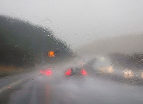
Steve Basterfield, National Network Manager at National Highways, said: “With the stormy weather being forecast, it is important to plan ahead for your journey, and if weather conditions become challenging, adjust your driving behaviour and take extra care.
“We have a section of our website dedicated to travelling amid storms, high winds and gales, and considerations for different types of vehicle, as part of our guide to travelling in severe weather. It’s also a good idea for people to check their vehicles, such as tyres, coolant and oil levels, before heading out to reduce the risk of breakdowns.”
Stein Connelly from Transport Scotland said: “Storm Agnes is the first storm of the year and it’s expected to bring some disruption to the transport network, so we’d ask people who are looking to travel to plan their journeys ahead of time.
“Traffic Scotland will have regular updates on the trunk road network on it’s webpage - my.trafficscotland.org – and via its twitter/X account, including details of ‘wind based’ closures for the major bridges around the country.
“The conditions could also lead to disruption on other modes of transport, so if you’re planning to travel by train, ferry or air, you should check with your operator to see if your service is affected.”
Storm Agnes is the first named storm of the storm naming season, which runs from September to August the following year.
Rain impacts in Scotland
David Morgan, Flood Duty Manager for the Scottish Environment Protection Agency (SEPA), said: “Storm Agnes, the first named storm of the year, will move across Scotland tomorrow, bringing strong winds and heavy rain in many parts of the country.
“Flooding impacts are possible, particularly in south west and central areas. Along the south west coast, we may see wave overtopping and flooding of causeways, promenades, properties and roads. Impacts are expected to be localised and around high tide. We may also see minor flooding impacts from surface water and rivers.
“Flood Alerts and Warnings are being issued as necessary and we continue to work with the Met Office to monitor the situation 24/7.
“People living and working in affected areas are advised to take care if travelling and consider any steps they need to take now to be prepared and to stay safe.
“We are also encouraging people to sign up to Floodline to receive free updates for where they live, or travel through, directly to their phone. People can also check our Flood Updates for all the latest information and the three-day Scottish Flood Forecast to see what conditions are expected further ahead.”
Further ahead
Storm Agnes’s influence on UK weather is expected to diminish later on Thursday as it weakens and moves further north. Another system will then move into southern areas late on Thursday and into Friday bringing some heavy bursts of rain for some areas of England and Wales.
It will become drier for Friday, and stay mostly dry until Saturday night. We will see some brighter spells and heavy showers on Sunday.
You can check the latest forecast on our website, by following us on Twitter and Facebook, as well as on our mobile app which is available for iPhone from the App store and for Android from the Google Play store.
Updated at 11:12 (UTC+1) on Wed 27 Sep 2023