Wind warnings issued
Author: Press Office
10:18 (UTC+1) on Wed 12 Apr 2023
A large Atlantic low pressure system, named Storm Noa by the French meteorological service, is bringing strong winds, low temperatures and heavy rain or showers to many places.
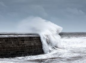
Yellow wind National Severe Weather Warnings have been issued highlighting the potential for impacts such as travel disruption and the possibility of large waves in coastal areas in south Wales and southern England. There could be some snow over higher ground in the north at times.
Météo-France has named this low pressure system Storm Noa as it will bring strong winds across northern France.
Met Office Chief Meteorologist, Matthew Lehnert, said: “Most places will see showers or longer spells of rain today but the impacts are most likely to come from strong winds. Gusts of 50-60 mph are possible quite widely in the southwest, with up to 75 mph in exposed coastal areas.”
“Some disruption due to strong winds is expected in southern areas, particularly the south coast of Wales and southwest England. It will be a cool day with temperatures of 7 to 10 C in the west, with 11 to 13 C possible in the southeast, however it will feel colder in the strong winds.”
🌦️ A chilly start to Wednesday with sunshine and showers, these heavy and thundery at times
— Met Office (@metoffice) April 11, 2023
🌨️ Showers wintry in places, mainly over any high ground
🌬️ Strong winds with severe coastal gales in the south and west
⚠️ Stay #WeatherAware pic.twitter.com/lT4tqcV0RT
It will stay unsettled through the rest of the week, with sunshine and heavy showers for many tomorrow with persistent rain in the south on Friday, before it becomes drier and brighter as we head through the weekend and more especially next week with temperatures starting to rise.
You can check the latest forecast on our website, by following us on Twitter and Facebook, as well as on our mobile app which is available for iPhone from the App store and for Android from the Google Play store. Keep track of current weather warnings on the weather warning page.