Unsettled week ahead
Author: Press Office
12:40 (UTC+1) on Tue 11 Apr 2023
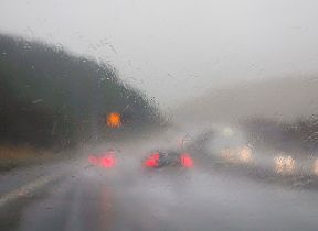
An Atlantic low-pressure system moving slowly eastwards across the UK, is bringing strong winds, low temperatures and heavy rain or showers to many places.
We have an unsettled few days to come, yellow wind and rain warnings have been issued and in the north there could be some snow over higher ground at times.
The warnings highlight potential travel disruption and the possibility of large waves in coastal areas in the south and west.
🌧️ Rain and strong winds will arrive from the southwest through this afternoon
— Met Office (@metoffice) April 11, 2023
🌦️ Sunny spells further north and east, although scattered showers at times
🌡️ Feeling pleasant in the sunshine, but cooler in the west
⚠️Stay #WeatherAware pic.twitter.com/yHMQcw1czi
Met Office Chief Meteorologist, Matthew Lehnert, said: “A low pressure system will bring a period of wet and windy weather today and tomorrow. Thick cloud and heavy rain will continue to push in from west bringing 50 to 60 mph winds along western coasts. Snow is likely to fall over parts of upland Scotland overnight.
“Some disruption due to strong winds is likely on Wednesday, especially in southern and western areas, as well as the potential for heavy rainfall and even some snow, though the latter probably confined to high ground in the north. It will be another cool day with temperatures of 7 to 10 C in the west, with 11 to 13 C possible in the southeast, however it will feel colder in the strong winds.”
It will stay unsettled through the rest of the week, with sunshine and heavy showers for many on Thursday, and persistent rain in the south on Friday, before it becomes drier and brighter as we head through the weekend and more especially next week with temperatures starting to rise.
You can check the latest forecast on our website, by following us on Twitter and Facebook, as well as on our mobile app which is available for iPhone from the App store and for Android from the Google Play store. Keep track of current weather warnings on the weather warning page.