Warnings issued for windy weather to come
Author: Press Office
12:09 (UTC+1) on Sun 9 Apr 2023
After a largely fine and dry Easter weekend for most, things are turning more unsettled, with wind warnings in force from Tuesday afternoon.
High pressure, which has been responsible for the dry and fine weekend weather for most, has moved away to the east, to be replaced by a westerly Atlantic regime, with periods of winds and rain to come.
Warnings issued for next week
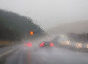
The wet and windy weather will continue this week, with fronts arriving from the southwest bringing further periods of rain for many from Tuesday.
A developing low-pressure system looks likely to bring a more sustained period of wet and windy weather from Tuesday and into Wednesday, which has resulted in the issue of yellow wind warnings.
The warnings highlight potential travel disruption and the possibility of large waves in coastal areas in the south and west.
⚠️ Yellow weather warning updated ⚠️
— Met Office (@metoffice) April 10, 2023
Wind across western parts of the UK
Tuesday 1500 – Wednesday 0300
Latest info 👉 https://t.co/QwDLMfRBfs
Stay #WeatherAware⚠️ pic.twitter.com/AKgzotkSyM
Met Office Deputy Chief Meteorologist Steven Keates said: “The focus for the medium-range forecast is a low-pressure system that’s likely to develop just to the southwest of the UK, potentially bringing a period of high winds and heavy rain late on Tuesday and into Wednesday.
“There’s a distinct possibility of some disruptive wind for parts of the UK, especially in southern and western areas, as well as potential for heavy rainfall and even some snow, though the latter probably confined to high ground in the north.
“Although subject to a large degree of uncertainty, gusts of wind could be in excess of 60 mph in some exposed upland or coastal regions, with around 35-50 mm of rain possible for some areas.”
That low pressure is likely to gradually move into the North Sea late through Thursday, though there are signals for some further rain to come later next week.
You can check the latest forecast on our website, by following us on Twitter and Facebook, as well as on our mobile app which is available for iPhone from the App store and for Android from the Google Play store. Keep track of current weather warnings on the weather warning page.
Updated at 14:04 (UTC+1) on Mon 10 Apr 2023