Weather for the Coronation
Author: Press Office
13:25 (UTC+1) on Tue 2 May 2023
The weather forecast for the Coronation of Their Majesties King Charles III and Queen Camilla.
As we get closer to the date of the Coronation on Saturday 6 May, the forecast detail is becoming clearer. Through the first part of this week much of the UK will remain dry with cloud covering most areas. The best of any sunshine through Tuesday will be in the southwest of England and far north of Scotland. Temperatures could reach 19°C in the southwest.
Through Wednesday there will be less low cloud around and hazy sunshine across much of the UK, though some showery rain will move into the west of Scotland, brightening up later on. Highs of 18°C are possible in the southwest though it may not feel as warm, as a strengthening wind begins to develop through the day.
Thursday will be a more unsettled day, with an area of low pressure bringing some wet and windy weather which will move north eastwards across the UK. Most areas will be cloudy through the day, with temperatures capped at 16°C.
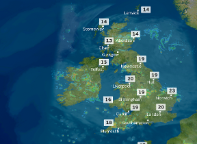
Friday will be a day of sunshine and showers, which could be heavy and slow moving at times. The showers will affect all parts of the UK, including London, with some more persistent rain along the northeast coast of England. Highs of 19°C are once again possible in the south of England.
Weather by the weekend
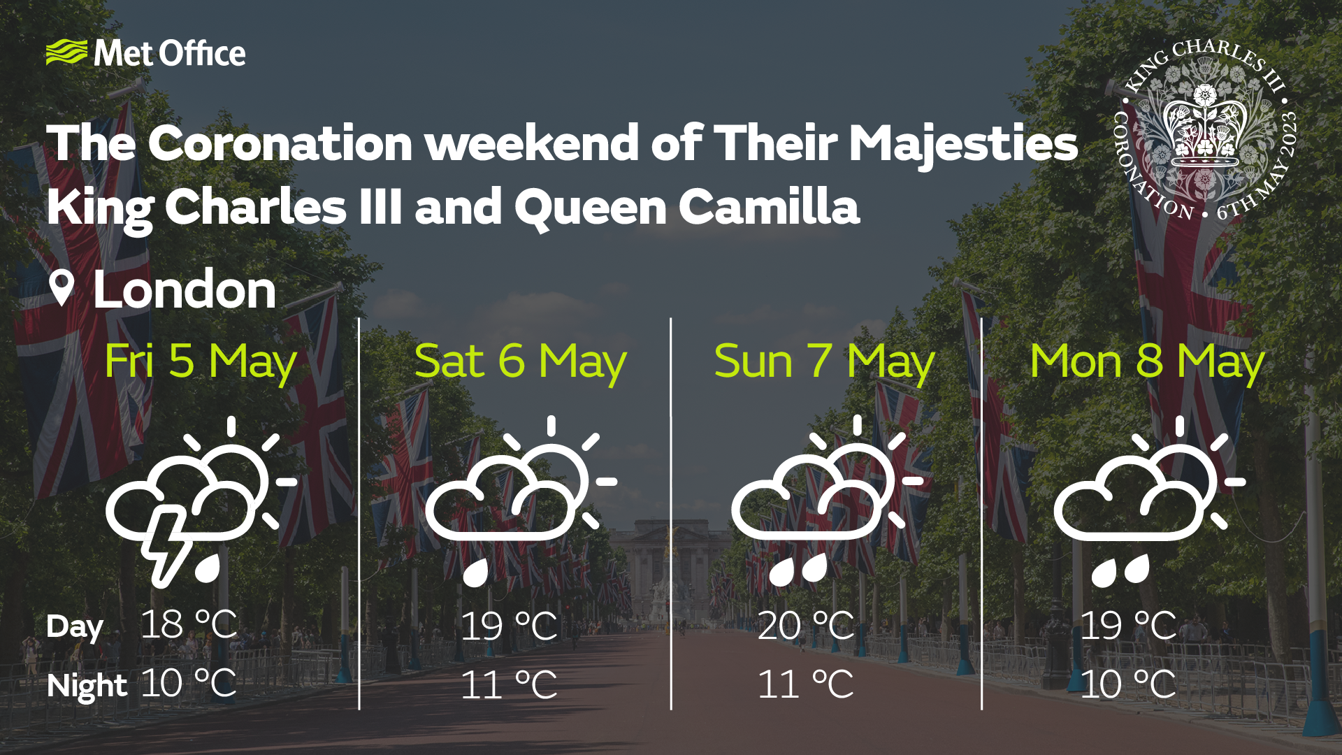
Currently Saturday is forecast to be another showery day, though with less widespread and intense showers compared to Friday.
Met Office Deputy Chief Forecaster, Steven Keates, explains: “On Saturday we will see showers developing from late morning in some central, eastern and northern areas, but also with some sunny spells through the day. At this stage it looks like London could avoid the showers in the morning before some develop through the afternoon. Heavier rain is expected to move into the southwest of the UK and heavy showers are likely for parts of Northern Ireland. Winds will remain light away from the far north where gusty winds will begin to ease. Highs of 20°C are possible in London in any sunshine, with mid to high teens possible elsewhere.”
Will the weather affect your plans during the #CoronationWeekend?
— Met Office (@metoffice) May 2, 2023
🌧️ Showers, thunderstorms and longer spells of rain may affect many areas of the country at times, so keep checking back for updates to the forecast as we move through this week. Here's the latest 👇 pic.twitter.com/ikQRTrsuub
Further ahead
With celebrations continuing through the Bank Holiday, Sunday will see areas of rain breaking up into heavy, possibly thundery showers for many parts of England and Wales. The driest and brightest weather looks set for parts of Northern Ireland and northern Scotland.
Monday is more uncertain at this stage, with the current outlook looking to remain unsettled before higher pressure starts to become more dominant by the middle of the week bringing a more settled spell.
If you want more in depth information about the forecast over the coronation weekend, watch our latest ‘Deep dive’ presented forecast.
Weather over past Coronations
Data from the Met Office archive shows that past coronations back to Edward VII have been mixed when it comes to the weather. The Coronation of HM Queen Elizabeth II saw temperature highs of just 11.8°C on 2 June 1953 with some light rain through the day. The Coronation of HM King George V was the mildest of the last four monarch’s Coronation, with daytime highs of 17°C on 22 June 1911.
| Coronation | Date | Daily max temp (°C) | Daily min temp (°C) | Daily rain (mm) | Daily sunshine (hours) |
|---|---|---|---|---|---|
| Edward VII | 09/08/1902 | 16 | 9.1 | 0.5 | - |
| George V | 22/06/1911 | 17 | 12.8 | 0.3 | 0 |
| George VI | 12/05/1937 | 14.2 | 6.2 | 8.2 | 0 |
| Elizabeth II | 02/06/1953 | 11.8 | 6.8 | 2.6 | 1.2 |
We will continue to update the forecast here on our website and on our mobile app, which is available for iPhone from the App store and for Android from the Google Play store. Keep up with the latest on our social media accounts on Twitter and Facebook. Any weather warnings will be posted on the weather warning page.