
Supporting the military since World War I
Weather forecasting has become a key part of British military strategy since the Met Office started supporting the UK Armed Forces during the First World War.
The Meteorological Field Service
By 1915, the Meteorological Field Service, known as Meteor, was operating from the British Expeditionary Force General Headquarters in Montreuil, France. Meteor was run by Major H.G. Lyons of the Royal Engineers. Two Meteorological Office staff, Ernest Gold and AEM Geddes, were granted temporary appointments in the General List as Captain and Lieutenant respectively. The service was supported by the Meteorological Office in London, which became operational 24/7 for the first time.
The Battle of Passchendaele (also known as the Third Battle of Ypres) took place in a low lying area on the Western Front from 31 July to 10 November 1917. The end of July to the end of August was one of the wettest periods of weather for 75 years. August was an exceptionally wet month; in Ypres 127mm of rain, around 60mm more than average, fell during the 31 days.
The adverse weather conditions hampered military operations during the battle. The water table was very high, just 35cm below the surface, and parts of the battlefield were swamp or reclaimed swamp, interlaced by a series of crucial drainage ditches which were destroyed by shelling. Any trench or shell hole immediately filled with water due to the high water table. Subsequently forecasts became critical in the planning of military operations.
When the weather finally improved in late September there were several attacks. The Battle of Menin Road Ridge, from 20 to 25 September, was swiftly followed by the Battle of Polygon Wood from 26 September to 3 October. Then the Battle of Broodseinde was fought on 4 October, and it led to British possession of the ridge east of Ypres.
Meteor, forecast the improved conditions and also, perhaps more crucially, the end of good weather and onset of poor conditions in early October. Ernest Gold’s diary includes notes from meetings and telephone calls with General Plumer, commander of the 2 Army and his Chief of Staff General Harrington, warning them of deteriorating weather.
Synoptic charts for the Battle of Langemarck and the North West Europe charts for the Battle of Menin Road Ridge were specifically designed to cover the Western Front. They also included information from pilot balloons, small meteorological balloons used to track air currents.
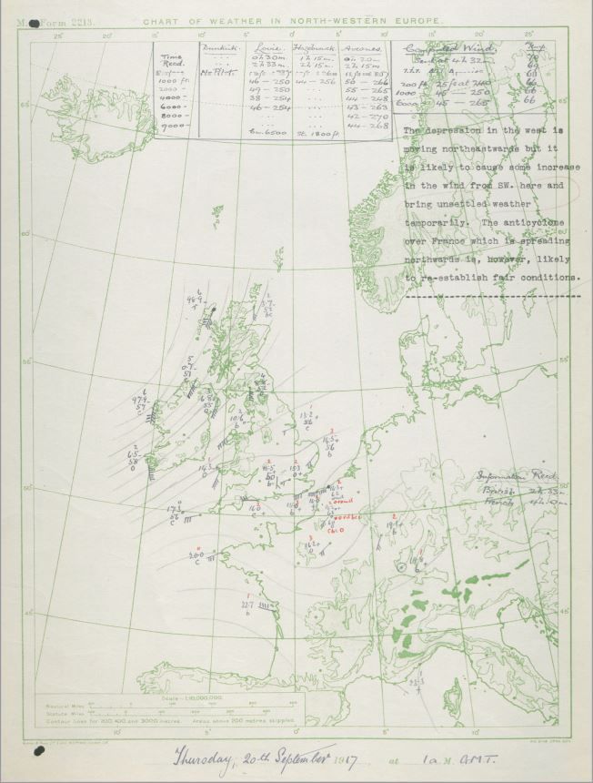 Synoptic chart for 20 September 1917 when the Battle of the Menin Road Ridge began
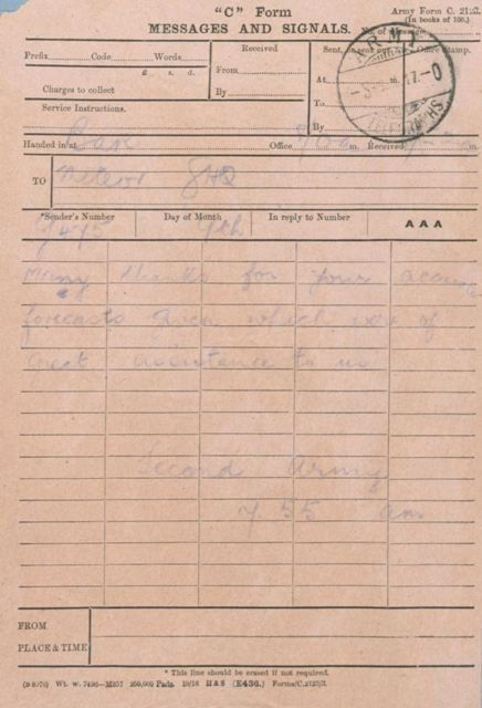
This telegram of thanks, from a senior allied commander to Meteor, reflects an ever increasing trust in, and reliance on, accurate weather forecasting.
Modern defence forecasting
By the end of World War I, weather forecasting had become key part of British military strategy. The Met Office again played a pivotal role in World War II, advising on and providing key forecasts in the run-up to D-Day.
Today the Met Office continues to support British Armed Forces in the UK around the globe, with staff serving in the Mobile Met Unit. This enables the protection, security, independence and interests of the UK and its key allies at home and overseas.
The video below, made by Simon Newton in Cyprus for British Forces Broadcasting Service, shows how our forecasts are used today.
The video below discusses the challenges of forecasting the weather in Helmand Province of Afghanistan.