
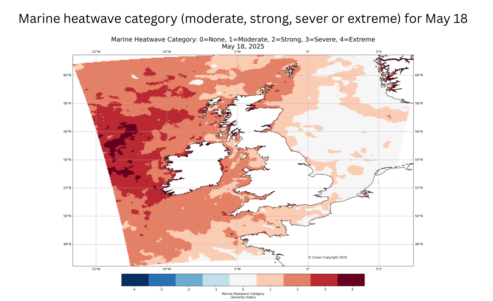
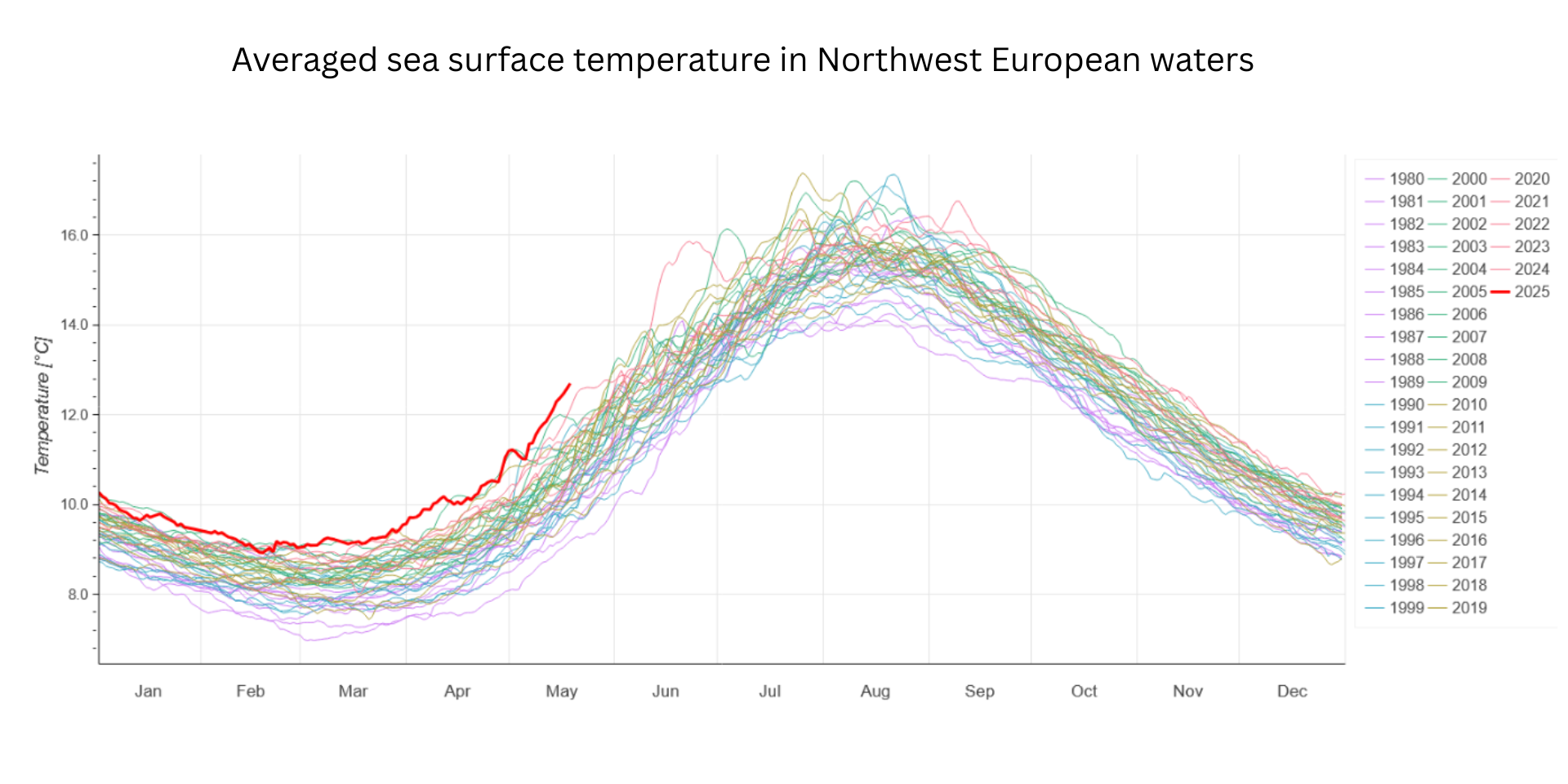
Northwest European waters are currently experiencing an extreme marine heatwave, with sea surface temperatures (SSTs) reaching record highs for April and May since satellite monitoring began in 1982.
This event, now lasting over two months, is significant due to its intensity and persistence. Current sea surface temperatures are warmer by up to 4°C west of Ireland, and by 1.5-2.5°C around the UK coastline: temperatures are what we would usually expect around mid-June.
The heatwave is the result of several overlapping factors. Prolonged high-pressure systems brought a dry, sunny spring and weak winds and waves, creating ideal conditions for warming. This means the sea started to warm mid-February, one month earlier than usual. Additionally, the waters around the UK were already warmer than usual coming out of winter, a trend that has been building over the past 40 years, with an average increase of 0.3°C per decade.
READ MORE: Why has spring been so warm and dry so far this year?
A key feature of marine heatwaves is the formation of a warm layer at the ocean’s surface. This layer acts like a lid, trapping heat near the surface and preventing it from mixing into deeper, cooler waters. It can be compared to a layer of olive oil floating on water, this thin surface layer allows heat from solar radiation to accumulate near the surface. When this layer forms, surface temperatures can increase fast: the last 9 days have seen a sudden additional 1°C warming.
Marine heatwaves in UK waters usually last around two to four weeks. This year’s event began early March and has continued into May, making it one of the longest on record for this time of year. The North Sea has already peaked in temperature, while areas west of Ireland and the Celtic Sea are currently experiencing their highest levels.
This prolonged warming can amplify land heatwaves by reducing the cooling effect of sea breezes and by altering rainfall patterns. Dr Jonathan Tinker, marine climate scientist, said: "With projections suggesting UK summer sea temperatures could rise by up to 2.5°C by 2050, such events are likely to become more frequent, intense and longer-lasting. Marine heatwaves offer a glimpse into how changing ocean conditions could shape future weather conditions."
READ MORE: Met Office Weather Deep Dive: A change is on the way
Cooler weather and stronger winds expected over the weekend are likely to ease the marine heatwave. With temperatures dropping and westerly winds picking up, the stable “olive oil” surface layer may begin to break down, allowing cooler water to mix in and gradually reduce sea surface temperatures.
Centre for Environment, Fisheries and Aquaculture Science (CEFAS), Plymouth Marine Laboratory (PML) and The National Oceanography Centre (NOC) are keeping a close eye on what this means for our ecosystems and fisheries. Met Office is bringing together the UK and Irish research community with Defra at Reading University on 22nd May to discuss science and research ongoing in UK marine heatwaves.
Keep up to date with weather warnings, and you can find the latest forecast on our website, on YouTube, by following us on X and Facebook, as well as on our mobile app which is available for iPhone from the App store and for Android from the Google Play store.