
Positive impacts of ensemble forecasts
The ensemble forecasts produced by the Met Office have had a beneficial impact on many different users.
The ensemble forecasts produced by the Met Office have had a beneficial impact on many different users, either through helping our forecasters pinpoint the greatest risks when issuing warnings, or more directly through businesses using the ensemble guidance in their decision-making processes.
Case study 1
One high profile case was the heavy rainfall event on 25 June 2007, which resulted in widespread flooding in northern England. This high rainfall was highlighted by the ensemble well in advance, shown in Figure 1, giving forecasters the confidence to issue severe weather warnings well ahead of the event.
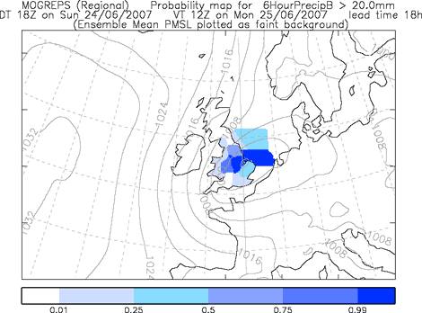
Figure 1: A probability chart produced 18 hours ahead, showing a high probability of the six-hour rainfall exceeding 20 mm in northern England
Case study 2
Another example of a high-impact forecast, where forecasters were helped by the use of ensembles, was for new year celebrations in Scotland in 2006/7.
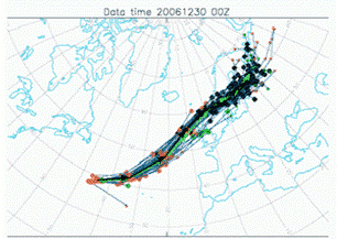
Figure 2: Forecast storm tracks from a developing storm, using ensemble members from the ECMWF.
On 30 December 2006 the model indicated a risk of a strong wind-storm event which could pose a serious danger to the public celebrating new year outdoors. Figure 2 shows the tracks of the developing storm in different members of the ECMWF ensemble forecast. This indicated a very high confidence that the storm would track over northern Britain during the evening of 31 December.
Further analysis also showed a high probability of very strong winds associated with this storm. This gave forecasters the confidence to advise organisers on the cancellation of high-profile street parties in several cities, helping to ensure that people celebrated a safe as well as a happy new year.
Case study 3
A third example was the storm surge event on 9 November 2007. The output from the Met Office ensemble system (MOGREPS) was showing a high probability of high wind speeds down the east coast of Britain, giving ideal conditions for the development of a storm surge (see Figure 3).
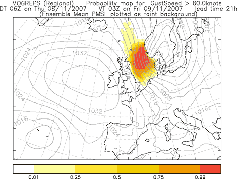
Figure 3: A probability chart produced 21 hours ahead, showing a high probability of the wind gusts exceeding 60 knots down the east coast of Britain.
To fully assess the risk of coastal flooding, output from MOGREPS was coupled to a storm surge model through a collaborative experimental project funded by the Environment Agency. The project helped forecasters assess that there was a high risk of coastal flooding, giving local authorities timely warnings about the need to protect the public. This example demonstrates how our ensemble output can be used to drive an application for a specific customer.