Met Office Deep Dive: UK weather forecast and what's in store for winter?
As meteorological winter begins, many are wondering what the coming months will bring, will it be mild, wet, cold, or snowy?
This week’s Deep Dive delves into the forecast, the science behind it, and what it means for the UK.
A saturated start and unsettled pattern
The week began with notably wet conditions across much of the UK, leaving the ground well saturated. This sets the stage for the rest of the week, with further rainfall expected and a series of low-pressure systems influencing the weather. The persistent unsettled pattern is being driven by a strong jet stream, which is in full force and steering weather systems across the country.
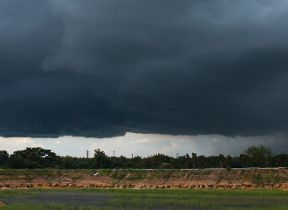
Rainfall outlook: persistent and locally heavy
Looking ahead through the week, the forecast indicates a continuation of showery and wet conditions, particularly in western areas. A narrow but potent front is expected to move through on Wednesday night into Thursday, potentially bringing around 20 mm of rain in just six hours as it sweeps across the country. While this amount of rainfall is not typically enough to cause major issues, the already saturated ground, especially in South Wales and parts of northwestern England, means that even moderate rainfall could lead to short-lived flooding issues.
Despite the recent heavy rain, this is not enough to make up for the rainfall deficit from the spring and summer, so water restrictions remain in place. Keep an eye on the forecast and for any warnings that may be issued through the week.
Model differences and forecast uncertainty
One of the challenges in forecasting this week’s weather is the subtle differences between model outputs. The Met Office global model and the European ECMWF model have shown some variation in the position and movement of low-pressure systems, particularly for Friday and into the weekend. These differences can affect the timing and intensity of rainfall, as well as the risk of fog and even some snow over high ground in northern England, Scotland, and North Wales.
Fog is a particular concern for Friday morning, especially across central and eastern England, as a lull before the next band of rain allows conditions to become conducive for its formation. The arrival of rain and increasing winds will eventually clear the fog, but the exact timing remains uncertain.
Temperature trends: mild with brief cold dips
The temperature outlook for the next ten days is generally unremarkable. While there is a brief cold dip expected on Friday morning, the overall trend is for temperatures to remain around average or slightly above. This means high single figures for much of the country, with no widespread, long-lived frosty cold snaps or significant spells of high pressure in the forecast. Northern areas may see slightly more members of the forecast ensemble indicating colder conditions, but the main trend remains mild.
Winter outlook: average conditions most likely
Turning to the broader winter outlook, the Met Office’s three-month forecast covers December, January, and February. The key message is that there is no particularly enhanced signal for extreme conditions this winter. The most likely outcome is for near-average conditions, with a slightly increased chance of milder weather patterns but only a small reduction in the likelihood of cold spells.
Extreme events, such as prolonged heavy rainfall or significant cold snaps, cannot be ruled out, but the risk is no higher than it would be in a typical winter. The forecast is based on a combination of model outputs and climatology, with the “near average” category representing the most probable scenario. This means the UK could experience a bit of everything, from mild and wet to cold and frosty, but no single pattern is expected to dominate.
For those hoping for a white Christmas or a prolonged cold snap, the current outlook suggests these are less likely, but as always with UK weather, nothing can be ruled out entirely.
The role of the jet stream
The jet stream is a fast-flowing ribbon of air high in the atmosphere, and it plays a crucial role in shaping the UK’s weather, especially during winter. At this time of year, the temperature contrast between the cold Arctic and the milder air from the south is at its greatest, enhancing the strength of the jet stream. This contrast is particularly pronounced at the moment, with cold air diving down from the Arctic over Canada and mild air pushing up from the equator.
This dynamic is not only driving unsettled weather in the UK but is also contributing to the development of a nor’easter in the northeastern United States. As this potent area of low pressure moves into the Atlantic, it will continue to influence the UK’s weather, bringing further spells of rain and wind.
High pressure and blocked systems
While the jet stream is bringing in low-pressure systems from the Atlantic, high pressure is building over eastern Europe and Russia. This is typical for the time of year but is currently stronger than usual. The presence of this high pressure acts as a block, preventing low-pressure systems from progressing further east. As a result, the UK is experiencing persistent areas of low pressure, leading to repeated bouts of rain and little change in the overall weather pattern.
The influence of global drivers
Global climate drivers, such as El Niño and La Niña, play a role in shaping seasonal forecasts. This winter, a weak La Niña event is present in the Pacific Ocean. La Niña typically shifts the areas of showers and thunderstorms in the tropics, which can have ripple effects on mid-latitude weather patterns, including those in the UK. In particular, La Niña tends to increase the likelihood of westerly winds in the second half of winter, bringing milder, wetter, and stormier conditions from the Atlantic.
However, it is important to note that La Niña is just one factor among many, and its influence can be offset or enhanced by other elements in the climate system. The current La Niña is relatively weak, and while it may contribute to the overall pattern, it does not guarantee a specific outcome for the UK.
Sudden stratospheric warming and the polar vortex
Another phenomenon that can influence UK winter weather is sudden stratospheric warming (SSW), which can disrupt the polar vortex and increase the chance of colder, easterly winds. Recently, a minor SSW event occurred, causing a temporary weakening and displacement of the polar vortex. However, forecasts suggest that the vortex will quickly regain strength, reducing the likelihood of significant cold spells in the immediate future.
Major SSW events, which can lead to prolonged cold weather in the UK, are not currently indicated by the models. The risk of such events remains close to normal for the time of year, and all options remain open as winter progresses.