Met Office daily weather: Largely dry start to the week
The latest Met Office weather forecast suggests it will be a largely dry start to the week for many
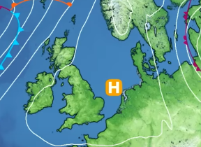
A largely dry start to the day across much of the UK, with just a few showers affecting northern Scotland and parts of western coastal areas.
Elsewhere, it will be a fine morning with bright or sunny spells developing widely. Through the afternoon, scattered showers are expected to develop, particularly across England and Wales, though many areas will remain dry. Cloud will begin to thicken from the west later in the day, ahead of an approaching weather front. Temperatures will be near average for the time of year, with highs reaching the low 20s across the southeast, and high teens more typical further northwest.
Cloud and outbreaks of rain will begin to move erratically eastwards into Northern Ireland, western England, Wales, and parts of western Scotland overnight. Some heavier bursts are likely, with the possibility of the odd rumble of thunder. Conditions will become increasingly warm and humid in the west, with extensive low cloud developing. Temperatures will remain around average overnight.
Red more on Apple News: What are weather fronts?
Outlook for Tuesday
A band of cloud and rain will continue to move south-eastwards through the day, with some locally heavy rain possible across parts of Wales, western and southwestern England. This rain will tend to fragment into showers during the afternoon. Elsewhere, conditions will be drier, with the best of the sunshine expected across central, northern, and eastern Scotland. Where cloud persists, particularly in a corridor from the Peak District to central southern England, temperatures will be more subdued. However, where skies brighten either side of this zone, highs of 24-25°C are possible. Elsewhere, temperatures will generally range from the high teens to low 20s.
Rather cloudy conditions will persist for many, with some patchy rain or residual showers in places. However, most areas will remain dry overnight. A few clear spells are likely, and some low cloud or isolated fog patches may develop by dawn. Overnight temperatures will be largely unremarkable and close to average for late July.
Read more on Apple News: Understanding covergence zones and the Intertropical Convergence Zone
Met Office presenter and meteorologist, Ellie Glaisyer, said: “It's a bit of a drier and brighter start for many of us out there this morning, particularly compared to what we saw on Sunday. Plenty of sunshine to start the day across the country. We will see some isolated showers just feeding in from the northwest. One or two bubbling up across parts of England and Wales through the afternoon, but these will be fairly light and fairly well scattered. And there should be a bit more in the way of sunshine between those showers, particularly compared to what we saw on Sunday.
“The sun's still strong at this time of year. This is where we do see that sunshine, it will be feeling pleasantly warm. Highs in the south of 24°C, perhaps 25°C and even across Scotland and Northern Ireland, we could see temperatures reaching into the low 20s, too. So, feeling pleasantly warm if you are spending the day out and about on your summer holidays.
“As we then go through the rest of Monday evening, any late sunshine we see across Northern Ireland perhaps turning a little hazy in places as we see this weather front arriving. Elsewhere, any showers that we've seen through the day gradually starting to ease. So, turning dry for much of the country initially before we see this area of rain pushing its way eastwards. Turning perhaps a little heavy across parts of western Scotland, northern parts of England. Quite a lot of cloud associated with this too, but staying a little drier with some clear spells across the southeast.
Read more on Apple News: What are the top 10 highest temperatures recorded in July?
“However, in the towns and cities, generally still staying quite mild overnight, holding up well into the double figures, although where we do see those clear spells, perhaps turning a little fresher in some rural spots, maybe dropping down into the high single figures.
But that does mean quite a cloudy and damp start, particularly across the northwest on Tuesday morning, particularly compared to today as well. That air of rain continues to slip its way south and eastwards as we go through the morning and generally turns a little more showery as we go into the afternoon, but we could still see some heavier downpours. Maybe a bit of sunshine developing across the very far northeast, but generally quite a bit more cloud around on Tuesday compared to what we're seeing through today.
“Temperatures will be pretty similar today though, 23°C or 24°C in the south, but with plenty more cloud and a bit more moisture around, that could mean it feels quite a bit more humid, quite a bit more muggy than what we saw on Monday and particularly over the weekend as well. There are further showers and some longer spells of rain on the cards as we go through much of this week.”