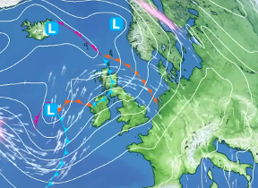
Met Office daily weather: Mixed conditions follow on from Storm Floris
As we move further into August, a mix of conditions are expected across the country.
As we move further into August, a mix of conditions are expected across the country.
Wednesday will bring a more settled start for much of the UK, with dry conditions and sunny spells expected across central and southern areas. Northern parts, particularly the Northern Isles, will remain cloudier with patchy rain or drizzle at times. Through the afternoon and evening, cloud will begin to increase from the west, ahead of an approaching weather front.
Winds will generally be light to moderate, helping most areas feel warmer than Tuesday. However, winds will begin to strengthen in the northwest later in the day. Temperatures will be close to average for the time of year, with many locations feeling more pleasant in the lighter winds. The exception will be along the south coast, where a sea breeze may keep temperatures a few degrees lower than Tuesday.
During Wednesday evening, rain will begin to spread into northwestern parts of the UK, moving south-eastwards overnight. Some heavy bursts are possible on the leading edge of this rain band, particularly across parts of northern and northwestern Scotland later in the night. Southern and southeastern areas will remain dry, with variable cloud cover.
Storm Floris has now cleared the UK, and is tracking across Norway today
— Met Office (@metoffice) August 5, 2025
Here’s a 24 hour satellite view showing Floris crossing the UK on Monday 🛰️ pic.twitter.com/4NT5fqemuZ
Winds will become increasingly strong in the northwest, with gusty conditions developing overnight. Temperatures will be milder than the previous night, remaining near average across most areas.
Outlook for Thursday
Thursday will see a band of rain continuing to move south-eastwards across the UK. While some heavy bursts are possible in the west and north, the rain will tend to fragment as it reaches central and southern England. Northern areas will remain windy, with a risk of coastal gales, particularly in exposed locations.
Temperatures will be mostly near average, though it will feel rather cool in the northwest under cloud and rain. Southern areas may see brighter spells later in the day, helping conditions feel more pleasant despite the earlier rain.
Met Office presenter and meteorologist, Aidan McGivern, said: “Storm Floris is now moving away, having brought widespread disruption across northern parts of the UK. One of the strongest August storms on record with the joint highest August wind gust for Northern Ireland on record, Orlock Head, 66 mph. And for Scotland, 82 mph in Wick.
Read more on Apple News: What's the weather looking like for this week's festivals?
“Now, it's still going to be blustery as Storm Floris pushes into Norway and Sweden, but actually it's much less windy compared with Monday. Frequent showers initially across northwestern areas, transferring into northeastern areas as the day goes on. Hail and thunder in places, but those showers peeking around lunchtime before becoming fewer and further between later in the afternoon. Mostly dry towards the south with sunny spells, lighter winds, and feeling pleasant enough. Cool in the brisk breeze further north. 35–40 mph wind gusts across northeastern parts of the UK. But those winds tend to fade as the night approaches and there will be some cloud and patchy rain into the north of Scotland.
“Further south, plenty of clear spells, lighter winds, a few mist patches towards the southwest as well as Northern Ireland and a cooler night compared with previous nights. Temperatures in some shelter spots dipping into the single figures. Plenty of sunshine though as we begin Wednesday. Light winds feeling very pleasant indeed across the vast majority of the UK. The one exception once again the far north of Scotland where we will see thicker cloud and a spell of light patchy rain moving northwards and disappearing to the far north into Wednesday afternoon.
“Thicker cloud comes along into the west by the afternoon, but it stays dry and bright in most places, feeling pleasant in the light winds and sunny spells uh into the afternoon. Now, the thicker cloud in the west will bring about some patchy rain by Wednesday evening for Northern Ireland and Western Scotland.”


