Met Office daily weather: Colder air, brisk winds, and a mix of sunshine and showers
This weekend brings colder air, brisk winds, and a mix of sunshine and showers
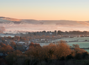
Saturday will be mostly cloudy in the far northeast, with outbreaks of rain at times and perhaps some lingering rain in the far east during the morning. Central and eastern areas will enjoy drier and sunnier spells, while coastal regions exposed to the north and west will see showers, some of which may be heavy, though less intense than on Friday. Over the Scottish mountains, some of these showers will fall as snow.
Winds will be brisk for most, with gales or locally severe gales possible along North Sea coasts. Temperatures will feel cold, with maximum values ranging from mid to high single figures in the north, near or below freezing over high ground above 400 to 500 metres, to around 12°C in some sheltered southern coastal areas.
A weekend of two halves 🌦️
— Met Office (@metoffice) October 24, 2025
Sunny spells for many of us on Saturday with scattered coastal showers, but cloudier skies will bring widespread rain through Sunday ☔ pic.twitter.com/atrNmyzEpu
Saturday night will remain breezy, with further showers in the north and west, but elsewhere it will become mainly dry and clear. Patchy frost is likely, especially in northern and upland areas.
Outlook for Sunday
Sunday begins dry for most, with clear or sunny periods. Showers will persist in northern and western coastal areas, and the far northeast may see showers throughout the day. Cloud will steadily increase from the west, with outbreaks of rain moving southeastwards later—locally heavy and persistent on some west-facing hills, but not reaching the southeast until early evening.
Winds will be strong at first, with early gales for much of the North Sea coast, especially the Northern Isles, where gusts in showers may reach severe gale force. Winds will moderate through the day, but become strong again in the west and southwest by evening. It will be a chilly start, and temperatures will remain largely cold, especially in the north.
Met Office presenter and meteorologist, Alex Burkill, said: "It is going to feel pretty chilly first thing this morning. And actually, as we go through Saturday, a chilly feel for sure. Starting off a bit cloudy, bit damp across eastern parts of England, but that rain clears away towards the North Sea. And then actually a good deal of fine and often quite sunny weather around, albeit still seeing some of those showers piling down from the north on that cold Arctic air.
"And because that is Arctic air, we are seeing our temperatures dropping. And with that, the potential for some sleet or snow over modest high ground of Scotland. We're talking above 3 to 400 m. We could see some sleet and snow perhaps uh and elsewhere. Well, the higher ground is kind of sheltered from that northerly wind across parts of England. And so, as a result, I'm not really expecting much of any sleet or snow in other places, perhaps just a little bit over Snowonia. But, generally lots of places having a lot of fine weather, just some showers continuing to come down from the north.
"Temperatures tomorrow are going to be a little bit lower than today. So whilst there'll be a bit more sunshine on offer, it is probably going to feel a little bit chillier, especially because there is still going to be some brisk winds. It's going to be quite blustery, especially towards some North Sea coastal parts here. There's the potential for gales. So feeling pretty raw indeed."