
Unsettled weather to continue
The weekend will continue unsettled across the UK, with further, potentially impactful, wet and windy conditions expected into next week.
A yellow warning for rain for Monday 8 December has been issued for parts of the south and central England and South Wales, as another area of low pressure brings the potential for disruption to parts of the country.
Weekend Weather Outlook
After a week of changeable conditions, further bands of rain and blustery winds are moving across the UK this weekend.
Will you need your winter woolies or waterproofs this weekend? 🧣
— Met Office (@metoffice) December 5, 2025
Whether you're braving some Christmas shopping or visiting a market, here's how the weather will fare 🎄👇 pic.twitter.com/YUEyfWgWmL
Saturday: Gusty winds and frequent showers
Bands of showers will be most persistent across south Wales and northwest England Saturday afternoon, and some of these will be heavy with a chance of the odd rumble of thunder. The ground in some of these areas is already saturated, so any extra heavy downpours will be far from welcome, potentially leading to tricky travel conditions and localised surface water issues.
As Saturday ends, attention turns to the next weather system approaching from the west, set to bring another spell of rain from west to east overnight.
Sunday: Rain clearing, brighter spells, and milder air
Sunday begins on an unsettled note for many, with a band of rain arching its way north-eastward and spreading steadily across most of the UK. This rain will be persistent for a time, again falling on saturated ground in places, but will clear to leave a drier end to the day across much of England and Wales.
Disruptive weather next week
After a showery start to Monday, an approaching area of low pressure over the North Atlantic will bring heavy rain and strong winds from late Monday into Tuesday. A yellow warning for rain has been issued for Monday, affecting parts of Wales, south and southwest England, and the southwest Midlands.
⚠️ Yellow weather warning issued ⚠️
— Met Office (@metoffice) December 6, 2025
Rain across southern parts of Wales and southwest England
Monday 1800 – Tuesday 1800
Latest info 👉 https://t.co/QwDLMfRBfs
Stay #WeatherAware⚠️ pic.twitter.com/afnXeuSTLn
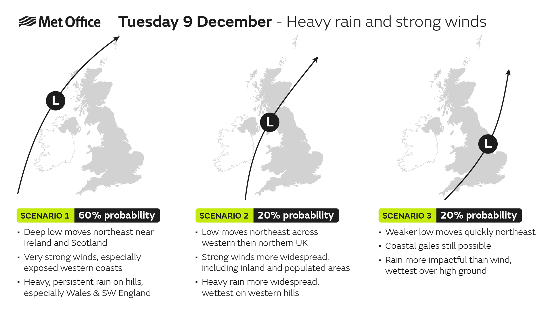
Met Office Deputy Chief Meteorologist Dan Holley said: “The area of low pressure responsible may undergo fairly rapid deepening just as it approaches the UK, which often leads to lower confidence in its exact track and depth. This can have significant impacts on which areas experience the strongest winds and heaviest rain.
“However, it is quite likely many parts of the UK will experience spells of rain which, given how saturated the ground is, could lead to some flooding with delays to road and rail travel.
“In addition, some very strong winds will be possible, particularly in northern and western parts of the UK. We are closely monitoring developments and will update forecasts as the situation evolves. A yellow warning for rain has already been issued, and further warnings may be needed as confidence increases.”
The below scenario graphic shows our current thinking
Further ahead
The outlook for much of December remains unsettled, with further areas of low pressure expected to bring more wet and windy weather. It is too early to provide details for Christmas, but updates will be posted across Met Office channels as we get closer to the time.
Keep up to date with the latest forecast for your area using our forecast pages. You can also follow us on Twitter and Facebook. Use our mobile app which is available for iPhone from the App store and for Android from the Google Play store.