Amber warning for further snow in Scotland
Snow will fall on already impacted areas bringing further disruption as more unsettled weather moves in from the west.
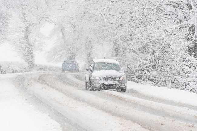
A complex mix of snow, heavy rain, strong winds and possibly freezing rain will mark an end to the cold spell that has been in place across the UK since the start of the year. A low pressure system to the northwest of the UK will drive milder air and strong winds across the UK on Sunday. With cold air in place across the north, snow is likely to accumulate before turning to rain later on Sunday. For Northern Ireland, Wales and the southern half of England this will largely fall as rain.
Within the Amber warning area in eastern Scotland snow accumulations of 5-15cm are likely at relatively low levels with potentially up to 20-30cm over higher elevations within the Highlands and Aberdeenshire. A much wider Yellow warning for snow and ice covers the majority of Scotland as well as much of northern England. While snow accumulations are to be lower here, there is still a chance of 2-5cm at low levels and temporarily 10-20 cm over higher ground before snow turns to rain later in the day.
⚠️⚠️ Amber weather warning issued⚠️⚠️
— Met Office (@metoffice) January 10, 2026
Heavy snow across parts of Scotland
Sunday 03:00 – 14:00
Latest info 👉 https://t.co/QwDLMfRBfs
Stay #WeatherAware ⚠️ pic.twitter.com/ZrrFc3dnEY
As milder air progresses eastwards, rain becomes more of a hazard, with Yellow rain warnings issued for western and northern Scotland, southwest Scotland and Northern Ireland. 80-100mm of rain could accumulate in the western Scotland warning area through Sunday and into Monday, which along with snow melt could cause some flooding impacts. In Northern Ireland accumulations could reach 40-60mm over higher ground.
As snow transitions to rain there is a risk of some freezing rain for a time, especially across parts of east Scotland and northeast England. Where this occurs, it could lead to ice forming very quickly on all surfaces.
It’ll be a windy day too, with the strongest gusts across Scotland and along the coasts of Northern Ireland. A Yellow warning for wind has been issued, warning for gusts of 45-60mph widely with 70mph gusts possible in the Western Isles and Northern Isles.
Met Office Chief Forecaster, Rebekah Hicks, said: “Sunday will see a disruptive spell of weather as the UK transitions into a milder air mass, marking an end to the cold spell we’ve had since the start of the year. Low pressure will drive milder air in from the west and where this interacts with the cold air, we’ll see notable snow accumulations in already impacted areas of Scotland. Parts of the Highlands could see a further 20-30cm of snow. This will coincide with strong winds, making Sunday an impactful day of weather.
“Snow will turn to rain through the day, with the possibility of freezing rain for a time which could lead to some extremely hazardous conditions with ice forming instantly on all surfaces. With heavy rain and snow melt as temperatures climb, there is a risk of flooding in some areas too.
“With numerous severe weather warnings in place, it is important to stay up to date with the forecast as well as information from local responders and authorities.”
Flood risk
The Scottish Government’s Resilience Room (SGORR) met again on Saturday as agencies continue to deal with the impact of sustained cold and wintry weather across much of northern Scotland and other parts of the country.
Scottish Cabinet Secretary for Justice & Home Affairs, Angela Constance, said: “At today’s SGoRR meeting the Met Office advised partners how we are facing a complicated multi-hazard event, affecting various parts of the country in different ways and at different times over Sunday and into Monday. It involves various combinations of continued snowfall, milder conditions leading to snowmelt, and with heavy rain in some areas leading to a flooding risk from Sunday afternoon.
“Given that complexity I was reassured to hear how partners remain stood up and are working tirelessly across the weekend to continue supporting communities and to respond as the conditions and the nature of the hazards change.
“I am grateful for the work of partners, from frontline responders and agencies to contractors, voluntary groups and individuals who have worked so hard to respond to the impacts of this prolonged period of heavy snowfall and other wintry weather.
“The sustained nature of this weather event, and the different elements of it, are clearly very challenging for communities and responders alike, given the difficulties already caused by the weather since the start of the year.
“As ever, I would encourage people to follow the advice for their local area provided by key agencies, online and on social media, including from the Met Office, SEPA and Police Scotland and to plan ahead for the coming days.”
Pascal Lardet, SEPA Flood Duty Manager, added: "With rainfall forecast to move into south west Scotland on Sunday and then spread north and as temperatures rise following recent cold conditions, rain and thaw of lying snow from Sunday onwards will increase the risk of flooding. Possible impacts could include flooding of low lying land, roads and individual properties. Keep up to date on the latest information by checking our three-day Scottish Flood Forecast ."
People are encouraged to sign up to the Floodline service to receive free updates for where they live, or where they’re travelling through, directly to their phone. People can also check flood updates for all the latest updates and have a look at the three day Scottish Flood Forecast to see what’s expected further ahead.
Advice for severe weather
With multiple types of severe weather impacting the UK over the next couple of days, the Met Office’s WeatherReady campaign offers practical advice to help you prepare your home, garden, and daily routines for winter weather.
With strong winds, snow and ice accretion there is a chance of some power outages. People cope better with power cuts when they have prepared for them in advance and it's easy to do. The essentials that could help you cope with a power cut are:
- candles and matches or lighters,
- torches and batteries,
- a mobile phone power pack
If your power goes out these simple steps can help you deal with the situation:
- Switch off all electrical appliances that shouldn’t be left unattended, ready for when the power comes back on.
- Leave a light on, so you know when the power cut has been fixed.
- Check to see if your neighbours are safe and if they have a power cut too. If they have power, your trip switch may have activated.
- Wrap up. If it's cold, wrap up warm and close internal doors to keep the heat in.
- Portable heaters are a good alternative if heating systems are down.
- Call 105 for information, it’s a free service for people in England, Scotland and Wales.
Take time to check if your property is at risk of flooding through SEPA, the Environment Agency, Natural Resources Wales and NI Direct.
Saturday weather
Before this spell of disruptive weather, conditions have improved after Storm Goretti, with a brighter and more settled day for many on Saturday. Wintry showers, with snow on high ground, will continue to affect parts of north and northwest Scotland until later in the day.
Turning milder next week
Strong winds will continue into Monday morning in Northern Ireland and western Scotland where gusts of 60-70mph could bring further disruption to the start of the week, a Yellow warning for wind has been issued for Sunday night and through Monday morning. After this, temperatures will return closer to average for most through next week, with a south-westerly regime dominant. This also brings with it the likelihood of further unsettled weather at times with a risk of further heavy rain in places.
You can find the latest forecast on our website, on YouTube, by following us on X and Facebook, as well as on our mobile app which is available for iPhone from the App store and for Android from the Google Play store.