Wet and windy weather expected over the Easter Weekend
The weather will be changeable this week, briefly becoming more settled before things turn more unsettled again by the Easter Weekend, with the increasing likelihood of wet and windy weather for some.
Ahead of that, milder air moves in today, bringing what’s likely to be the warmest day of the week, with highs of 16-17°C possible in the south, and values in the low to mid-teens for many. It will feel cooler in the far north, where it will also be windy.
A fairly benign week ahead, but often cloudy ☁️
— Met Office (@metoffice) March 30, 2026
Turning increasingly unsettled over the Easter weekend though 👇 pic.twitter.com/0sEdeZboBD
Wednesday will be a mainly cloudy day, with bands of rain over northern Scotland moving south and eastwards across the day before easing. Temperatures will be down slightly on Tuesday’s values.
Things brighten up on Thursday, with a patchy frost possible in the north first thing. A band of cloud and rain, along with stronger winds, is then likely to move in across parts of the north and west.
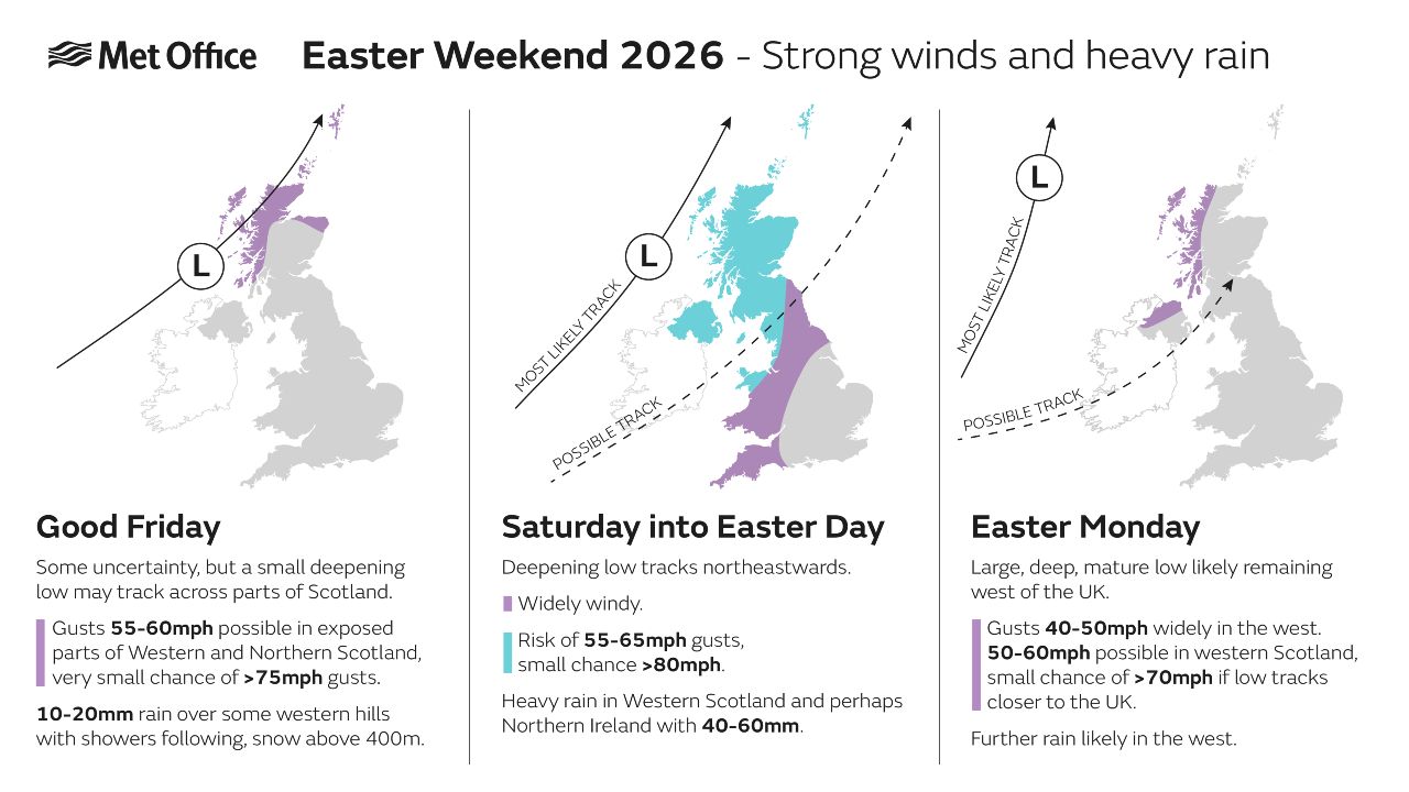
An unsettled Easter Weekend
Conditions are likely to turn more unsettled as we head into the Easter Weekend, with low pressure likely to dominate.
Met Office Deputy Chief Meteorologist, Steven Keates, said: “As we head into Good Friday and Easter Saturday, the weather is expected to turn more unsettled, with spells of rain at times, some of which could be heavy. This will be followed by sunny spells and showers, with the driest conditions likely towards the southeast of the UK.
“It is also likely to become windy at times across all areas, particularly in exposed north-western locations. While there remains some uncertainty in the detail at this point in time, there is a strong signal for wet and windy conditions to continue into the Easter Weekend.”
READ MORE: Easter weather extremes: the records behind a famously changeable weekend
You can find the latest forecast on our website, on YouTube, by following us on X and Facebook, as well as on our mobile app which is available for iPhone from the App store and for Android from the Google Play store.