Storm Ciara named by Met Office
Author: Press Office
11:04 (UTC) on Wed 5 Feb 2020
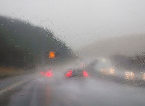
Storm Ciara will bring heavy rain and widespread gales to the UK this weekend.
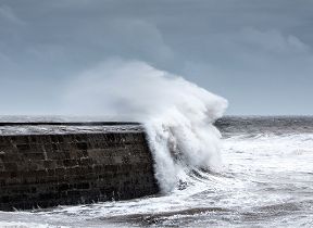
Named by the Met Office on Wednesday, the low-pressure system is currently developing in the North Atlantic and will track eastwards towards the UK and Ireland over the coming days. Over the weekend wind gusts will widely reach 50-60 mph across many inland areas, with gusts of 80 mph or higher in coastal areas and exposed locations.
The Met Office has issued several National Severe Weather Warnings for wind starting from Saturday for north-western areas, then covering the whole of the UK by Sunday. Warnings for strong winds and snow are also in place for north-western areas on Monday and Tuesday. Storm Ciara is expected to bring a range of impacts, including delays and cancellations to transport services, damage to power supplies and large coastal waves.
Frank Saunders, Chief Meteorologist at the Met Office said: “An extremely strong jet stream will steer a succession of low-pressure systems towards the UK over the next week, starting with Storm Ciara this weekend. Our confidence in the forecast means we have been able to issue severe weather warnings well in advance, giving people time to prepare for potential impacts of the storm.”
Before Storm Ciara arrives, high pressure will bring largely fine conditions to most of the UK on Thursday and Friday. It’ll stay dry with bright spells across eastern parts of the UK on Saturday, but it’ll turn more unsettled in the west with strengthening winds ahead of Storm Ciara.
Chief Meteorologist Frank Saunders continued: “The Met Office will continue to monitor the development of Storm Ciara and other potentially impactful low-pressure systems through next week. Warnings will be issued and amended as appropriate so members of the public should keep up to date with the Met Office forecast via our website, app or by following us on social media.”
Storm Ciara is the third named storm of the season which started in September. The naming convention now also includes the Dutch meteorological service, KNMI as well as existing partner Met Éireann. Storms are named to aid the communication of approaching severe weather, helping the public to be better placed to keep themselves, their property and businesses safe.
In the wake of Storm Ciara, it’ll remain unsettled and very windy across the UK and it’ll turn colder with wintry showers and ice an additional hazard, as we head into the new week.
You can get the most accurate and up to date forecast for your area using our forecast pages and by following us on Twitter and Facebook, as well as using our mobile app which is available for iPhone from the App store and for Android from the Google Play store.
Updated at 11:41 (UTC) on Thu 6 Feb 2020