Unsettled week ahead
Author: Press Office
11:04 (UTC) on Tue 22 Feb 2022
It will remain unsettled this week, but the risk of further impacts from wind and rain is much lower than we have seen in recent days, particularly across the south.
Met Office Chief Meteorologist, Steve Willington, said: “A strong jet stream is driving weather systems across the North Atlantic Ocean with a succession of weather fronts moving into the UK bringing more wet and windy weather at times this week.”
“Once Storm Franklin cleared the UK a band of rain and strong winds pushed into the northwest. This weather front is moving south and east today petering out as it does so. Behind the rain there is another spell of sunshine and showers, some of which could be wintry over the hills in the north.
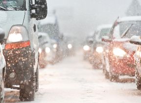
Showers will, once again, move into the north and west on Wednesday bringing more wind and a band of heavy rain which could fall as snow or sleet over the hills, but also to lower levels at times. A number of yellow National Severe Weather warnings have been issued for both wind and snow. The rain and blustery conditions will push south and east through the day. Away from the weather front it will be mainly dry, blustery and sunny for many.
There will be a frosty start for some on Thursday. Gusty winds and heavy rain continue to move south and east across the country, clearing the Southeast of England by late morning. Wintry showers are expected mainly over the hills in the north again, but there could be some snow to low levels at times.
The weather is expected to be more settled on Friday before another windy spell, especially in the north, heralds the start of the weekend.
We are expecting to issue further National Severe Weather warnings this week, but the risk of impacts is lower than we have seen in recent days. Check the latest forecast for your area on our website, by following us on Twitter and Facebook, as well as on our mobile app which is available for iPhone from the App store and for Android from the Google Play store. Keep track of current weather warnings on the weather warning page.
For more information on how to prepare for severe weather, please visit our WeatherReady advice.