Amber warning issued as snow risk continues
Author: Press Office
11:09 (UTC) on Wed 17 Jan 2024
An Amber warning has been issued for northern parts of Scotland as winter hazards continue to dominate the UK weather.
Cold Arctic air remains dominant over the UK, with snow and ice likely to continue ahead of the weekend for many in the northern half of the country, including Scotland, Northern Ireland, parts of northwest and southwest England, and north and west Wales.
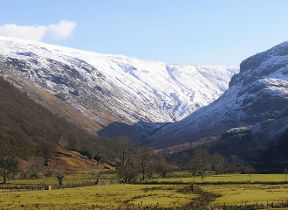
A number of Met Office weather warnings are in force on Wednesday and Thursday. An Amber warning for snow has now also been issued for northern parts of Scotland, where high ground could see in excess of 40cm of snow accumulate before the weekend. Lower ground in the north of Scotland is more likely to see 5-10cm of lying snow accumulate ahead of the weekend.
⚠️⚠️ Amber weather warning issued ⚠️⚠️
— Met Office (@metoffice) January 17, 2024
Snow across the Northern Isles and northwest Scotland
Wednesday 1500 – Thursday 1800
Latest info 👉 https://t.co/QwDLMfRBfs
Stay #WeatherAware ⚠️ pic.twitter.com/01MinDteIu
Met Office Chief Meteorologist Jason Kelly said: “With deep snow already lying on the ground for many in the northern half of the UK, we’re going to see a significant topping up of totals over the next couple of days, especially for those in the north of Scotland.
“Within the Amber warning area, an additional 15-20cm of snow is possible in a few locations. Strengthening northwesterly winds will also cause some lying snow to drift, potentially bringing some additional hazards, such as temporary blizzard conditions.”
Met Office warnings highlight the ongoing likelihood of travel disruption, the possibility of power cuts and the chance that some rural communities will be cut off. Temperatures will remain below average until Friday for many, with overnight temperatures likely to be -3°C or -4°C for many in the UK, and even lower where there’s lying snow.
Minister for Transport for Scotland Fiona Hyslop said: “We know from recent severe weather events that it’s important to plan ahead if you are looking to travel. With the Met Office issuing an updated amber warning for snow in the North Highlands and Northern Isles, travel planning becomes vital.
“Police Scotland is warning of a high risk of disruption for the parts of the country covered by the amber warning, but yellow warnings can also be impactful and cause delays. Please allow extra time for your journey and consider if it can be delayed until conditions have improved.
“Winter resilience plans have been in full effect with teams across Scotland working overnight to grit the trunk road network for essential journeys. Local roads may also be impacted, so please make sure your route is available, follow the travel advice from Police Scotland and drive to the conditions.
“The latest information on the trunk road network is always available at www.traffic.gov.scot. If you are planning to travel by train, ferry or plane, please check with your operators as the forecast conditions could also impact your services.”
The UK Health Security Agency has a Cold-Health Alert in force for England, which highlights the possibility of significant impacts for the health and the social care sector.
Dr Agostinho Sousa, Head of Extreme Events and Health Protection at UKHSA, said: “The temperatures we will see can rapidly have a serious impact on the health of those over the age of 65 and those with pre-existing health conditions as it increases the risk of heart attacks, strokes and chest infections. It is therefore vital to check in on friends, family and neighbours to ensure they are well prepared for the cold weather this week.”
A change is on the way
The cold Arctic air currently in place over the UK will start to be displaced from the south from Friday, with a return to milder Atlantic air from the west.
However, while temperatures will increase from the markedly low figures of recent days, this change in airmass will also introduce the likelihood of a return to wet and windy weather for most through the weekend.
A marked contrast in temperatures is leading to a powerful jet steam over North America and spinning up low pressure systems 👇 🌀 pic.twitter.com/ZjkrtT2fmu
— Met Office (@metoffice) January 16, 2024
Met Office Deputy Chief Meteorologist Dan Rudman explained: “While the next few days will remain cold, we can see a change in weather type on the way, bringing milder air for the UK and returning temperatures to around average for the time of year from Friday onwards and well above average into next week.
“This change will initially be relatively benign in terms of weather impacts, with a dry Friday and start to Saturday for many in the south of the UK. The Atlantic influence will then introduce some wet and windy weather, with a deep area of low pressure approaching from the west on Sunday. While detail is still being worked out, this has the potential to bring heavy rain and strong winds for some, and we’ve issued an early warning for a large part of the UK.”
Warnings are likely to be reviewed and amended in the run-up to the weekend as certainty of impacts increases, so it’s important to stay up to date with the latest Met Office forecast.
The exception to the benign start to the weekend is in northern and western Scotland, with showers likely to continue on Friday and Saturday, likely continuing to fall as snow over high ground.
You can keep up to date with the latest forecast on our website, by following us on Twitter and Facebook, as well as on our mobile app which is available for iPhone from the App store and for Android from the Google Play store.

Updated at 13:11 (UTC) on Wed 17 Jan 2024