
Weather warnings play a vital role in helping people across the UK prepare for and respond to severe weather.
Issued by the Met Office through the National Severe Weather Warning Service (NSWWS), these alerts are designed to inform the public, businesses, emergency responders and government agencies about potential weather-related impacts.
But what do the colours of these warnings actually mean, and how are they decided?
The purpose of weather warnings
The Met Office operates 24 hours a day, 365 days a year to monitor and forecast weather conditions. When severe weather is expected to bring disruption or danger, a warning is issued to help people make informed decisions and take appropriate action. These warnings are not just based on the weather itself, but on the potential impacts and how likely those impacts are to occur.
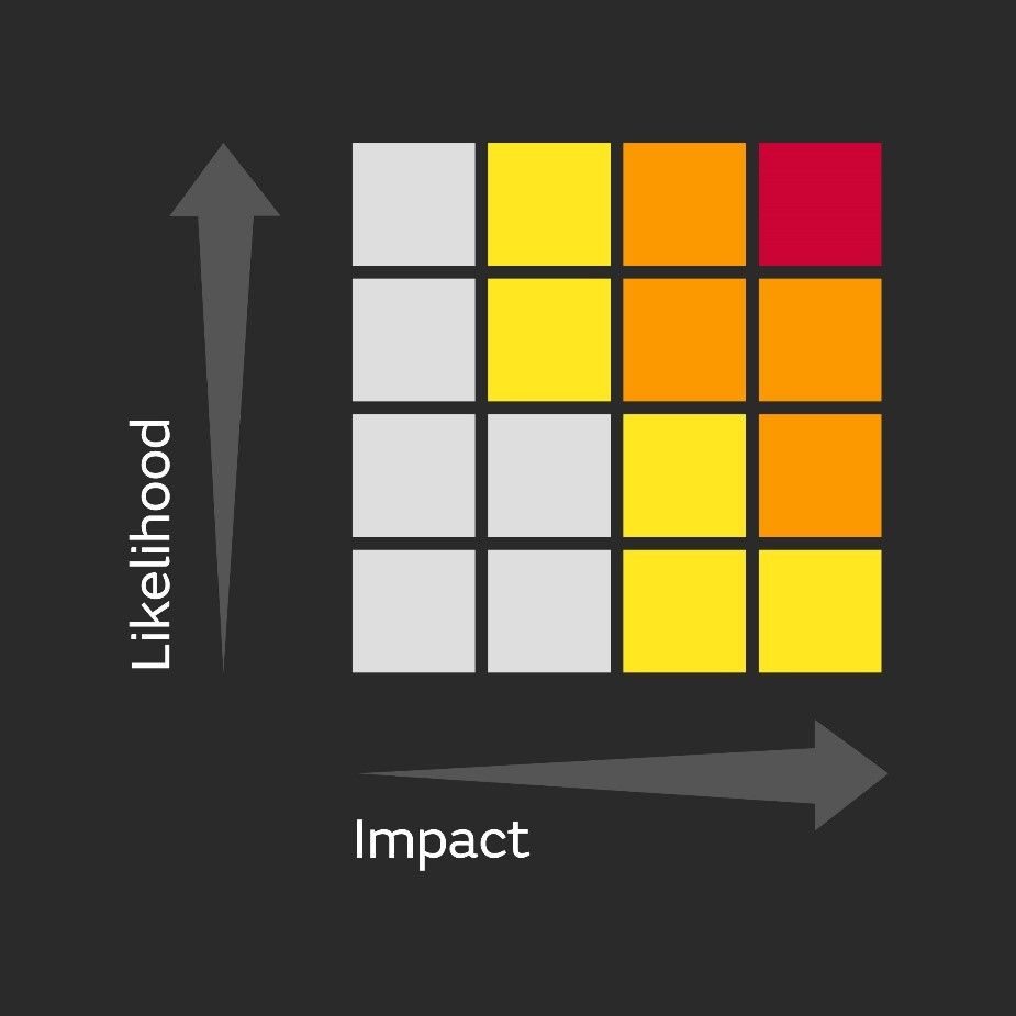
How colour categories are determined
Weather warnings are categorised into three colours: yellow, amber and red. These colours reflect a combination of two key factors:
- Impact level: What kind of disruption or danger the weather could cause.
- Likelihood: How probable it is that those impacts will happen.
This approach ensures that warnings are not only about the severity of the weather, but also the level of confidence forecasters have that it will affect people’s lives. The Met Office uses an impact-likelihood matrix to determine the appropriate colour for each warning. This matrix, available in the “Further Details” section of every warning, shows the assessed combination of impact and likelihood.
READ MORE: Why has it been so warm and humid recently?
Yellow warning
Yellow warnings are issued for a wide range of weather scenarios. They may indicate low-level impacts that could cause minor travel disruption or affect a few people. In other cases, they may signal potentially severe impacts, but with lower confidence that those impacts will occur.
Because yellow warnings cover a broad spectrum, it’s important to read the full details to understand the specific risks in your area. While many people may be able to go about their day as usual, others could be directly affected and should take precautions.
Amber warning
Amber warnings suggest a higher likelihood of significant impacts. These could include travel delays, road and rail closures, power outages and even risks to life and property. When an amber warning is issued, it’s advisable to consider changing your plans and taking steps to protect yourself, your family and your community.
This level of warning indicates that the weather could cause widespread disruption, and emergency services may be under increased pressure to respond.
Red warning
Red warnings are reserved for the most dangerous weather events. When a red warning is issued, it means that severe impacts are very likely, and action is required to stay safe. This could involve avoiding travel, securing property, and following advice from emergency services and local authorities.
Red warnings often signal a risk to life, extensive damage to infrastructure, and prolonged disruption to essential services such as transport and energy.
READ MORE: Climate change impacting the natural world
Understanding impact levels
Each warning is also assigned an impact level, very low, low, medium or high, which helps to further clarify the expected severity:
- Very low: Minimal disruption, with only isolated impacts.
- Low: Some short-lived disruption, manageable under normal conditions.
- Medium: Noticeable disruption with potential danger to life and strain on emergency services.
- High: Widespread and prolonged disruption, significant danger to life, and major impacts on infrastructure and services.
By combining impact and likelihood, the Met Office ensures that weather warnings are not only accurate but also meaningful. This approach helps people understand not just what the weather will be, but what it could do, and how likely it is to happen. Whether it’s a yellow alert for patchy snow or a red warning for a major storm, each colour carries vital information to help you stay safe and be prepared.
The Met Office is also continually reviewing and refining its weather warnings to reflect the UK’s changing climate and the evolving ways weather impacts our lives. Since moving from threshold-based to impact-based warnings in 2011, we’ve introduced new categories such as the thunderstorm warning in 2018 and the extreme heat warning in 2021, ensuring our warnings remain relevant, timely, and effective in helping people stay safe and thrive.
Keep up to date with weather warnings, and you can find the latest forecast on our website, on YouTube, by following us on X and Facebook, as well as on our mobile app which is available for iPhone from the App store and for Android from the Google Play store