Met Office daily weather: Unsettled with showers and blustery winds
September begins with heavy rain mixed in with some sunny spells
Monday will begin with some heavy bursts of showery rain, particularly affecting parts of Scotland, north-west England and Wales. Elsewhere, expect a mix of sunny spells and showers, some of which may be heavy and accompanied by isolated thunderstorms or hail.
Winds will be brisk, especially in and around showers, contributing to a distinctly blustery feel. Temperatures will be slightly lower than those recorded on Sunday, with maxima generally near the seasonal average. The warmest spots are likely to be found across eastern and central England and along the Moray coast, where highs could reach 20–22°C.
During the evening, showers will gradually become confined to northern and north-western areas, as well as the far south and south-east. Later in the night, more persistent and occasionally heavy rain, with a risk of thunder, will move into the south-west. Winds will ease across central parts of the UK but will strengthen again in southern and south-western regions.
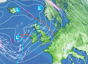
As we step into meteorological autumn this week, what can we expect from the weather?
— Met Office (@metoffice) August 31, 2025
Here's how things are shaping up 👇 pic.twitter.com/Hn2pb56kuU
Overnight temperatures will be cooler than the previous night, with minima widely in the high single or low double figures Celsius, typical for early September.
Outlook for Tuesday
Tuesday will start bright in eastern areas, while cloud and rain, some heavy at times, will spread from the south-west across Wales and the southern half of England. These will be followed by heavy showers and a risk of thunder over southern England. Northern England, Northern Ireland and Scotland will see sunny spells and scattered showers. Winds will be less pronounced than in recent days, and temperatures will be close to or just below average for the time of year, with highs of 20–22°C in the east and south where conditions improve after the rain, and 17–19°C elsewhere.
Showers will persist in the north-west overnight, while further south, rain and showers will fade to leave clear spells for a time. However, cloud and rain, again heavy at times, will redevelop over much of England and Wales during the early hours, with winds strengthening and coastal gales possible in southern areas. Temperatures will be cooler in the far north and mild elsewhere.
Met Office presenter and meteorologist, Craig Snell, said: “It's a wet start to autumn across parts of the UK this morning, especially so for Scotland. We do have this band of heavy rain around. Some poor traveling conditions in places. Lots of surface spray on the roads. That rainband does clear away as we go through the course of the day, however, and for most of the UK really, it's going to be a day of sunny spells and scattered showers.
“Some of these showers will be quite heavy and thundery and quite blustery, too. We've got this brisk wind around. The winds will be slightly lighter than they were on Sunday, but overall still a fairly breezy picture out there. But in the brighter moments, it won't feel too bad for the beginning of September. We will see highs potentially up to about 20°C or 21°C across more southern and eastern parts of the UK.
Into this evening, the showers across the east will generally begin to fade away, allowing some clearer skies to develop here. But further west, the showers will continue to pile in. And then later on in the night, a more persistent band of rain arrives into the far southwest. And some of this rain could be on the heavy side.
“So, for most of us, Tuesday starts off on a fairly cheery note with some sunshine around, but not so down towards the southwest. We've got this band of rain and that will spread its way eastwards across many parts of England and Wales. Again, some of the rain will be quite heavy and persistent and some places actually seeing a fairly wet picture during the course of the day for Scotland, Northern Ireland, the far north of Northern England. And again, some of these showers will be on the heavy side. Maybe some brightness returning later on in the day across the very far southwest. So overall temperatures fairly similar to today. Highs ranging between around 16 to 20°C across the UK.”