Met Office daily weather: East-west weather split as we head towards the weekend
Thursday and Friday will bring a contrast in conditions across the UK
Thursday and Friday will bring a contrast in conditions across the UK.
Eastern parts, particularly East Anglia and southeast England, will remain rather cloudy and cool with outbreaks of rain and drizzle on Thursday. There is some uncertainty around the extent of this rainfall, but heavier bursts are possible across East Anglia during the day.
Elsewhere, most areas will stay dry with variable cloud and warm sunny spells, especially across western and central regions. Some light rain or drizzle is expected across northern Scotland, and a few light showers may develop over high ground, though these will be isolated.
Temperatures will be notably warmer in the west, with highs of 23-25°C likely across the West Midlands, central southern England, and the West Country. Isolated spots may reach 26°C. Southeast Scotland may also see local highs of 23°C. In contrast, eastern and southeastern England will remain cooler under cloudier skies, though the exact westward reach of this cooler air remains uncertain.
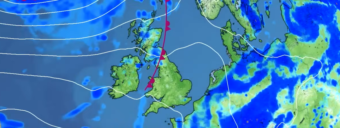
After some relatively settled weather over the next couple of days, more changeable conditions are expected as we head into the weekend...👇 pic.twitter.com/Z0hm65gbrV
— Met Office (@metoffice) July 23, 2025
Rain across eastern and southeastern England will gradually fade through the evening, leaving most areas dry overnight. Variable cloud and clear spells will develop, with a few fog patches forming in rural areas. Later in the night, a band of cloud and light rain or drizzle will edge into the far northwest.
Outlook for Friday
Friday will see a weakening band of cloud and patchy rain moving eastwards across the UK. This will bring mostly light rain or drizzle, primarily affecting western areas. Ahead of this, much of the south and east is expected to remain dry with sunny spells.
As the front clears, clearer skies will follow, although some showers are likely in the northwest, where winds will freshen and become blustery at times. Winds elsewhere will remain light to moderate.
Temperatures will be rather warm or warm in the east and southeast, with highs potentially reaching 28-29°C. Elsewhere, temperatures will be closer to average for the time of year.
Met Office presenter and meteorologist, Jonathan Vautrey, said: “It'll be a touch fresher in some rural areas to kick off Thursday morning. As we head into the morning, we will start to see more rain just arriving for parts of eastern England. Some uncertainty with regards to how far west this could spread, but certainly for parts of East Anglia, eventually down towards London, we may start to see the odd heavier burst of rain for a time.
READ MORE: Met Office Deep Dive: Why are summer downpours so slow moving?
“The rest of the sunshine will be further towards the west where it should be a relatively fine day to come here. That difference in conditions will also influence our temperatures. Certainly, under the cloudier skies across the southeast of England, temperatures will be held back here with a slightly cooler feel and a brisker breeze in place. But with light winds and sunshine across the west, temperatures will again be climbing into the low to mid 20°C. It's all changed though as we head into Thursday evening.
“Whilst the rain in the southeast will tend to ease off and fizzle away, we'll start to see the cloud thickening for parts of Northern Ireland and western Scotland as a band of rain slips in here. This is all associated with a weather front that's going to push its way into the northwest of the UK for the end of Thursday and into Friday. Meanwhile, we've got a ridge of high pressure that will build in across the southeast. And for Friday, it's a reversal of fortunes with the slightly wetter and damper conditions up towards the northwest and the clearer and brighter conditions down towards the southeast.”
Keep up to date with weather warnings, and you can find the latest forecast on our website, on YouTube, by following us on X and Facebook, as well as on our mobile app which is available for iPhone from the App store and for Android from the Google Play store.