An unsettled weekend ahead of potentially disruptive weather next week
Low pressure will dominate this weekend, bringing wet and windy conditions for many. As we move into the new working week, there is potential for more disruptive weather and further weather warnings may be issued.
Persistent rain will spread from the west during Friday afternoon, along with some gusty winds.The highest rainfall totals from Friday into Saturday will be over high ground in south Wales, southwest England, Cumbria, southwest Scotland and Northern Ireland. 20-30 mm of rain is likely in these areas, most of which will fall in around 6-9 hours. Given how wet it has already been, the additional rainfall, especially in western areas, could lead to localised flooding and travel disruption.
Will you need your winter woolies or waterproofs this weekend? 🧣
— Met Office (@metoffice) December 5, 2025
Whether you're braving some Christmas shopping or visiting a market, here's how the weather will fare 🎄👇 pic.twitter.com/YUEyfWgWmL
Saturday: Gusty winds and frequent showers
Heavy rain from overnight lingers into Saturday, particularly across northeastern parts of Scotland. Elsewhere, many places will see blustery showers and a brisk south to southwesterly wind.
Bands of showers will be most persistent across south Wales and southwest England, and some of these will be heavy, with the odd rumble of thunder. The ground in some of these areas is already saturated, so any extra heavy downpours will be far from welcome, potentially leading to tricky travel conditions and localised surface water issues.
The best chance of any dry weather will be across parts of Northern Ireland, northeast England and southeast Scotland. Temperatures will be near normal to rather mild, tempered by brisk winds in the south.
As Saturday draws to a close, attention turn to the next weather system gathering to the west. This system is set to bring almost a repeat performance, with another weather front extending across the country from west to east.
Sunday: Rain clearing, brighter spells, and milder air
Sunday begins on an unsettled note for many, with a band of rain arching its way northeastward and spreading steadily across most of the UK. This rain will be persistent for a time, especially in the north, but will clear to leave a drier end to the day across much of England, Wales and Northern Ireland.
Chance of disruptive weather next week
After a showery day on Monday, attention turns to a potentially deep area of low pressure to the southwest of the UK. Deputy Chief Meteorologist Steven Keates explains: “A deepening area of low pressure will approach the UK from the southwest later on Monday, bringing with it heavy rain and strong winds, which are likely to affect the UK between late Monday and early Wednesday.
“At present, the exact track, depth, and timings of this low are uncertain, which makes it harder to determine where will be most impacted by strong winds and/or heavy rain. This system has the potential to cause disruption, and severe weather warnings are likely to be issued over the weekend as details become clearer. We therefore urge people to keep up-to-date with the latest Met Office forecast.”
The below scenario graphic shows our current thinking, which will evolve as the weekend progresses.
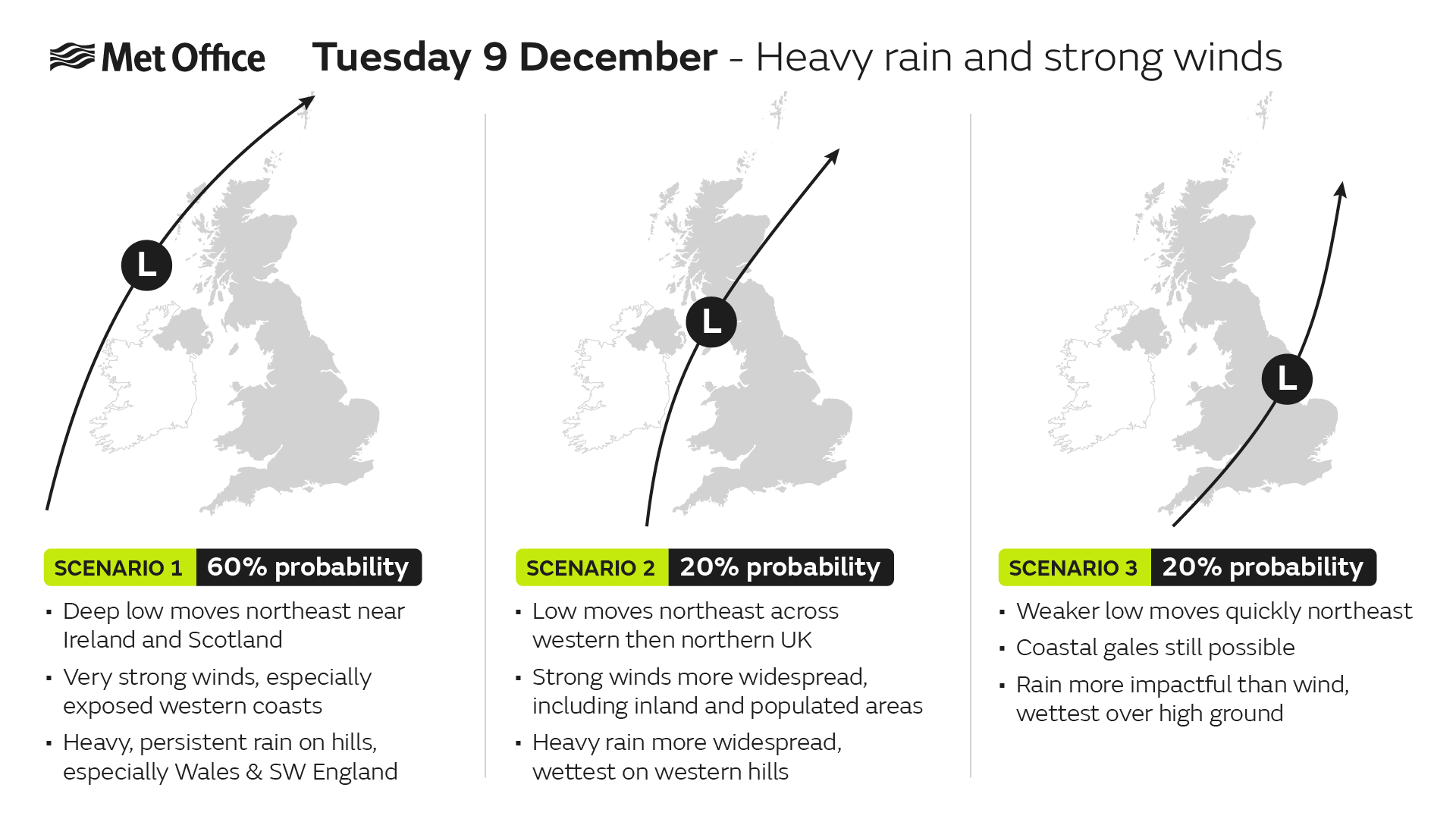
Scenario graphic showing chance of rain and wind early next week
Further ahead
The outlook through much of December remains unsettled, with a westerly influence bringing further areas of low pressure towards the UK. It is currently too far ahead to give any certainty over the weather for Christmas, but updates will be posted across Met Office channels as we get closer to the time.
Keep up to date with the latest forecast for your area using our forecast pages. You can also follow us on Twitter and Facebook. Use our mobile app which is available for iPhone from the App store and for Android from the Google Play store.