
An early look at the July statistics: just how dry has it been?
A prolonged heatwave, exceptionally low rainfall and widespread drought conditions have combined to make July 2026 a remarkable month.
Early provisional Met Office statistics, covering the period up to and including 30 July, show that both England and Wales are on course to record their driest July in 190 years, with several counties across England having seen less than 1mm of rainfall during the entire month so far.
With more than half of England and the entirety of Wales officially in drought, the month has been characterised by an exceptional combination of extreme heat, abundant sunshine and an almost complete absence of rainfall in some areas.
While one day of the month remains and figures are therefore subject to change, the emerging picture is one of a truly exceptional July, particularly across England and Wales.
Rainfall: England and Wales on course to record their driest July in 190 years
Provisional rainfall statistics to 30 July show:
- England is currently tracking its driest July on record, with just 5.6mm of rainfall recorded so far – just 8% of its long-term meteorological average for the month and less than half of the previous record of 13.4mm set in 1911.
- Wales is currently tracking its driest July on record, with 7.9mm of rainfall – just 8% of its long-term meteorological average for the month and almost a third of the previous record of 22.6mm set in 1911.
- The UK is currently tracking its third driest July on record, with only 35% of average rainfall – the driest July nationally since 1868.
- Northern Ireland is currently tracking its eighth driest July on record, with just 27% of average rainfall.
- Scotland has recorded 72% of average rainfall and is not currently within its top ten driest Julys.
Southern England has been particularly dry, seeing 1.5mm of rainfall – just 2% of its long-term average rainfall for the month.
Met Office Scientist Dr Emily Carlisle, said: "The headline story for July is undoubtedly the rainfall. Across parts of England and Wales we've seen extraordinarily low totals, with some locations recording little or no meaningful rainfall for much of the month.
“Provisional figures suggest this could be one of the driest Julys in nearly two centuries of records, which is particularly notable when coupled with the exceptional heat experienced so far this summer."
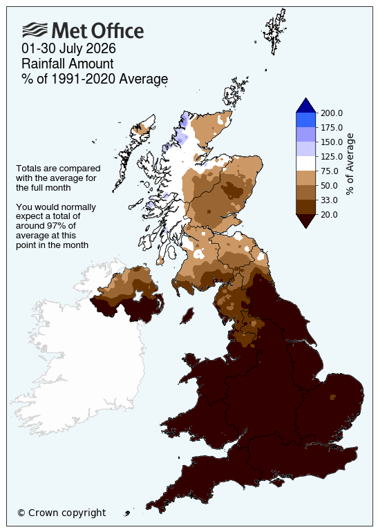
This map shows rainfall amounts from 1-30 July, compared with the average for the full month
Temperatures: continue to rewrite the record books in England and Wales
The dry conditions have been accompanied by exceptional warmth across much of the UK. Provisional statistics to 30 July show:
- Wales is currently tracking its warmest July for mean temperature on record.
- England is currently tracking its joint warmest July for mean temperature on record.
- The UK is currently tracking its second warmest July for mean temperature on record.
- Northern Ireland is currently tracking its third warmest July for mean temperature on record.
- Scotland has currently not seen mean temperatures within its top 10 on record.
Mean temperatures across southern England have been particularly high, at 3.2°C above average.

This map shows mean temperature for 1-30 July, compared with the average for the full month
Sunshine all round
The settled conditions also delivered above-average sunshine across much of the UK.
Provisional sunshine statistics to 30 July show:
- The UK is currently tracking its fourth sunniest July on record (since 1910).
- Wales is currently tracking its second sunniest July on record.
- England is currently tracking its second sunniest July on record.

This map shows sunshine hours for 1-30 July, compared with the average for the full month
Is there rain in the forecast ahead?
Fresher conditions have now extended across the UK and most areas will be fine with sunny spells over the weekend. Showers across Scotland on Saturday will ease by Sunday. From Monday, an area of low pressure will extend across the UK from the southwest bringing a spell of potentially heavy rain to parts of the north with showers in the south. This will also bring warmer and more humid air back across England and Wales, with 30°C likely to be exceeded again for some.
Met Office Chief Forecaster Chris Bulmer said: “A change in weather type early next week will see warmer conditions return across England and Wales but in contrast to much of the summer, this will be associated with showers or perhaps thunderstorms for some places. However, some parts of the south will only see small amounts of rain. It will stay cooler in the north with the potential for heavy rain to build up, especially over parts of Scotland.”
The full, provisional July 2026 statistics will be release by the Met Office on the afternoon of Monday 3 August.
Where does the monthly data come from?
The Met Office’s monthly climate statistics use HadUK‑Grid data to work out county, regional and UK‑wide averages. The dataset takes weather observations from across the country and interpolates them across the UK onto a 1km x 1km grid, covering every part of the UK. Some of these records stretch all the way back to 1836, meaning almost 200 years of weather data.
READ MORE: How do we know when weather records are broken?
READ MORE: What is HadUK-Grid?