Cold weekend ahead
Author: Press Office
15:47 (UTC) on Fri 18 Jan 2019
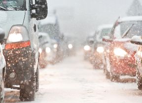
Cold weather is now affecting most of the UK and could last into February bringing winter hazards such as ice and snow.
The weather over the coming weekend is looking cold and rather cloudy with outbreaks of rain or sleet in places and slight snow accumulations over higher ground on Saturday and Sunday. Some of the rain could be heavy at times in the south-west. As we go into next week, there is a continued risk of wintry weather, including snow in parts of the UK.
Chief Meteorologist Andy Page said; “On Monday and early Tuesday, a band of heavier rain, hill snow and strong winds will move quickly south across the UK, followed by wintry showers for the middle of the week. Some of the showers will be heavy bringing a mixture of rain, hail, sleet and snow, most frequently across parts of the north and west.”
There are then strong signals for a change to northeasterly winds towards the end of next week. As we go through the rest of the month and into February the longer-range outlook indicates it will remain cold and possibly very cold for a time.
This will bring potentially widespread overnight frosts, which could be locally severe in any longer clear spells. With cold air across the UK there is a greater risk of snow at lower levels at times. However, some milder and wetter interludes may intersperse the generally cold conditions, these are most likely in the south.
Public Health England (PHE), following advice from the Met Office on the cold weather, has issued several cold weather alerts. Dr Emer O’Connell of PHE said: “Experience shows us that every winter thousands of people are seriously affected and even die from illnesses linked to the cold. Protecting yourself from the cold may seem like common sense but many people do not manage to keep themselves warm
“If you know someone at risk, someone over 65, anyone with dementia or a heart and lung condition, or a young child, check up on them and see if there’s anything you can do to help. All of us should be heating our homes to at least 18C, keeping up to date with weather forecasts and planning our days around them - simple steps can really help protect against the cold.”
As we reported a few weeks ago, a sudden stratospheric warming occurred at the end of December meaning the usual driver of our weather – the jet stream – is much weaker than usual for the time of year, which leaves the British Isles with an increased chance of settled weather and cold spells.
We advise the public to keep in touch with Met Office forecasts and warnings over the next few days and weeks so you can be prepared for the cold weather.”
Two thirds of British people have been caught out by severe weather according to latest research from the Met Office. To help them be better prepared for severe weather all year round, our ‘WeatherReady’ partnership with Cabinet Office provides expert advice on travel, protecting your home and your health and wellbeing.
You can find out the current forecast in your area using our forecast pages and by following us on Twitter and Facebook, as well as using our mobile app which is available for iPhone from the App store and for Android from the Google Play store.