Changeable weather to come after hot spell
Author: Press Office
12:31 (UTC+1) on Tue 7 Sep 2021
Much of the UK is currently in the midst of warm conditions for the time of year, with temperatures in excess of 30°C expected in some southern areas.
Only six Septembers in the last 50 years have experienced temperatures above 30°C, with three of those occurring in the last decade (2020, 2016, 2013). That warmth is no longer confined to the south as it was earlier in the week, with Scotland having a chance of hitting 28°C on Wednesday.
However, the conditions are expected to change for most over the next few days, as the southwest of the UK sees the first of a front moving in from the west.
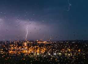
A yellow thunderstorm warning has been issued for a large part of the southwest on Wednesday. Although many areas will avoid the worst of the showers, thundery downpours are possible in the area and between 30mm and 50mm of rain could fall in less than three hours, although only a few spots are likely to see those totals. Elsewhere in the UK, and especially in the north and east, Wednesday will remain a fine, dry day with heatwave thresholds likely to be reached in some eastern parts of England.
⚠️Yellow weather warning UPDATED ⚠️
— Met Office (@metoffice) September 8, 2021
Heavy thundery downpours across SW England & south Wales today
Wednesday NOW-2100
Latest info 👇https://t.co/QwDLMfRBfs
Stay #WeatherAware pic.twitter.com/Q6iXf7SN27
Those showers and thunderstorms are expected to move northeastwards across the UK, bringing more widely unsettled weather through Thursday and Friday. A further yellow weather warning for thunderstorms has been issued on Thursday for Northern Ireland, Wales and parts of northern and central England. Once again, it's important to note there is a very low likelihood that any one location within the area will experience impacts from thunderstorms, but where the storms do occur up to 30mm of rain is possible in less than an hour which has the potential to generate some surface water flooding. There is also the possibility of very localised impacts from lightning and hail.
Beyond the warning areas, unsettled and showery conditions will be the main theme of the weather for Thursday and Friday.
Met Office Deputy Chief Meteorologist Dan Harris said, “The hot and clear weather currently being experienced across large parts of the UK is forecast to break down through the middle of the week as showers and thunderstorms arrive. These will initially affect the southwest of the UK on Wednesday, before moving steadily north and developing across most areas through Thursday and Friday.
“Thunderstorm warnings have been issued across a number of areas to highlight the potential for isolated impacts, including surface water flooding of homes and businesses, disruption to transport, and very isolated damage to infrastructure from lightning or hail. The semi-random nature of showers and thunderstorms means that many places will not see any thunderstorms at all, so it's not possible at this range to be more precise about the locations at risk, or indeed be more confident about the potential for impacts.”
Although there’s a degree of uncertainty looking into the weekend’s forecast, a gradual improvement is most likely, with the showers gradually being replaced by increasing amounts of dry weather with sunny spells, whilst temperatures fall back to nearer average for the time of year.
Keep up to date with the latest forecast and check the detail for your area by using our forecast pages and following us on Twitter and Facebook, as well as using our mobile app which is available for iPhone from the App store and for Android from the Google Play store.
Updated at 10:39 (UTC+1) on Wed 8 Sep 2021