Met Office weather: What to expect for Father's Day?
As we head into Father’s Day this Sunday, June 15, the weather across the UK is shaping up to be a mixed bag, so if you're planning something special outdoors, it’s worth keeping an eye on the skies.
The day will start off generally cloudy, particularly across the north and northwest, where outbreaks of rain and drizzle are expected. These damp conditions may also extend into parts of Wales and the southwest for a time, so it’s a good idea to have a brolly handy if you're heading out early in these areas.
Some lively weather is on it's way 🌩️
— Met Office (@metoffice) June 13, 2025
Areas of heavy rain and thunderstorms will be developing from the south this afternoon, bringing intense downpours, lightning, hail and gusty winds ⚠️ pic.twitter.com/xGSaUYI4LO
Elsewhere, the picture is a little brighter. Variable cloud cover will dominate much of the country, with some sunny spells breaking through. However, as the day progresses, isolated showers may develop—especially in central and eastern areas. While most of these will be light, there is a low risk of heavier downpours in a few spots, so keep an eye out if you're planning a barbecue or a walk with dad.
Winds will be light to moderate for most, though they could pick up to fresh or strong levels along some coastal areas, particularly in the west and northwest. If you're heading to the coast, it might be breezy enough to fly a kite or enjoy some brisk sea air.
READ MORE: Met Office weather warnings: How and why they are issued
On the temperature front, it’s looking near normal for mid-June, with locally warm conditions possible in the east and southeast. So while it might not be a scorcher, it should feel pleasant enough in sheltered spots, especially if the sun makes an appearance.
In summary, it's a day of changing skies, with some rain in the west and northwest, a few showers elsewhere, but also plenty of dry and mild moments to enjoy time with loved ones. Whether you're treating dad to a pub lunch, a countryside stroll, or a relaxed day at home, just be prepared for a little bit of everything weather-wise.
With plenty of unsettled weather on the way, several weather warnings have been issued for the coming few days ⚠️
— Met Office (@metoffice) June 12, 2025
But how, when, and why do we issue these warnings? Alex has all the information 👇https://t.co/vO6Ilrtcdb
Latest updates 👉 https://t.co/QwDLMfRBfs pic.twitter.com/spLwUq8FOE
Met Office presenter and meteorologist, Honor Criswick, said: "Western parts of Northern Ireland. A risk of some light outbreaks of rain as this system drifts its way eastwards. But elsewhere once again seeing a largely dry and bright day. Though once again there is still the risk of those showers, particularly across central areas moving into East Anglia and parts of southeast England. One or two once again could be heavy with the risk of hail, possibly even some thunder and lightning.
"But many areas seeing a much better day on Sunday. Feeling a lot fresher too, particularly across northern parts of England, parts of Scotland. Temperatures in the high teens here. Still just creeping into the low 20s across the southeast, but it's not going to feel quite as muggy as it has done to finish off the week and for the beginning of the weekend.
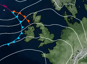
"And then what's next? Well, we still have high pressure building to the south and southwest. So lots of dry, settled conditions to come. But see once again across the northern flank of that high, still some frontal systems moving through. So still a chance of some more cloud and rain for these areas. And although we'll begin to feel a little fresher from Sunday, temperatures look like they are creeping back up again as we head into next week."
Keep up to date with weather warnings, and you can find the latest forecast on our website, on YouTube, by following us on X and Facebook, as well as on our mobile app which is available for iPhone from the App store and for Android from the Google Play store.


