
As we approach the summer solstice, the UK is bracing for a significant spell of hot weather.
With high pressure dominating the forecast and temperatures expected to climb into the low 30s, many parts of the country are likely to experience a technical heatwave. In this deep dive, we’ll explore the meteorological setup behind the heat, what to expect in the coming days, and how this ties into broader seasonal patterns.
The big picture: High pressure takes control
The story begins with the jet stream, which has been running just to the north of the UK. Over the past 24 hours, it brought some wet and blustery weather to parts of the northwest. However, a decaying front is now pushing south-eastwards, bringing cloud and drizzly rain before clearing away.
It's turning hotter later this week 📈
— Met Office (@metoffice) June 17, 2025
How high will temperatures get and will it be a heatwave where you are? Find out 👇 https://t.co/T1m66nhyMK 🥵 pic.twitter.com/HwZblteJt9
The main feature to watch is the high-pressure system building over the UK. As many will know, high pressure typically brings settled, dry, and sunny conditions, and that’s exactly what’s on the cards for the rest of this week.
While a few weak fronts may still affect northwestern areas, bringing occasional cloud and light rain, the dominant theme is one of sunshine and rising temperatures.
Temperature trends: Climbing towards the 30s
As we move through the week, temperatures are expected to rise steadily. By Thursday, many areas will see highs in the upper 20s. By Friday, we could see the first 30°C reading of the year in the UK.
Looking ahead to the weekend:
- Saturday: Will see temperatures potentially peak at 33°C, although forecast details are always subject to change.
- Sunday: We could still see temperatures in the 30s, but this would be limited to parts of east and southeast England.
However, there is some uncertainty, particularly for Sunday, depending on how far east or west the plume of warm air extends.
READ MORE: Met Office festival forecast: It's going to be a warm one
Where is the heat coming from?
Interestingly, this heat isn’t being imported directly from southern Europe or Africa. Instead, the air mass currently affecting the UK originated from the Labrador region south of Greenland, not a place known for warmth.
Six days ago, this air was around -10°C at 3-4 km above the ground. As it descended and sank under high pressure, it warmed at a rate of about 10°C per kilometre. This process, known as adiabatic warming, is a key driver of the current heat.
By the time this air reaches the UK, it has already undergone significant warming. Add in strong sunshine, especially around the solstice, and you have the perfect recipe for high temperatures.
Changing air trajectories through the weekend
As we head into the weekend, the trajectory of the air changes slightly:
- Saturday: The air takes a more southerly route, spending more time over northwest Europe. This allows for additional surface heating, especially over France, Belgium, and the Netherlands.
- Sunday: The setup becomes more complex. Some model runs show the warmest air shifting eastwards, while others keep it over the UK. This introduces uncertainty about just how hot it will get.
The short land track over the North Sea and English Channel means that southeastern England could see the highest temperatures, particularly on Sunday.
It's turning hotter later this week 📈
— Met Office (@metoffice) June 17, 2025
How high will temperatures get and will it be a heatwave where you are? Find out 👇 https://t.co/T1m66nhyMK 🥵 pic.twitter.com/HwZblteJt9
Model uncertainty: A closer look
Using ensemble forecasts, we can see a spread in possible outcomes:
- The most likely high for Sunday is around the low 30s in the east and southeast.
- However, there’s a larger spread below the most likely value, meaning cooler outcomes are more probable than significantly hotter ones.
This is due to several factors, including cloud cover, humidity, and the presence of a capping inversion, a layer of warmer air aloft that limits how high surface temperatures can rise.
The science of the capping inversion
A tephigram (a type of atmospheric profile chart) shows a shallow layer of air, about 5,000 feet deep, beneath a capping inversion. This acts like a lid, concentrating solar heating near the surface.
Think of it like boiling a kettle:
- A small amount of water heats quickly.
- A full kettle takes much longer.
Similarly, heating a shallow layer of air leads to faster temperature rises. But if temperatures climb too high, the air must break through the inversion and heat a much deeper layer, something that requires significantly more energy.
READ MORE: Met Office weather extremes: What are June’s current records?
Humidity: A key comfort factor
While temperatures will be high, humidity levels will vary:
- Central and eastern England: Lower dew points mean the air will feel drier and more comfortable, despite the heat.
- Western areas (Wales, southwest England, Northern Ireland, Scotland): Higher humidity will make conditions feel more oppressive, even though temperatures may be a few degrees lower.
As the weekend progresses, this humid air will spread eastwards, making Sunday feel more uncomfortable across a wider area.
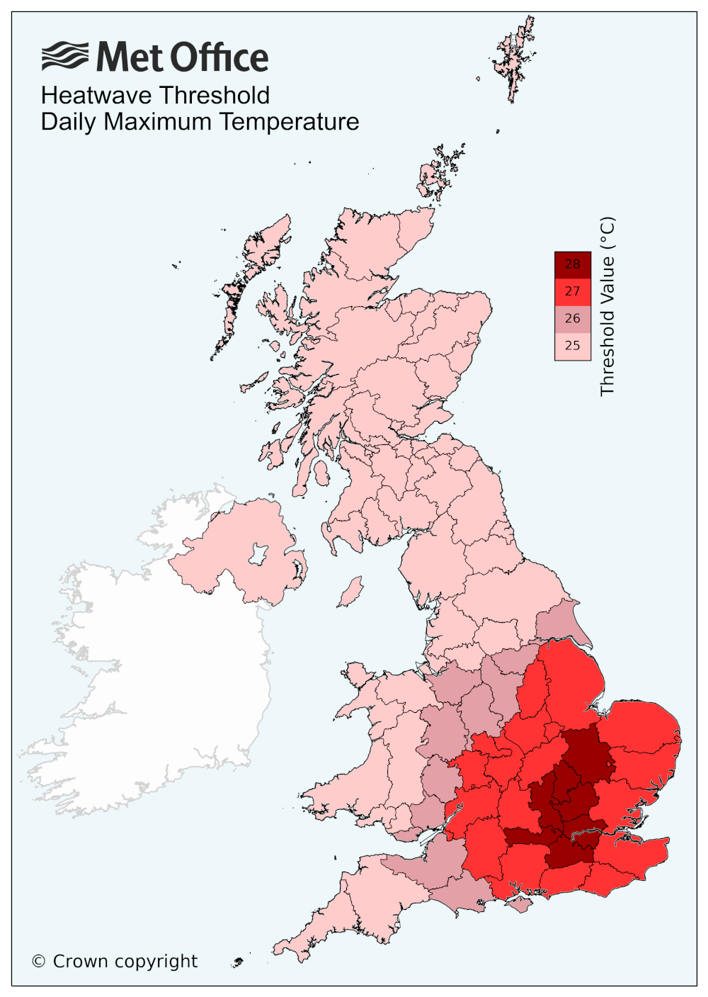
What is a heatwave?
A heatwave is defined as three consecutive days where temperatures meet or exceed a specific threshold. These thresholds vary by region:
- 25°C: Scotland, Northern Ireland, northern England, Wales, southwest England
- 26-28°C: Central and southeastern England
By Saturday, many areas, particularly in Wales, the West Midlands, and Somerset, are likely to meet the criteria. By Sunday, central and eastern England, and even parts of eastern Scotland, could also qualify.
So yes, a technical heatwave is likely for many parts of the UK this week.
Heat Health Alert issued
The UK Health Security Agency (UKHSA) has issued a yellow heat health alert for much of England, excluding only the northeast and northwest. This alert is valid from Wednesday through Sunday.
Key concerns include:
- Daytime highs in the high 20s to mid-30s
- Overnight lows staying above 20°C, so-called tropical nights
- Disrupted sleep and increased health risks for vulnerable groups
While most people will be fine with sensible precautions, hydration, avoiding peak sun, and checking on elderly neighbours, these conditions can be dangerous for those with underlying health issues.
Staying cool at home
Even with lower humidity in some areas, homes will heat up under prolonged sunshine. To stay cool:
- Keep curtains closed during the day.
- Ventilate at night when temperatures drop.
- Avoid using heat-generating appliances during the day.
These simple steps can help reduce indoor temperatures and improve sleep quality during hot spells.
READ MORE: 10 things you should do now to prepare for summer
Looking ahead: What’s next?
After this weekend’s heat, the weather may turn more changeable early next week. Low pressure systems could bring showers or even thunderstorms, particularly in the south and north.
However, there are signs that high pressure may return by the end of next week, good news for festivalgoers heading to Glastonbury and others hoping for more settled weather.
Tropical Storm Erick: Watching the Pacific
While the UK bakes, eyes are also on the Eastern Pacific, where Tropical Storm Erick is developing. It’s expected to strengthen into a hurricane by Wednesday and make landfall in southwestern Mexico on Thursday.
Impacts include:
- Heavy rain
- Strong winds
- Storm surge
While this system won’t affect the UK, it’s a reminder of the global nature of weather systems and the importance of monitoring developments worldwide.
It's turning hotter later this week 📈
— Met Office (@metoffice) June 17, 2025
How high will temperatures get and will it be a heatwave where you are? Find out 👇 https://t.co/T1m66nhyMK 🥵 pic.twitter.com/HwZblteJt9
Summer Solstice: The longest day
This Saturday marks the summer solstice, the longest day of the year in the northern hemisphere. While meteorological summer began on 1 June, the astronomical start of summer is tied to the Earth’s tilt and orbit.
Interestingly:
- The earliest sunrise occurred around 14 June.
- The latest sunset won’t happen until around 28 June.
This is due to the Earth’s elliptical orbit and axial tilt, which affect the timing of solar noon and the length of solar days.
As we head into the heart of summer, whether you're enjoying the sunshine or seeking shade, stay informed, stay safe, and stay cool.
Keep up to date with weather warnings, and you can find the latest forecast on our website, on YouTube, by following us on X and Facebook, as well as on our mobile app which is available for iPhone from the App store and for Android from the Google Play store.