The UK is currently experiencing its fourth heatwave of the year, with temperatures climbing well above seasonal averages.
Satellite imagery from the past five days shows the remnants of ex-tropical storm Dexter, which transitioned into an extratropical system as it approached the UK. While not expected to bring hazardous weather, Dexter has played a role in shaping our current conditions.
Initially forecast to pass northwest of the UK, Dexter’s influence was expected to be limited to a spell of wet weather. However, by midweek, the story evolved. Radar imagery revealed wetter conditions pushing into the northwest, with a secondary feature forming from Dexter and contributing to rainfall across parts of Scotland and northern England.
READ MORE: Are storms in August unusual and why do we name them?
Why is it so hot?
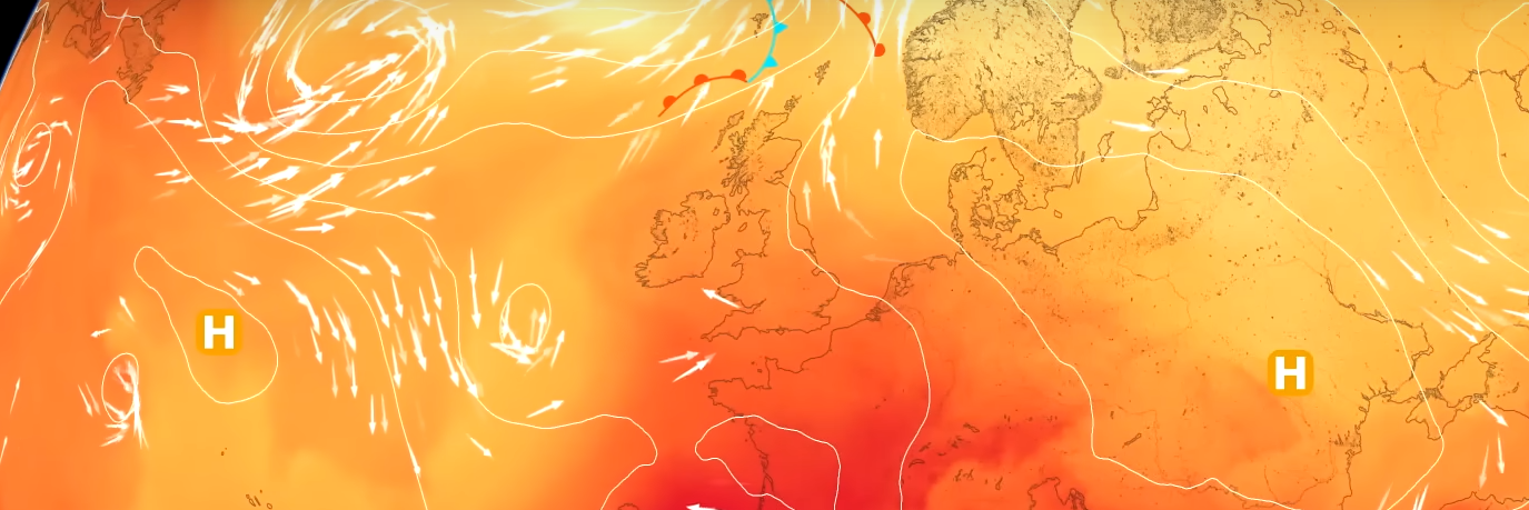
The presence of Dexter, combined with a southerly airflow and high pressure, has created a setup conducive to high temperatures. The jet stream has buckled, allowing warm air from the south and east to flow into the UK. This pattern has led to widespread warmth, with southern England seeing temperatures in the low 30s Celsius.
High pressure remains dominant, bringing settled conditions and strong sunshine. This has allowed temperatures to rise steadily day by day. While the exact location of peak temperatures varies, the Midlands and southern England have consistently recorded the highest values.
Looking ahead: temperature trends and thresholds
Met Office anomaly charts show that most of the UK is experiencing temperatures well above average. Scotland and parts of northern England are closer to seasonal norms, but the majority of the country is firmly in heatwave territory. For a heatwave to be officially recognised, temperatures must exceed specific thresholds for three consecutive days. These thresholds vary by region: 28°C in London and the southeast, 27°C in parts of the Midlands, and 25°C across much of Wales, northern England, Scotland, and Northern Ireland.
READ MORE: Met Office week ahead forecast: Hot spells for much of the UK
Many areas have already met or exceeded these thresholds, with temperatures expected to remain high through the week. Today may bring slightly fresher conditions to the southwest, but eastern areas could be even hotter than Tuesday. By Thursday, temperatures may dip slightly, with a 50% chance of reaching 30°C in certain areas. Friday is expected to see a resurgence of heat, particularly in the south-southwest.
Thunderstorm risk and rainfall outlook
With warm, humid air in place, there is a heightened risk of thunderstorms. Cloud cover across the southwest may bring light rain overnight, while Scotland faces the potential for heavier, thundery downpours. Forecast models suggest rainfall rates could exceed 50mm in three hours in parts of northwest Scotland. However, pinpointing the exact location of these showers remains challenging due to their scattered nature.
⚠️ Yellow weather warning issued ⚠️
— Met Office (@metoffice) August 13, 2025
Thunderstorms across Scotland
Wednesday 1400 – 2359
Latest info 👉 https://t.co/QwDLMfRBfs
Stay #WeatherAware⚠️ pic.twitter.com/DGBC5sZRn3
Two yellow weather warnings for thunderstorms have been issued. The first covers most of Scotland from 2pm Wednesday until midnight and the second continues from 12am Thursday until 10pm and covers Scotland and most of central and eastern Northern Ireland.
⚠️ Yellow weather warning issued ⚠️
— Met Office (@metoffice) August 13, 2025
Thunderstorms across Scotland
Wednesday 1400 – 2359
Latest info 👉 https://t.co/QwDLMfRBfs
Stay #WeatherAware⚠️ pic.twitter.com/DGBC5sZRn3
Thursday may see more widespread showers, particularly in Scotland, though most areas will continue to enjoy fine, sunny weather. Friday looks promising for England and Wales, with temperatures rising again. The weekend may bring showery bursts to the southwest and cloudier conditions along the eastern coast, but overall, the outlook remains warm and largely dry.
READ MORE: Met Office tips for staying cool during the heat
A look back at summer so far
So far, there have been 14 days with temperatures exceeding 30°C, compared to 10 last year. While we’re not yet at the 1995 record of 34 such days, the consistent warmth is notable.
The season has seen only brief, mild cooler spells, with most days either in heatwave conditions or several degrees above average. This persistent warmth is partly due to dry spring conditions, which left the ground with less moisture and more prone to heating quickly. Once a heatwave begins, the dry ground amplifies the intensity of subsequent hot spells.
Sea surface temperatures and climate impacts
The warming trend is also evident in sea surface temperatures. Data shows that the first seven months of the year have been around 0.2°C warmer than previous records dating back to 1980. Warmer seas hold less carbon and reduce the likelihood of cooling sea breezes, which can intensify heatwaves. Marine life is also affected, with species like cod migrating north and others, such as jellyfish, octopus, and bluefin tuna, becoming more common in British waters.
READ MORE: Understanding tropical nights and their impact
Satellite launch
In space news, a new weather satellite has been launched from French Guiana. This is the third launch of the Ariane 6 rocket series and marks the beginning of a new generation of polar orbiting satellites. These satellites will provide vital atmospheric measurements into the 2040s. Designed with active de-orbiting capabilities, they represent a significant advancement in reducing space debris and improving data continuity for weather forecasting.
Keep up to date with weather warnings, and you can find the latest forecast on our website, on YouTube, by following us on X and Facebook, as well as on our mobile app which is available for iPhone from the App store and for Android from the Google Play store.